12マイル (19.5 km)、徒歩での 自己最長記録ができました。 I set a new personal walking distance record of 12 miles (19.5 km).
家を出発して、近くの州立公園まで行って帰ってくるコースです。 The course started from home, went to the nearby state park and returned.
公園には南入り口から入り、北入り口近くの駐車場まで行きました。 I entered the park from the south entrance and walked to the parking lot near the north entrance.
ここは、10Kランのスタート地点でもありました。 This parking lot was also the starting point for the 10K run.
懐かしさと雄大な景色とで、単純に嬉しくて道で行き交う人たちとも話が弾みました。 The combination of nostalgia and the magnificent scenery made me simply happy, and I found myself happily talking to people I passed on the street.
こんな景色を見ながら、もうすっかり私のホームグラウンドになっているんだと自覚しました。 Looking at this view, I realized that this has now become my home ground.
美しい景色は疲れを忘れさせてくれますが、流石に公園を出た頃から疲れが出て来ました。休憩なしで歩きましたからね。 The beautiful scenery made me forget my tiredness, but as soon as I left the park, I started to feel tired because I had been walking without taking a break.
ロードランナーが私の前を走って励ましてくれたおかげで、なんとか家にたどり着く事ができました。 With the help of my friend, the Roadrunner, who ran ahead of me and encouraged me, I managed to make it home.
その後、トレーナーにこの偉業を誇らしげ伝えたら、護身用にペッパージェルを持って行きなさいと、1本いただきました。 Afterwards, I proudly told my trainer about my accomplishment, and she gave me a bottle of pepper gel to carry with me for self-defense.
山道じゃないから一人歩きでも大丈夫と思うのは軽率かもしれません。用心した方がいいですよね。さて、どうやって使うのかな? It may be reckless to think that it’s okay to walk alone because it’s not a mountain path. It’s better to be cautious. Now, how do I use it?
ザイオン国立公園内のウェストリムトレイル (West Rim Trail) は全長16.1マイル (26km), 高度差は3624フィート (1105m)です。 The West Rim Trail in Zion National Park is 16.1 miles (26 km) long with an elevation gain of 3624 feet (1105 m).
Appleマップによると9時間39分で歩けるそうですが、実際は10-16時間かかると言われています。逆に、Lava Point からロッジまで北から南に歩くと下り坂なので9-10時間、1日で完歩可能な範囲内です。ただ、高度7,897フィート (2,407m)を考えると、苦しいですよね。健脚向きです。 Apple Maps says the hike will take 9 hours and 39 minutes, but in reality it will take 10-16 hours. Conversely, walking from north to south from Lava Point to the lodge is a downhill hike and should take 9-10 hours, well within the range of a one-day hike. However, considering the altitude of 7,897 feet (2,407 meters), it is a strenuous walk. It is suitable for able-bodied people.
アップルの地図によるトレイルの全行程 Full trail route with Apple maps
この日、私たちはザイオンロッジからグロットを経て、北に向かい、行けるところまで行って引き返してくることにしました。 On this day we decided to head north from Zion Lodge via the Grotto, going as far as we could go and turning back.
ジグザグの苦しい登りからの眺め View from the painful zigzag climb
上の写真の景色を過ぎて、渓谷内に入ると、ビッグホーンシープが向かいの岸壁からこちらを見ていました。以下、ビデオです。 As we passed the view in the photo above and entered the canyon, a bighorn sheep was watching us from the opposite cliff. Here is the video
ビッグホーンシープのビデオ Bighorn Sheep Video
このトレイルは有名なエンジェルスランディングへいく道でもあります。 This trail is also the road to the famous Angel’s Landing.
ナイフの刃のように尖った上を歩いていくとエンジェルスランディングに辿り着きます。 Walking on the sharp edge of the knife like trail, you will reach Angel’s Landing.
ここは事前に申し込んで、抽選によって許可証がもらえた人たちだけが Scout Lookout から南下して行ける場所です。非常に人気があるので、私たちは未だに行った事がありません。 Only those who apply in advance and receive a permit by lottery can go south from Scout Lookout. It is very popular and we have not been there yet.
下の写真に示しているBig Bendからは、カリフォルニアコンドルが観察できる場所で有名です。 From Big Bend, shown in the photo below, is a famous place where California condors can be observed.
そんな分岐点を過ぎて北に向かい、下の図に示した折り返し点まで行きました。右上の方には、ザイオンのバスの終点があります。そこからさらに歩いていくと、有名な The Narrow という渓谷に行く事ができます。ここも人気スポットです。 After Angel’s landing turnoff, we headed north to the turn back point shown in the map below. In the upper right corner is the end of the Zion bus line. From there, you can walk further to the famous Zion Narrow’s canyon. This is another popular spot.
下の写真では、ザイオン渓谷を中世代から削り出してきたバージンリバーがうねうねとカーブして流れているのが見えます。ここがまさにザイオン国立公園の奥の景色です。 In the photo below, you can see the Virgin River, which has been carved out of Zion Canyon from the Mesozoic Era, undulating and curving its way through the valley. This is truly the landscape of Zion National Park.
ナバホ砂岩層の上方部は大抵白いです。ところが、下に下がると赤茶色なっています。その理由は、砂岩層内の鉄分の酸化によって変色しているわけですが、雨が砂岩層の中に浸透することにより変色した鉄分は下に移動していった。だからナバホ砂岩層は下の方が赤茶色なのだと聞いています。 The upper part of the Navajo Sandstone Formation is usually white. However, the lower part is reddish brown. The reason for this is that the discoloration is caused by the oxidation of iron in the sandstone layer, and as rain permeates the sandstone layer, the discolored iron migrates downward. This is why the Navajo sandstone layer is reddish brown at the bottom.
ここから先、終点のラバポイントまではまだ10-12時間かかると言われているので、人の量もグッと少なくなり、トレイルもゴツゴツとした険しい道になりました。 From this point on, the number of people decreases dramatically and the trail becomes more rugged and steep, as it will still take 10-12 hours to reach the end of the trail at Lava Point.
でも、景色は更に素晴らしくなって行きました。 But the scenery became even more spectacular.
そこには、なんとも言えない心地よい神秘的な空気が漂っていました。 There was a pleasant, mysterious air that was indescribable.
今まで一度も感じたことのない、まるで「お帰りなさい」と言われているような優しい景色に包まれていました。 I had never had such a feeling, as if I was being welcomed home.
バンちゃんも私ももう少し先まで行ってこの不思議な気持ちを確かめてみたいと思っていましたが、帰りの道のりを考えて断念しました。氷った地面も所々で見えていたし、気温も下がって来ていました。 Both Banchan and I wanted to go a little farther to check out this wonder, but we decided against it for the return walk. Ice on the ground was visible in places and the temperature was dropping.
凍った地面を見て帰ることにした折り返し地点。 The turnaround point where we saw the frozen ground and decided to go home.
全体の行程に比べるとほんの3分の1までしか歩けませんでした。 We walked only a third of the entire route.
Walking time: 5:07, Round trip walking distance: 9.45 miles (15.2 km), Altitude gain: 2,297 ft (700 m)
でも、ザイオンロッジにたどり着いた時は満足感に満たされていました。 But when we reached Zion Lodge, we were filled with satisfaction.
次回はもっと早くスタートして、カメラを持って、もう少し先まで行きたいです。あの、神秘的な景色を捉えてみたいです。 Next time I would like to start much earlier, take my camera and go a little further. I want to capture that mystical scenery.
年明けとはいえ、急激に何かを始めるといいことはないというお話です。 Even though it is the beginning of the year, I am going to talk about the fact that it is not a good idea to start something rapidly.
思い立って、車で行くと11分の所にある Tuacahn Amphitheatre という野外劇場に歩いて行ってきました。Appleマップでは片道95分、往復3時間10分と出ていたので、足慣らしにはちょうどいい距離です。 On the spur of the moment, I walked to Tuacahn Amphitheatre alone. It’s only 11 minutes away by car, which Apple Maps said would take 95 minutes one way and 3 hours and 10 minutes round trip to walk, so it was a good distance to get my feet wet.
去年、バンちゃんと私は歩行距離を伸ばしていき、11マイル(17.7km)歩いても問題ないところまで体力を鍛えていました。が、年末とあってしばらく休んでいました。 Last year, Banchan and I had increased our walking distance and built up our fitness to the point where we could walk 11 miles (17.7 km) without any problems. However, I took a break for a while because it was the end of the year.
しばらくぶりの運動に気持ちがいい。クラブハウスの前のサグワロはもう春を待ちきれず花を咲かせる準備に取り掛かっていました。 It felt good to exercise for the first time in a while. The saguaro in front of the clubhouse was already getting ready to bloom, unable to wait for spring.
アスファルト上を歩いたり走ったりする事を考えて、ランニング用の靴を履きました。今から考えると、それが裏目に出ていたかもしれないと思っています。 I wore running shoes, thinking about walking and maybe running on asphalt. In hindsight, I think that may have backfired.
走る練習をしていた時に使っていトレイルを歩き始めたら、びっくりです。クラブの敷地の境界線ギリギリまで巨大なリゾート施設が建設中だったんです。 When I started walking on the trail I used to use for running practice, I was surprised. A huge resort complex was being built right up to the very edge of the club’s property line.
溶岩流跡が広がって、何もなかったところがPGAゴルフトーナメントをホストする、巨大なリゾートに変化してしまったのです。賛否両論ですが、ちょっと悲しいです。 The lava flow which had spread widely over the area have now transformed into a huge resort that hosts PGA golf tournaments. To me it’s a bit sad though.
気を取り直して、どんどん歩いて2マイルを歩いた頃から右の足の付け根が徐々に痛くなって来ました。あー、そうだったと、関節唇(かんせつしん)の損傷があったので走ることを辞めていたことを思い出しました。 I regained my spirit and walked more and more, and after walking two miles, my hip joint on my right side began to gradually ache. Oh, that’s right, I remembered that I had stopped running because of the damage to my labrum articularis.
ここで引き返しても良かったのですが、そのうちに治ると根拠のない自信があり、歩き続けました。上り坂ではありますが、大したことはなかったです。1マイル20分のペースで無事、劇場の入り口に辿り着きました。 I could have turned around at this point, but I had confidence that I would recover along the way, so I kept walking. It was uphill, but no big deal; I made it to the entrance of the theater safely at a pace of 20 minutes per mile.
かつて、この劇場でボランティアをしていた事があったので、舞台裏の方まで知っています。馬に新年のご挨拶をして、パドレキャニオンというトレイルの入り口も左に見て、劇場を去るころには痛みがかなりひどくなっていました。 I used to volunteer at this theater, so I even know the backstage area. I wished the horses a Happy New Year and also saw the entrance to the Padre Canyon trail, to the left, and by the time I left the theater, the pain was getting much worse.
5マイルを過ぎたころ、走ってみたらどうなるのだろう。早く帰れることになるわけだしと思いつき、走り始めました。もちろんゆっくりです。 After five miles, I wondered what would happen if I ran. I figured it would mean I would be able to get home faster, so I started running. Slowly, of course.
そうしたら、なんと奇跡です。痛みが消えました。そのかわり、一気に心拍数は上がり、汗がどっと出て来て、走っていた時の感覚が蘇って来ました。気持ちがいい。 Then, what a miracle. The pain disappeared. In turn, my heart rate increased all at once, sweat came pouring out of me, and the sensation of running came back. It felt so good.
ところが、今度は左足の甲が痛くなってきました。家に着く前の最後の登り坂、息が苦しいのではなく、甲の痛みに苦しい思いをしました。 This time, however, the instep of my left foot began to hurt. On the last uphill climb before reaching home, I suffered not from breathlessness but from the pain in the instep.
徒歩5.87マイル(9.45km)、ラン2.3マイル(3.7km)、トータル8.17マイル(13km) Walk 5.87 miles (9.45 km), Run 2.3 miles (3.7 km), Total 8.17 miles (13 km)
早速シャワー、足のマッサージ、筋肉痛のクリームなどを塗ったら治ったみたいです。 A quick shower, foot massage, and muscle pain cream seemed to cure the problem.
その後、色々調べた結果、私の痛みの原因は急激な運動と以下の3点に起因しているようです。 After much research, it seems that my pain was caused by rapid exercise, and the following three factors.
しばらく筋トレをしていなかった。 I hadn’t done any workout for a while.
平らなアスファルトだからとたかを括り、ストレッチせず手抜きをした。 I cut corners and didn’t stretch, thinking it was just flat asphalt.
左足の親指が靴の先にあたっていたので、親指をかばうように曲げていた。 My left big toe was hitting the tip of my shoe, so I curled it in to protect it.
いい教訓となりました。 It was a good lesson learned.
アメリカドクトカゲ:野生動物保護の会の展示場にて。 Gila monster: at the Wildlife Refuge’s exhibit.
今年は体力作りの年。そして、往復14.5マイル (23.3km) のコロブアーチ登山を1日で達成したい。また、私の5年越しの目標、アメリカドクトカゲに出会う。そのためには、歩き回ることしかありません。 This is the year of fitness. And I want to accomplish the 14.5 mile (23.3km) round trip Kolob Arch hike in one day. Also, my goal over the past 5 years, is to see a Gila monster. The only way to achieve this is to walk around a lot.
暑いので、私たちは朝3時半に起きてザイオン国立公園の西に向かいました。 It was hot, so we got up at 3:30 AM and headed to the west side of Zion National Park.
日の出前だったので、月が山の後ろに見えていました。 Just before sunrise, the moon was visible behind the mountains.
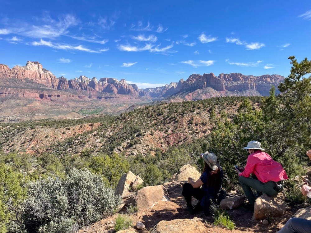
これがザイオン国立公園の全体像です。ほとんどの観光客は南ゲートから入り、赤い線で引かれた中心部の渓谷を見て帰ります。残念なことにここはシーズン中は世界中から来てくださる人たちで溢れかえっています。 This is the overall view of Zion National Park. Most visitors enter through the south gate, see the central canyon outlined in red, and leave. Unfortunately, this place is overflowing with people from all over the world during the season.
だから私たちはそこには滅多にいきません。そして、今回は西側に位置するノースゲイトピークに登りました。 So we seldom go there. And this time we climbed Northgate Peak West.
西ノースゲイトピークからは北のガーディアンエンジェルが目の前に見えます。南のガーディアンエンジェルはその後ろに位置します。 From Northgate Peaks West, the North Guardian Angel is visible in front of it. The South Guardian Angel is located even further behind it.
地図を西ノースゲイトピークからの写真に置き換えると、こうなります。 Replacing the map with a photo from Northgate Peaks West, it looks like this:
北と南のガーディアンエンジェルスはその間を流れる川、フォークノースクリークをガードしている山だったんですね。そして、この川こそ知る人ぞ知る、サブウェイと呼ばれる、健脚向けの16kmのハイキングコースです。許可がないと入れません。 So the two Guardian Angels, North and South, were the mountains guarding the river that runs between them, the Left Fork North Creek. And it is along this river that those in the know call the Subway, a 10 mile round trip hiking trail for strong hikers. BTW, You cannot enter without a permit.
ここからの景色を見ながら、ザイオンの全体像が少しわかってきました。 The view from here gave me a little more of an overall picture of Zion.
以下の赤い点線が昨日歩いたコースです。青い点線は先週歩いた山で、パインバレーピークと名付けられています。 The red dotted line below is the trail we hiked yesterday. The blue dotted line is the mountain we hiked last week, named Pine Valley Peak.
地図上でわかるように、長いアプローチの後、白い部分に入ります。つまり、ここから本格的な山登りが始まるわけです。 As you can see on the map, after a long approach, you enter a white section. In other words, this is where the real mountain climbing begins.
トレイルがあるわけではなく急勾配なので、頂上に近い場所は特に神経を使って一歩前に踏み込んで、また次の踏み込み場所を探すというスリリングな山登りをしました。 There is no trail, but it is steep, so we had a thrilling climb up the mountain, especially near the top, where we nervously took one step forward and then looked for the next place to climb again.
Here is a short trivia break: The rocks in Zion National Park are Navajo sandstone. They were formed by sedimentation when the area was once an ocean. So they are covered with sandy flow lines. And then erosion over a long period of time exposed the sandstone. Then water washed the heavy iron downward through the sandstone, so the lower part is a rusty red and the upper part has lost its color and is white.
さて、突然ですが、なぜハイキングが好きなんですかと聞かれた、どう答えますか? Well, it’s a sudden question but if someone asked you why you like hiking, how would you answer?
私の答えは、ハイキングでなくても、ただ外を歩いているだけでも同じです。たくさんの発見があるから楽しくてしょうがないんです。 My answer is the same, even if I am not hiking, just walking outside. I have so much fun because I discover many things during the walk.
発見がたくさんありすぎて消化しきれません。山道を歩いていると、地面の石ころでさえ面白い。下の写真は、コンクリーションが進んでいるものです。何千年もの時を越えて変化していく様を垣間見ているようです。 There are too many discoveries to digest. Even the stones on the ground are interesting when walking along the mountain paths. The photo below shows a concretion in progress. It is like catching a glimpse of change over thousands of years.
こちらはマツヨイグサ。朝見た時は元気だったのに、帰りにはもう萎んでいました。たった数時間の間の出来事です。こんな小さな発見に心を動かされます。 This is Fragrant Evening Primrose. It was healthy like the picture below when I saw it in the morning, but it had already wilted on the way back to our car. It happened in just a few hours. I am moved by such a small discovery.
発見は感動につながります。美しいものはそのままで感動を呼び起こしてくれます。 Discoveries are inspiring. Beautiful things evoke an emotional response just as they are.
苦しい登り道も、体を動かして汗を流すことも楽しいです。美味しいものを食べられるから。 I enjoy the painful uphill climb and the physical exertion and sweat. Because I can enjoy eating good food.
でも、早起きはやっぱり好きになれないなぁ。 But I still don’t like getting up early.
ザイオン国立公園の西側、パインバレーピークのトレイル沿いに咲いていました。 It was blooming along the Pine Valley Peak trail on the west side of Zion National Park.
この花がなぜ州の花に指定されているかというと、昔、飢饉で食糧難になった時に、この花を食べて命を繋いだと言う話が残されているからです。いろいろなレシピがあるようです。 The reason why this flower is designated as the state flower is because there is a story that in the past, when there was a shortage of food, people ate this flower to save their lives. Even today, there are various recipes for this flower.
ところで、このハイキングですが、気温が40度近くまで上がるので、6時半ごろから歩き始めました。 This hike, by the way, started around 6:30 a.m. because the temperature rises to nearly 105F degrees.
久しぶりのザイオンは気持ちが良かったです。雪もすっかり溶けて、水溜りもあまり残っていませんでしたが、いくつか見つけた所ではカエルが気持ちよさそう泳いでいました。 I hadn’t been to Zion in a long time and it felt good. The snow had melted and there were not many puddles left, but there were frogs swimming happily in some of the places we found.
また、こちらのビデオはアメンボウとオタマジャクシが狭い水の中でひしめき合っているところ。 Also, here is a video of water striders and tadpoles that are crammed together in a tiny pool.
ザイオン国立公園に向かう途中に必ず目撃するゴツゴツとした岩山は、ワシが住む岩山として知られています。 The craggy rocky mountains that you are sure to see on your way to Zion National Park are known as Eagle Crags.
距離は9.5km、標高差は368m。ゴツゴツとした岩場を登っていきました。 The hiking distance was 5.85 km and the elevation gain was 1,200 feet. We climbed up rugged, rocky terrain.
ザイオン国立公園の岩山を眺める場所で休憩です。 We took a break at a place with a view of the rocky looking mountains of Zion National Park.
ハイクリーダーが、その後、ますます険しくなる道のりを説明しているところです。 The hike leader explained to us about the increasingly rugged path from then on.
結局、この岩の麓まで登り、引き返してきました。ここから先はまさに岩登りになるからです。 In the end, we climbed up to the foot of this rock and turned around, because from this point onward, it would be a difficult rock climb needing ropes.
もう夏かと思わせる暑さで、野草は嬉しそうでした。It was so hot that one would think it was already summer. The wildflowers looked happy.
朝5時半に家を出て、夜7時半に帰宅。ザイオン国立公園の東、パラヌウィープのルートのないルートを一周して帰ってくるハイクは17km、670mの標高差、所要時間10時間のハイキングでした。 We left home at 5:30 am, and returned home at 7:30 pm. This hike, in the east side of Zion National Park, is a total of 10.5 miles, 2,300 feet elevation gain, and 10 hours of hiking.
バンちゃん提供 Courtesy of Banchan
多分、私のハイキング歴の中でも一番苦しいハイクだったかもしれません。 It was probably the hardest hike of my hiking history.
ただ、息を呑む絶景だったことは確かです。 However, the views were breathtaking.
このハイクが予想以上に苦しいものになった大きな理由は、二つ。一つ目は、雪がまだ残っていたことと。 There were two main reasons why this hike turned out to be more difficult than expected. The first was that there was still snow on the ground.
二つ目は、雨の日が続いていたので、岩の至る所から水が流れてきていた事、ひいては普段はない乾いた川に水が流れていた事でしょう。 Second, it had been raining, so water was flowing out from the rocks, and by extension, usually dry washes, were flowing rivers.
橋のない川を渡るという洗礼を受け、クイックサンドに飲み込まれないように歩いていきました。ここでかなり神経をすり減らしてしまいました。下の写真の彼は膝の上まであっという間に沈んでしまいました。 We had the baptism of crossing a river with no bridge, and walked through the wash trying to avoid being swallowed by quicksand. I lost a lot of nerve here. The person in the photo below sank quickly above his knees.
ザイオン公園内はイースターバケーションでものすごく混んでいましたが、私たちのハイクは道のないルートなので、勿論、車を降りてから帰ってくるまで、私たち以外誰も見かけませんでした。 It was extremely crowded in Zion because of Easter Vacation, but our hike was on a trail-less route, so of course we saw no one but us from the time we got out of the car until we returned.
登りはお互いの足に捕まったり、お尻を押し上げてもらったりして急な岩場を登りました。 We climbed the steep rocky terrain using each other’s legs to hold onto and sometimes getting a helping hand to push our butts up.
降りは、お尻をズリズリと滑らせました。On the descent, we often slid down on our butts.
水が岩の隙間から流れ出していて、岩肌が滑りやすくなり、実際、仲間の一人が滑って転んでしまいました。その際、肩を脱臼してしまい、途中で下山し、病院に担ぎ込まれました。 Water was flowing out of the crevices of the rocks, making the rock face slippery. And in fact, one of our group members slipped and fell. In doing so, she dislocated her shoulder and was taken down the mountain to the hospital by a couple of our hikers.
雪投げをして楽しそうなハイクリーダーの隣で、私は小さな雪だるまを作ってあげました。 While our hike leader was having fun throwing snowballs, I made a little snowman for myself.
パルヌウィープの高原は1850mぐらいです。だから、それほど高いわけではないです。それでも頂上で生きる植物の生存のための努力は大変なものだろうと思われます。 The top of Parunuweap is about 6,200 feet. So it is not that high. Even so, survival for the plants plants living on the summit must be very hard.
下の写真には、左にウェストテンプル、右にイーストテンプルと、両方のテンプルが収まっています。 In the photo below, both temples fit together, with the West Temple on the left and the East Temple on the right.
崖の上から下を見下ろすと、バージン川が細くウネウネと流れていました。 Looking down from the top of the cliff, I saw the Virgin River flowing in what looked like a thin stream. far below.
頂上に溜まっていた水。これから暑くなると一気になくなってしまいます。 Water that had accumulated in a pool at the top, will disappear once it gets hot.
さあ、十分に頂上でくつろいだので、(とはいえ、大抵10分以内ですが)これから下の写真の下白い頭のフーデューの森を超えて下っていきます。 Now that we’ve had enough of relaxing at the top (though usually less than 10 minutes), we will now descend beyond the lower white-headed hoodoo forest in the photo below.
どこまで行っても自然が作り出したフォームは美しい。 Wherever you go here, the forms created by nature are beautiful.
私たちは謙虚な気持ちでそんな美しさの中を歩かせてもらいました。 We were humbled to walk in such beauty.
何回か携帯を落とし、一度は15mぐらい下に転がってしまい、もうダメかと思いましたがなんとか事でした。ただ、この写真を最後に、バッテリー切れとなりました。 I dropped my phone several times and once it rolled down about 50 feet and I thought it was done for. My cell phone was somehow safe, but after this picture, the battery ran out.
最後に、ザイオンのモキボールについて書きます。大きいです。家の近くのモキボールはこのぐらいです。Lastly, I would like to write about Zion’s Moqui Balls. They are big. The moqui balls near my house are about this big.
でも、ザイオンの茂木ボールは、こんなに大きい。 But Zion’s Moqui Balls are so much bigger.
私の顔と同じぐらいの大きさ。ザイオンの自然はデッカイ! About the same size as my face. Nature in Zion is huge!
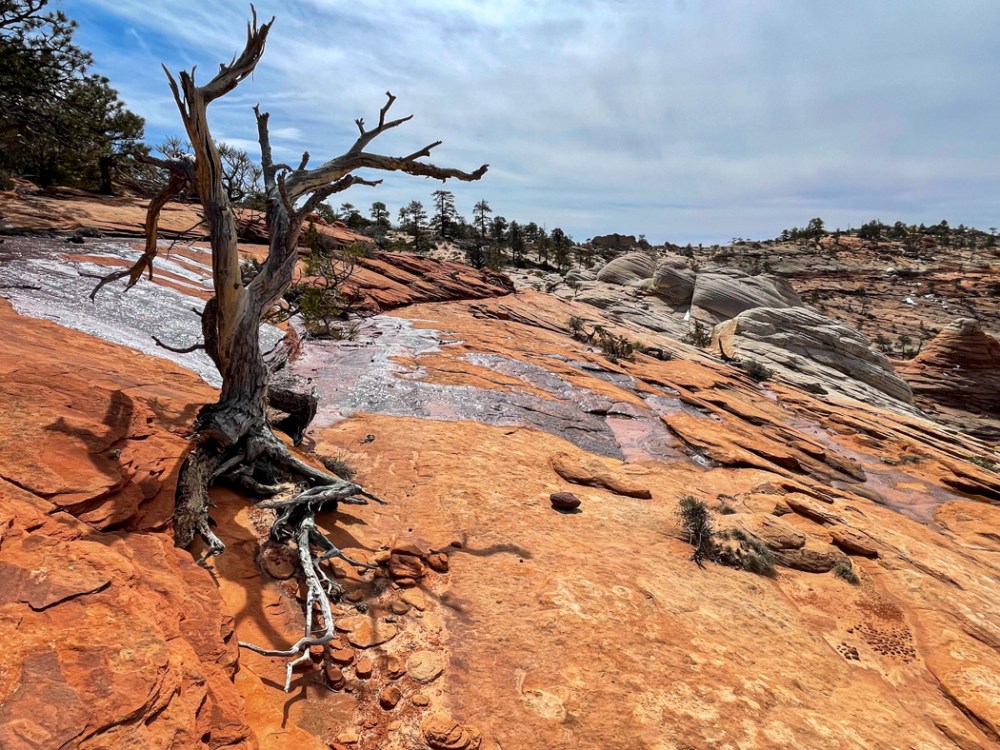
スノーキャニオン州立公園は、私の大好きな場所です。この日はその中にあるホワイトロックの一番高い場所、トップオブザワールドロックに登りました。 Snow Canyon State Park is one of my favorite places. We climbed the highest point of the White Rocks called which we called “Top of the World” on the day of the hike.
雨が降り続いていたので至る所に水溜りができていました。 It had been raining so hard the past few days that there were puddles of water everywhere.
巨大な亀の甲羅のようなナバホ砂岩の上を、慎重に慎重に歩いてドンドン高度を上げました。 We walked carefully and cautiously over Navajo sandstone that looked like the shell of a giant turtle, and gained altitude rather quickly.
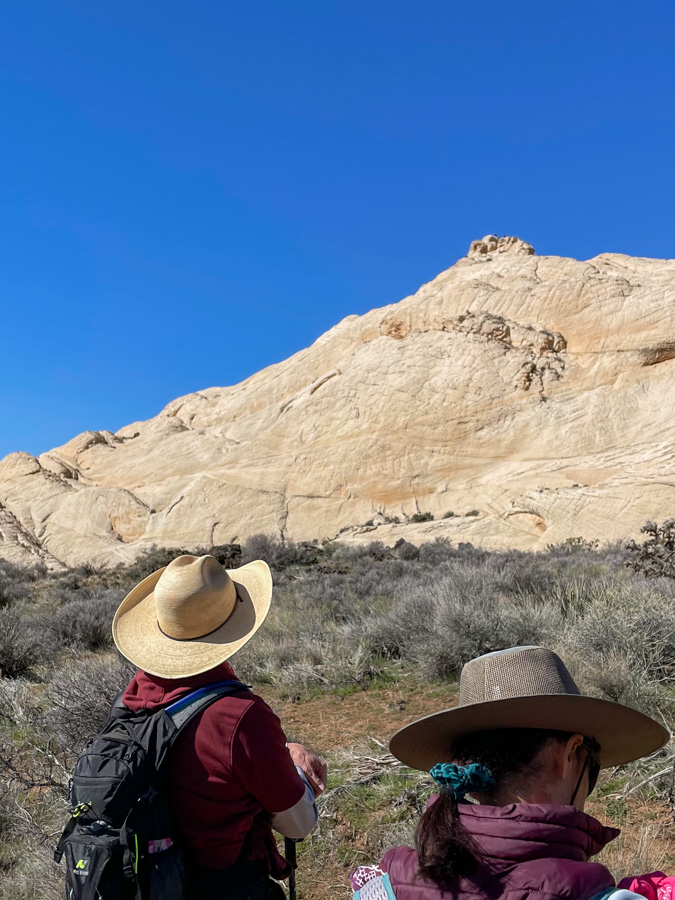
目指す頂上が見えてきました。 The summit we were aiming for was now in sight.
最後の登りの前、眺めはすでに最高です。 Before the final climb, the view was already great.
ハイーダーのジムの写真。私も一番手前に入ってます。 Photo credit: Jim, the hike leader. I am at the very right.
でも、この岩場はとりわけ慎重に歩きました。 We were especially careful on the final rocky area.
これが頂上からの眺めです。 This is the view from the top.
狭いので、立つのもちょっと怖いほどでしたが、ハイクリーダーのジムはロッククライマーなのでマウンテンゴートのように軽やかに歩いてました。 It was so narrow at the top that it was scary to stand on for me, but Jim, the hike leader, is a rock climber, so he walked like a mountain goat.
平地に戻ってからトップオブザワールドロックを見上げ、「よくやったね!」と、自分を褒めてあげました。 When we got back to level ground, I looked up at the Top of the World Rock. I said, “You did great!” praising myself.
距離は6kmぐらいしかありませんでしたが、一歩一歩慎重に歩いたので、時間がかかりました。 The distance was only about 3.7 miles, but it took a long time because we walked carefully step by step.
雨あがりの後のハイキング、気持ちよかったです。 It was a nice hike after the rain.
トレッドミルを使った仮想登山です。テヘッ! This is a virtual hike with a treadmill. Why not?!
私の使っているトレッドミルのプログラムは、富士宮ルートを歩きます。4.3kmを7回に分け、1回分を20分から25分ぐらいにしています。 The treadmill program I use lets me walk the Fujinomiya route, which is 4.3 km divided into 7 parts, each part lasting about 20 to 25 minutes.
私は、2日間に分けて登頂完了しました。
パート1のスタート画面の写真を撮り損ったので、その代わりにこ結果画面です。 I forgot to take a picture of the start screen of part 1, so here is the result screen instead.
歩きはじめということもあり、上りがなだらかで、ちょっと気抜けしてしまいました。だからスピードをアップして歩きました。 Since it was the beginning of the walk, the uphill was gentle and I was a bit disappointed. So I changed to a faster speed.
パート2のスタートの画面。 Screen shot of the start of part 2.
パート2になると、突然勾配が30%と急上昇し、トレッドミルの上を歩くのもちょっと危ない程になりました。ここがバーチャルのいいところで、自分で勾配を変えられます。20%から10%、最後の方では8%ぐらいで歩いてました。 In part 2, the gradient suddenly spiked to 30%, making it a bit dangerous to walk on the treadmill. This is the nice thing about virtual, you can change the gradient yourself, from 20% to 10%, and towards the end I was walking at about 8%.
パート3。 Part 3.
パート3でも高度をたくさん稼いだことになります。 I gained a lot of virtual altitude in part 3. This is actually the case for parts 2 to the end.
わかったことは、時間が一定なので、スピードを上げても早く着く訳ではなく、距離を稼ぐだけだということです。だからスピードも勾配もプログラム通りにしておく方がいいです。 What I found out is that since the time is constant, increasing the speed will not get you there faster, it will only increase the distance. So it is better to keep both speed and gradient as programmed.
多くの人たちは、富士宮ルートの5合目から頂上までの4.3kmを4-5時間ぐらいで登るらしいです。標高が 2,400m から 3,776m まであるので早く歩くわけにはいかないんですね。 Most people climb the Fujinomiya route from the fifth station to the top, a distance of 4.3 km, in about 4-5 hours. The altitude ranges from 2,400 to 3,776 meters, so it is not possible for a normal person to walk fast.
もう20年以上前のことですが、私も富士山頂まで息子と二人で登りました。このルートではなかったと思いますが、二人とも高山病になってしまい、下山するまで苦しみました。 More than 20 years ago, my son and I hiked to the top. I don’t think it was this route, but we both got altitude sickness and suffered until we descended.
—
二日目。残りのパート4から7までを歩き、無事、頂上に立つ事ができました。へへッ! Second day. I walked the remaining parts 4 to 7 and successfully made it to the top. Grin.
パート4。Part 4.
このパートでも高度を稼ぎましたが、トレッドミルの勾配数を変えずに歩いてみました。 I gained altitude again in this part, but walked without changing the default gradient on the treadmill this day.
パート5のスタート。 Part 5.
勾配が30%もあると、それだけで汗ダラダラになります。 With a slope of 30%, it is enough to make you sweat a lot.
結構疲れてきていたためか、パート6のスタート画面を撮り忘れました。 Perhaps because I was getting quite tired, I forgot to take a picture of the start screen for part 6.
パート7のスタート。 Part 7.
頂上の火口近くなので、ここまでくると登りはそれほどなくなりました。 Since I was near the crater at the summit, there was not much more climbing to do up here.
30%の急勾配を歩いている最中に、「エベレストでも目指してるの?」なんて言われました。 As I was walking up the steep 30% grade, someone asked me, “Are you aiming for Mount Everest?”
アイディアいただきです。次回はエベレストに挑戦もできる! Thank you for the idea. Next time I can try for Everest!
雨が降る日には、仮想登山、楽しいです。 On rainy days, it’s fun to do a virtual hike.
日暮れを待って、近くの丘、私たちのMVロックのある丘からタートルウォールをぐるりと回って帰ってくる、6.5kmの道をご近所さん達と歩きました。 We waited for nightfall and walked with our neighbors on a 4 mile loop trail heading up to our MV rock, around the Turtle Wall and back.
暗くなってから月が出るまでの15分程度の時間は、ご近所さん達との情報交換をしました。 After dark and before moonrise, we spent about 15 minutes getting to know our neighbors.
この写真は友人提供です。This photo is courtesy of a friend.
近所を歩き回る事があまりないので、すぐ近くなのに知らなかった隣人とも話す事ができました。 Since I don’t often walk around the neighborhood, I was able to talk to neighbors I didn’t know even though they were right around the corner.
月を撮るのは難しい。 It is difficult to photograph the moon.
暗い山道をヘッドランプで歩くのは初めてです。楽しい思い出になりました。 This is the first time for me to walk on a dark mountain trail with a headlamp. It was a fun memory.
ネバダ州のゴールドビュート国定公園には、面白い場所がぎっしり満載です。You can find so many interesting places to visit at Nevada’s Gold Butte National Monument.
12kmほどのハイキング。巨岩群の中にはペトログリフがびっしりと隠されていました。It was a 7.5 mile round trip hike. So many petroglyphs were hidden in the giant rocks.
巨岩を登ったり降りたりすると、次から次へとペトログリフが見つかります。 As we climbed up and down the huge rocks, we found one petroglyph after another.
ほとんどの物は意味不明ですが、逆さまに描かれている物は、死んでいることを意味しているそうです。 Most of the meanings are still unknown, but an object drawn upside down is said to mean that it is dead.
ほとんどの物は線画ですが、2点だけ、塗りつぶすように描かれていました。足のように見えます。 Most of the objects were line drawings, but I found only two drawings that were filled in like in the picture below. It looks like a foot to me.
ペトログリフは勿論見る価値ありですが、その周りの景色も最高です。 The petroglyphs are no doubt worth seeing, but the surrounding scenery is also excellent.
ここはリトルフィンランドと呼ばれています。 This place is called Little finland.
いつものことですが、自然の創造物は不思議で、その美しさにはかなわないと思い知らされます。 As always, I am reminded that nature’s creations are wondrous, and that there is no substitute for their beauty.