ジュース洗浄が終わり、朝、残っていたジュースを飲みました。ジュースダイエットはこれで本当に終了です。 After the juice cleansing was finished, I drank the remaining juice in the morning. The juice diet is now truly over.
朝食にバンちゃんんが卵2つを使ってスクランブルドエッグを作ってくれました。ありがとう! Banchan made scrambled eggs with two eggs for breakfast. Thank you!
彼はフルサイズの朝食でした。 His was a full sized breakfast.
その後、今までしようと思っていたけれど出来なかった面倒臭い作業に取り掛かりました。私が毎日とっているサプリメントの栄養成分を Excel シートに書き出すという作業です。同時に、よく食べる食べ物もリストアップしました。 After that, I began a tedious task that I had been meaning to do but could not. It was to write down the nutrition facts of my daily supplements on an Excel sheet. I also listed the foods I eat most often.
やって良かったです。必要以上にとっている成分、足りない成分などの発見がありました。 I am glad I did it. I discovered what ingredients I was taking more of than I needed and what ingredients I was not getting enough of.
その後、近所を散歩したら、もう鳥たちが巣作りに忙しそうでした。 Later, when I went for a walk in the neighborhood, the birds were already busy building their nests.
追記:3ポンド(1.3km) 減量しました。 Note: I lost 3 lbs (1.3 km).
トレーナーに勧められて、3日間のジュース体内洗浄を水曜日から始めました。今日は、最終日です。 I started a 3-day juice cleanse to remove toxins from my system on Wednesday as my trainer recommended it. Today is the last day.
リンゴ、ブドウ、ニンジンの中から好きなジュースをまず選びます。そして、3日間、そのジュースだけを飲み続けるだけという、簡単なものです。私の場合はリンゴを選んだので、少しのリンゴそのものも食べて良いとのことでした。 You first choose your favorite juice from apple, grape, or carrot. Then, simply drink only that juice and eat that fruit for three days.
毎日ジュース飲んでるよ。。。花の蜜はジュースと違うんですけど。 I drink juice every day… Flower nectar is different from juice, though.
だから、軽い気持ちで始めました。目下、頭が痛いです。多分、普段飲んでいるコーヒーを飲んでいないからだと思います。 So I started it casually. I have a headache at the moment. Probably because I am not drinking my usual coffee.
花粉症なので、目がかゆく、くしゃみ連発、喉が痛いといった症状もありますが、薬を飲んでいないので、さもありなんです。 I have hay fever, so I have itchy eyes, sneezing fits, and a sore throat. Because I am not taking medication during this cleanse as well, so there is that.
指先に力が入らないのも、食べていないから当然でしょう。思考を伴う作業は集中できないので諦めました。 It’s no wonder I have no strength in my fingertips, because I haven’t eaten. I gave up activities involving thinking because I can’t concentrate.
以上のような症状以外は大したことはないです。 Other than the above symptoms, it is no big deal.
なぜ、このジュース洗浄を勧められたかというと、花粉症や便秘気味、不眠症などの問題があったからです。それらに対処するために、一度体内洗浄をして、そこから何を摂取していけばいいのかを一つづつ確認していくのが目的です。 The reason why this juice cleansing was recommended to me is because I have been having problems with hay fever, constipation, insomnia, etc. The purpose of the program is to address these issues once I have cleansed my body and see what I can take from there, one by one.
虫はたべてもいい。 I can eat bugs.
以前、友人が4毒(小麦(グルテン)類、乳製品、植物油、砂糖)断ちをしているということを話してくれました。そこで、試しに、パン、パスタなどの小麦類を100% やめてみました。すると、驚異的にお腹の張りがなくなりました。グルテンフリーは他人事と思っていたので、本当にびっくりしました。 A friend of mine once told me about her 4-toxin (wheat (gluten), dairy, vegetable oil, and sugar) abstinence. So, as a trial, I stopped eating all bread, pasta, and other wheat products. Then, my stomach was phenomenally relieved. I was really surprised because I thought “gluten-free” was someone else’s problem.
ナッツは食べても良い。 I can eat nuts.
この驚異の事実をトレーナーに話したら喜んでくれましたが、その反面、4毒に関しては納得してもらえませんでした。とりわけ、オリーブオイルに関しては、断固反対されましたネット上でも賛否両論です。オリーブも植物なのだから、他の植物同様に悪い油となるわけで、摂取しない方がいいわけです。でも、なぜオリーブオイルだけ例外であるのかの理由がまだ不明確です。 When I told this fact to my trainer, she was pleased, but on the other hand, she was not convinced about the 4 toxins. In particular, there are pros and cons regarding olive oil. Since olive is a plant, it would be a bad oil just like any other plant, which is why it should not be consumed. But the reason why olive oil is the only exception is still unclear to me.
個人的には、オリーブオイルは私の最後の砦です。他の油は一切使うのをやめたので、調理にはオリーブオイルがなくなったら非常に困ることになる。だから、納得できる例外の理由が見つかって欲しいです。 Personally, olive oil is my last resort. I have stopped using any other oil, and I would be in very serious trouble if I lose olive oil for cooking. So I hope someone can find very good convincing reasons for why it’s an exception.
その他、ハチミツは良いという人もいれば、やはりダメという人もいます。また、乳製品に関しても、例えばパルメザンチーズはいいという人もいれば、全てダメという人もいます。 In addition, some people say that honey is good, while others say it is not. Some people say that dairy products, such as parmesan cheese, are good, while others say that all dairy products are bad.
こんなことを調査し始めると、ますます複雑怪奇になっていき、何も食べられなくなります。「食」は生きていく上で大切な喜びの一つです。だから、そんなに厳しい制約は設けたくない。 When I start to investigate such things, it becomes more and more complicated and bizarre, and I can’t eat anything. Food” is one of the most important pleasures in my life. So I don’t want to set such strict restrictions.
あくまでも今のところですが、私が健康維持のために実行できそうなことは以下です。 This is just for now, but here are some things I could implement to maintain my health.
買い物の際は、食品添加物の毒に気を付ける。 When shopping, watch out for food additives.
TVディナーなどの冷凍食品やインスタント食品を決して食べない。 Never eat frozen or instant foods such as TV dinners.
なるべく自分で料理をする。 I cook by myself as much as possible.
グルテンを出来る限り避ける。 Avoid gluten as much as possible.
はちみつ以外の糖質と乳製品を積極的に摂らない。 No active intake of sugars and dairy products other than honey.
以上を守るだけでも私の健康はかなり向上すると信じています。I believe that just by adhering to the above, my health will improve considerably.
時々お菓子も食べて良いよね? I can have junk food now and then, right?
さあ、明日朝一番、何を食べようかな。 Now, what shall I eat first thing in the morning tomorrow?
Thanks for the long time. I will live well without you from now on! RIP
旅行中、iPad が突然心肺停止してしまいました。 While traveling, my iPad suddenly went into cardiac arrest.
帰ってきてから医者(コンピュータ機器の修理屋)に見せたら、「マザーボードに原因がある」と言われました。治しようがないと言われたと同じことです。 When I returned home, I showed it to a doctor (a computer equipment repairman) and he told me that the motherboard was the cause of the problem. It was the same thing as being told there was no cure.
壊れてから2週間が経ち、iPad なしでは不自由かなと危惧していました。 It had been two weeks since it broke, and I feared I would be crippled without my iPad.
ところが、4週間がたった今、危惧は杞憂だったと気が付きました。私の生活の質は驚くほど向上し、気のせいか、体調も良くなっていました。 However, after four weeks, I realized that my fear was completely unfounded. My quality of life has improved remarkably and my physical condition has improved.
そこで、今日、修理屋さんに言われた通り、圧力をかけてお別れをすることにしました。 So today, as the repairman recommended, I decided to say goodbye by applying sudden pressure.
12マイル (19.5 km)、徒歩での 自己最長記録ができました。 I set a new personal walking distance record of 12 miles (19.5 km).
家を出発して、近くの州立公園まで行って帰ってくるコースです。 The course started from home, went to the nearby state park and returned.
公園には南入り口から入り、北入り口近くの駐車場まで行きました。 I entered the park from the south entrance and walked to the parking lot near the north entrance.
ここは、10Kランのスタート地点でもありました。 This parking lot was also the starting point for the 10K run.
懐かしさと雄大な景色とで、単純に嬉しくて道で行き交う人たちとも話が弾みました。 The combination of nostalgia and the magnificent scenery made me simply happy, and I found myself happily talking to people I passed on the street.
こんな景色を見ながら、もうすっかり私のホームグラウンドになっているんだと自覚しました。 Looking at this view, I realized that this has now become my home ground.
美しい景色は疲れを忘れさせてくれますが、流石に公園を出た頃から疲れが出て来ました。休憩なしで歩きましたからね。 The beautiful scenery made me forget my tiredness, but as soon as I left the park, I started to feel tired because I had been walking without taking a break.
ロードランナーが私の前を走って励ましてくれたおかげで、なんとか家にたどり着く事ができました。 With the help of my friend, the Roadrunner, who ran ahead of me and encouraged me, I managed to make it home.
その後、トレーナーにこの偉業を誇らしげ伝えたら、護身用にペッパージェルを持って行きなさいと、1本いただきました。 Afterwards, I proudly told my trainer about my accomplishment, and she gave me a bottle of pepper gel to carry with me for self-defense.
山道じゃないから一人歩きでも大丈夫と思うのは軽率かもしれません。用心した方がいいですよね。さて、どうやって使うのかな? It may be reckless to think that it’s okay to walk alone because it’s not a mountain path. It’s better to be cautious. Now, how do I use it?
ザイオン国立公園内のウェストリムトレイル (West Rim Trail) は全長16.1マイル (26km), 高度差は3624フィート (1105m)です。 The West Rim Trail in Zion National Park is 16.1 miles (26 km) long with an elevation gain of 3624 feet (1105 m).
Appleマップによると9時間39分で歩けるそうですが、実際は10-16時間かかると言われています。逆に、Lava Point からロッジまで北から南に歩くと下り坂なので9-10時間、1日で完歩可能な範囲内です。ただ、高度7,897フィート (2,407m)を考えると、苦しいですよね。健脚向きです。 Apple Maps says the hike will take 9 hours and 39 minutes, but in reality it will take 10-16 hours. Conversely, walking from north to south from Lava Point to the lodge is a downhill hike and should take 9-10 hours, well within the range of a one-day hike. However, considering the altitude of 7,897 feet (2,407 meters), it is a strenuous walk. It is suitable for able-bodied people.
アップルの地図によるトレイルの全行程 Full trail route with Apple maps
この日、私たちはザイオンロッジからグロットを経て、北に向かい、行けるところまで行って引き返してくることにしました。 On this day we decided to head north from Zion Lodge via the Grotto, going as far as we could go and turning back.
ジグザグの苦しい登りからの眺め View from the painful zigzag climb
上の写真の景色を過ぎて、渓谷内に入ると、ビッグホーンシープが向かいの岸壁からこちらを見ていました。以下、ビデオです。 As we passed the view in the photo above and entered the canyon, a bighorn sheep was watching us from the opposite cliff. Here is the video
ビッグホーンシープのビデオ Bighorn Sheep Video
このトレイルは有名なエンジェルスランディングへいく道でもあります。 This trail is also the road to the famous Angel’s Landing.
ナイフの刃のように尖った上を歩いていくとエンジェルスランディングに辿り着きます。 Walking on the sharp edge of the knife like trail, you will reach Angel’s Landing.
ここは事前に申し込んで、抽選によって許可証がもらえた人たちだけが Scout Lookout から南下して行ける場所です。非常に人気があるので、私たちは未だに行った事がありません。 Only those who apply in advance and receive a permit by lottery can go south from Scout Lookout. It is very popular and we have not been there yet.
下の写真に示しているBig Bendからは、カリフォルニアコンドルが観察できる場所で有名です。 From Big Bend, shown in the photo below, is a famous place where California condors can be observed.
そんな分岐点を過ぎて北に向かい、下の図に示した折り返し点まで行きました。右上の方には、ザイオンのバスの終点があります。そこからさらに歩いていくと、有名な The Narrow という渓谷に行く事ができます。ここも人気スポットです。 After Angel’s landing turnoff, we headed north to the turn back point shown in the map below. In the upper right corner is the end of the Zion bus line. From there, you can walk further to the famous Zion Narrow’s canyon. This is another popular spot.
下の写真では、ザイオン渓谷を中世代から削り出してきたバージンリバーがうねうねとカーブして流れているのが見えます。ここがまさにザイオン国立公園の奥の景色です。 In the photo below, you can see the Virgin River, which has been carved out of Zion Canyon from the Mesozoic Era, undulating and curving its way through the valley. This is truly the landscape of Zion National Park.
ナバホ砂岩層の上方部は大抵白いです。ところが、下に下がると赤茶色なっています。その理由は、砂岩層内の鉄分の酸化によって変色しているわけですが、雨が砂岩層の中に浸透することにより変色した鉄分は下に移動していった。だからナバホ砂岩層は下の方が赤茶色なのだと聞いています。 The upper part of the Navajo Sandstone Formation is usually white. However, the lower part is reddish brown. The reason for this is that the discoloration is caused by the oxidation of iron in the sandstone layer, and as rain permeates the sandstone layer, the discolored iron migrates downward. This is why the Navajo sandstone layer is reddish brown at the bottom.
ここから先、終点のラバポイントまではまだ10-12時間かかると言われているので、人の量もグッと少なくなり、トレイルもゴツゴツとした険しい道になりました。 From this point on, the number of people decreases dramatically and the trail becomes more rugged and steep, as it will still take 10-12 hours to reach the end of the trail at Lava Point.
でも、景色は更に素晴らしくなって行きました。 But the scenery became even more spectacular.
そこには、なんとも言えない心地よい神秘的な空気が漂っていました。 There was a pleasant, mysterious air that was indescribable.
今まで一度も感じたことのない、まるで「お帰りなさい」と言われているような優しい景色に包まれていました。 I had never had such a feeling, as if I was being welcomed home.
バンちゃんも私ももう少し先まで行ってこの不思議な気持ちを確かめてみたいと思っていましたが、帰りの道のりを考えて断念しました。氷った地面も所々で見えていたし、気温も下がって来ていました。 Both Banchan and I wanted to go a little farther to check out this wonder, but we decided against it for the return walk. Ice on the ground was visible in places and the temperature was dropping.
凍った地面を見て帰ることにした折り返し地点。 The turnaround point where we saw the frozen ground and decided to go home.
全体の行程に比べるとほんの3分の1までしか歩けませんでした。 We walked only a third of the entire route.
Walking time: 5:07, Round trip walking distance: 9.45 miles (15.2 km), Altitude gain: 2,297 ft (700 m)
でも、ザイオンロッジにたどり着いた時は満足感に満たされていました。 But when we reached Zion Lodge, we were filled with satisfaction.
次回はもっと早くスタートして、カメラを持って、もう少し先まで行きたいです。あの、神秘的な景色を捉えてみたいです。 Next time I would like to start much earlier, take my camera and go a little further. I want to capture that mystical scenery.
年明けとはいえ、急激に何かを始めるといいことはないというお話です。 Even though it is the beginning of the year, I am going to talk about the fact that it is not a good idea to start something rapidly.
思い立って、車で行くと11分の所にある Tuacahn Amphitheatre という野外劇場に歩いて行ってきました。Appleマップでは片道95分、往復3時間10分と出ていたので、足慣らしにはちょうどいい距離です。 On the spur of the moment, I walked to Tuacahn Amphitheatre alone. It’s only 11 minutes away by car, which Apple Maps said would take 95 minutes one way and 3 hours and 10 minutes round trip to walk, so it was a good distance to get my feet wet.
去年、バンちゃんと私は歩行距離を伸ばしていき、11マイル(17.7km)歩いても問題ないところまで体力を鍛えていました。が、年末とあってしばらく休んでいました。 Last year, Banchan and I had increased our walking distance and built up our fitness to the point where we could walk 11 miles (17.7 km) without any problems. However, I took a break for a while because it was the end of the year.
しばらくぶりの運動に気持ちがいい。クラブハウスの前のサグワロはもう春を待ちきれず花を咲かせる準備に取り掛かっていました。 It felt good to exercise for the first time in a while. The saguaro in front of the clubhouse was already getting ready to bloom, unable to wait for spring.
アスファルト上を歩いたり走ったりする事を考えて、ランニング用の靴を履きました。今から考えると、それが裏目に出ていたかもしれないと思っています。 I wore running shoes, thinking about walking and maybe running on asphalt. In hindsight, I think that may have backfired.
走る練習をしていた時に使っていトレイルを歩き始めたら、びっくりです。クラブの敷地の境界線ギリギリまで巨大なリゾート施設が建設中だったんです。 When I started walking on the trail I used to use for running practice, I was surprised. A huge resort complex was being built right up to the very edge of the club’s property line.
溶岩流跡が広がって、何もなかったところがPGAゴルフトーナメントをホストする、巨大なリゾートに変化してしまったのです。賛否両論ですが、ちょっと悲しいです。 The lava flow which had spread widely over the area have now transformed into a huge resort that hosts PGA golf tournaments. To me it’s a bit sad though.
気を取り直して、どんどん歩いて2マイルを歩いた頃から右の足の付け根が徐々に痛くなって来ました。あー、そうだったと、関節唇(かんせつしん)の損傷があったので走ることを辞めていたことを思い出しました。 I regained my spirit and walked more and more, and after walking two miles, my hip joint on my right side began to gradually ache. Oh, that’s right, I remembered that I had stopped running because of the damage to my labrum articularis.
ここで引き返しても良かったのですが、そのうちに治ると根拠のない自信があり、歩き続けました。上り坂ではありますが、大したことはなかったです。1マイル20分のペースで無事、劇場の入り口に辿り着きました。 I could have turned around at this point, but I had confidence that I would recover along the way, so I kept walking. It was uphill, but no big deal; I made it to the entrance of the theater safely at a pace of 20 minutes per mile.
かつて、この劇場でボランティアをしていた事があったので、舞台裏の方まで知っています。馬に新年のご挨拶をして、パドレキャニオンというトレイルの入り口も左に見て、劇場を去るころには痛みがかなりひどくなっていました。 I used to volunteer at this theater, so I even know the backstage area. I wished the horses a Happy New Year and also saw the entrance to the Padre Canyon trail, to the left, and by the time I left the theater, the pain was getting much worse.
5マイルを過ぎたころ、走ってみたらどうなるのだろう。早く帰れることになるわけだしと思いつき、走り始めました。もちろんゆっくりです。 After five miles, I wondered what would happen if I ran. I figured it would mean I would be able to get home faster, so I started running. Slowly, of course.
そうしたら、なんと奇跡です。痛みが消えました。そのかわり、一気に心拍数は上がり、汗がどっと出て来て、走っていた時の感覚が蘇って来ました。気持ちがいい。 Then, what a miracle. The pain disappeared. In turn, my heart rate increased all at once, sweat came pouring out of me, and the sensation of running came back. It felt so good.
ところが、今度は左足の甲が痛くなってきました。家に着く前の最後の登り坂、息が苦しいのではなく、甲の痛みに苦しい思いをしました。 This time, however, the instep of my left foot began to hurt. On the last uphill climb before reaching home, I suffered not from breathlessness but from the pain in the instep.
徒歩5.87マイル(9.45km)、ラン2.3マイル(3.7km)、トータル8.17マイル(13km) Walk 5.87 miles (9.45 km), Run 2.3 miles (3.7 km), Total 8.17 miles (13 km)
早速シャワー、足のマッサージ、筋肉痛のクリームなどを塗ったら治ったみたいです。 A quick shower, foot massage, and muscle pain cream seemed to cure the problem.
その後、色々調べた結果、私の痛みの原因は急激な運動と以下の3点に起因しているようです。 After much research, it seems that my pain was caused by rapid exercise, and the following three factors.
しばらく筋トレをしていなかった。 I hadn’t done any workout for a while.
平らなアスファルトだからとたかを括り、ストレッチせず手抜きをした。 I cut corners and didn’t stretch, thinking it was just flat asphalt.
左足の親指が靴の先にあたっていたので、親指をかばうように曲げていた。 My left big toe was hitting the tip of my shoe, so I curled it in to protect it.
いい教訓となりました。 It was a good lesson learned.
アメリカドクトカゲ:野生動物保護の会の展示場にて。 Gila monster: at the Wildlife Refuge’s exhibit.
今年は体力作りの年。そして、往復14.5マイル (23.3km) のコロブアーチ登山を1日で達成したい。また、私の5年越しの目標、アメリカドクトカゲに出会う。そのためには、歩き回ることしかありません。 This is the year of fitness. And I want to accomplish the 14.5 mile (23.3km) round trip Kolob Arch hike in one day. Also, my goal over the past 5 years, is to see a Gila monster. The only way to achieve this is to walk around a lot.
先日、クルミを生産している方から、クルミをからごといただきました。 The other day, I received whole walnuts from a walnut producer.
殻を被ったクルミはゴツゴツしていて、ブサイクかな。でも、趣があります。 The shelled walnuts are lumpy and ugly, maybe. But they are quaint.
殻をむいてみると、やっぱり、ブサイクでした。 When I peeled off the shell, I found that it was, after all, ugly.
そのまま生で食べると、残念なことに美味しいわけでもないです。 Eating it raw, unfortunately, it is not tasty either.
でも、栄養価が驚異的に高く、少しずつ食べ続けると、身も心も、共に向上すること間違いなしと言われています。 But it is said to be phenomenally nutritious, and if you continue to eat it, little by little, you are sure to improve both your body and your mind.
2025年は、そんなクルミのような人に私はなりたいです。 In 2025, I want to be such a walnut.
さあ、いよいよ6日間のワークショップの始まりです。 Now it’s time for the six-day workshop to begin.
ホテルも移り、まずはオリエンテーションです。 We moved to a new hotel, and the first thing to do was orientation.
参加者は15人ぐらいだったと思います。船は2隻、プロのカメラマンが3人、そして船のクルーが6人か7人ぐらい。 I think there were about 15 participants. There were two boats, three professional photographers, and about six or seven boat crewmen.
そして、夕食も済ませて、夜9時にホテルのロビーに集合し、桟橋に向かいました。 Then, after dinner, we met in the hotel lobby at 9:00 p.m. and headed for the pier.
この日も雨。それでも10,000回以上シャッターを切りました。 It was raining on this day, too. Still, I took more than 10,000 shutter clicks.
今、写真を見直してますが、多すぎてどう処理していこうか悩んでます。 I’m reviewing the photos now, but there are too many and I’m wondering how to process them.
実のところ、ここ数日、目の強烈な痛さに耐えられず、眼科に駆け込みました。想像していた通りドライアイでしたが、ヤスリで擦られたように真っ赤に炎症していました。薬ももらい、一応落ち着いてきているので、一安心です。 As a matter of fact, I couldn’t stand the intense pain in my eyes for the past few days, so I rushed to the ophthalmologist. It was dry eye as I had imagined, but it was bright red and inflamed as if it had been rubbed with a file. I was given some medicine and it has calmed down, which is a relief.
ただ、あまり目を使わないようにと言われたので、写真のリビューはのんびりいきます。 However, I was told not to use my eyes too much, so I will take it easy on the photo review.
2週間前、初めてブロッコリーのスプライト栽培を試してみました。結果は惨敗でした。 Two weeks ago, I tried growing broccoli sprouts for the first time. The results were disastrous.
翌週、メイソンジャーでの栽培が良いというYouTuberの助言により、ジャーに入れて育ててみました。 The following week, on the advice of YouTubers who said that growing them in mason jars was a good idea, I took their advice and started them in jars.
右がアルファルファで、左がブロッコリーです。 Alfalfa is on the right and broccoli is on the left.
アルファルファはスクスクと成長し、ビンにいっぱいになってしまったので取り出すことにしました。 The alfalfa grew well and filled the bin totally full, so I decided to take them out.
毎回こんなに栽培できるなら毎週栽培したいです。ブロッコリーはその後もう1日おいて終了としました。 If I could do so well like this all the time, I would grow them every week. The broccoli was then left for one more day to finish.
ちなみに、右の写真、フワフワのヒゲのように見えているのは細い根で、カビではありません。By the way, in the photo on the right, what looks like fuzz are actually thin roots, not a fungus.
綺麗に洗った後のアルファルファです。 This is alfalfa after washing.
バンちゃんが全部サンドイッチに入れて食べてしまいました。 Banchan put them all in a sandwich and ate it.
そして今週、次のバッチを日曜日に初めて2.5日が経ちました。今回は割り箸の上に瓶を乗せて水切りをしています。 Then this week, I started the next batch on Sunday and it has been 2.5 days. This time I drained the bottles on disposable chopsticks.
すでにアルファルファは発芽してみます。ブロッコリーはまだ兆候が見えません。 Already alfalfa is trying to germinate. Broccoli shows no signs yet.
ところで、こちらは私のトレーナーのアルファルファです。トレイの上での栽培なのでとっても元気そうです。 By the way, this is my trainer’s alfalfa. It is grown on a tray and looks very healthy.
次はこちらの方法にしてみようか迷ってます。新鮮なスプライト、美味しいですからねー! I’m wondering if I should try this method next time. Fresh Sprouts are no doubt so good!
暑いので、私たちは朝3時半に起きてザイオン国立公園の西に向かいました。 It was hot, so we got up at 3:30 AM and headed to the west side of Zion National Park.
日の出前だったので、月が山の後ろに見えていました。 Just before sunrise, the moon was visible behind the mountains.
これがザイオン国立公園の全体像です。ほとんどの観光客は南ゲートから入り、赤い線で引かれた中心部の渓谷を見て帰ります。残念なことにここはシーズン中は世界中から来てくださる人たちで溢れかえっています。 This is the overall view of Zion National Park. Most visitors enter through the south gate, see the central canyon outlined in red, and leave. Unfortunately, this place is overflowing with people from all over the world during the season.
だから私たちはそこには滅多にいきません。そして、今回は西側に位置するノースゲイトピークに登りました。 So we seldom go there. And this time we climbed Northgate Peak West.
西ノースゲイトピークからは北のガーディアンエンジェルが目の前に見えます。南のガーディアンエンジェルはその後ろに位置します。 From Northgate Peaks West, the North Guardian Angel is visible in front of it. The South Guardian Angel is located even further behind it.
地図を西ノースゲイトピークからの写真に置き換えると、こうなります。 Replacing the map with a photo from Northgate Peaks West, it looks like this:
北と南のガーディアンエンジェルスはその間を流れる川、フォークノースクリークをガードしている山だったんですね。そして、この川こそ知る人ぞ知る、サブウェイと呼ばれる、健脚向けの16kmのハイキングコースです。許可がないと入れません。 So the two Guardian Angels, North and South, were the mountains guarding the river that runs between them, the Left Fork North Creek. And it is along this river that those in the know call the Subway, a 10 mile round trip hiking trail for strong hikers. BTW, You cannot enter without a permit.
ここからの景色を見ながら、ザイオンの全体像が少しわかってきました。 The view from here gave me a little more of an overall picture of Zion.
以下の赤い点線が昨日歩いたコースです。青い点線は先週歩いた山で、パインバレーピークと名付けられています。 The red dotted line below is the trail we hiked yesterday. The blue dotted line is the mountain we hiked last week, named Pine Valley Peak.
地図上でわかるように、長いアプローチの後、白い部分に入ります。つまり、ここから本格的な山登りが始まるわけです。 As you can see on the map, after a long approach, you enter a white section. In other words, this is where the real mountain climbing begins.
トレイルがあるわけではなく急勾配なので、頂上に近い場所は特に神経を使って一歩前に踏み込んで、また次の踏み込み場所を探すというスリリングな山登りをしました。 There is no trail, but it is steep, so we had a thrilling climb up the mountain, especially near the top, where we nervously took one step forward and then looked for the next place to climb again.
Here is a short trivia break: The rocks in Zion National Park are Navajo sandstone. They were formed by sedimentation when the area was once an ocean. So they are covered with sandy flow lines. And then erosion over a long period of time exposed the sandstone. Then water washed the heavy iron downward through the sandstone, so the lower part is a rusty red and the upper part has lost its color and is white.
さて、突然ですが、なぜハイキングが好きなんですかと聞かれた、どう答えますか? Well, it’s a sudden question but if someone asked you why you like hiking, how would you answer?
私の答えは、ハイキングでなくても、ただ外を歩いているだけでも同じです。たくさんの発見があるから楽しくてしょうがないんです。 My answer is the same, even if I am not hiking, just walking outside. I have so much fun because I discover many things during the walk.
発見がたくさんありすぎて消化しきれません。山道を歩いていると、地面の石ころでさえ面白い。下の写真は、コンクリーションが進んでいるものです。何千年もの時を越えて変化していく様を垣間見ているようです。 There are too many discoveries to digest. Even the stones on the ground are interesting when walking along the mountain paths. The photo below shows a concretion in progress. It is like catching a glimpse of change over thousands of years.
こちらはマツヨイグサ。朝見た時は元気だったのに、帰りにはもう萎んでいました。たった数時間の間の出来事です。こんな小さな発見に心を動かされます。 This is Fragrant Evening Primrose. It was healthy like the picture below when I saw it in the morning, but it had already wilted on the way back to our car. It happened in just a few hours. I am moved by such a small discovery.
発見は感動につながります。美しいものはそのままで感動を呼び起こしてくれます。 Discoveries are inspiring. Beautiful things evoke an emotional response just as they are.
苦しい登り道も、体を動かして汗を流すことも楽しいです。美味しいものを食べられるから。 I enjoy the painful uphill climb and the physical exertion and sweat. Because I can enjoy eating good food.
でも、早起きはやっぱり好きになれないなぁ。 But I still don’t like getting up early.
ザイオン国立公園の西側、パインバレーピークのトレイル沿いに咲いていました。 It was blooming along the Pine Valley Peak trail on the west side of Zion National Park.
この花がなぜ州の花に指定されているかというと、昔、飢饉で食糧難になった時に、この花を食べて命を繋いだと言う話が残されているからです。いろいろなレシピがあるようです。 The reason why this flower is designated as the state flower is because there is a story that in the past, when there was a shortage of food, people ate this flower to save their lives. Even today, there are various recipes for this flower.
ところで、このハイキングですが、気温が40度近くまで上がるので、6時半ごろから歩き始めました。 This hike, by the way, started around 6:30 a.m. because the temperature rises to nearly 105F degrees.
久しぶりのザイオンは気持ちが良かったです。雪もすっかり溶けて、水溜りもあまり残っていませんでしたが、いくつか見つけた所ではカエルが気持ちよさそう泳いでいました。 I hadn’t been to Zion in a long time and it felt good. The snow had melted and there were not many puddles left, but there were frogs swimming happily in some of the places we found.
また、こちらのビデオはアメンボウとオタマジャクシが狭い水の中でひしめき合っているところ。 Also, here is a video of water striders and tadpoles that are crammed together in a tiny pool.
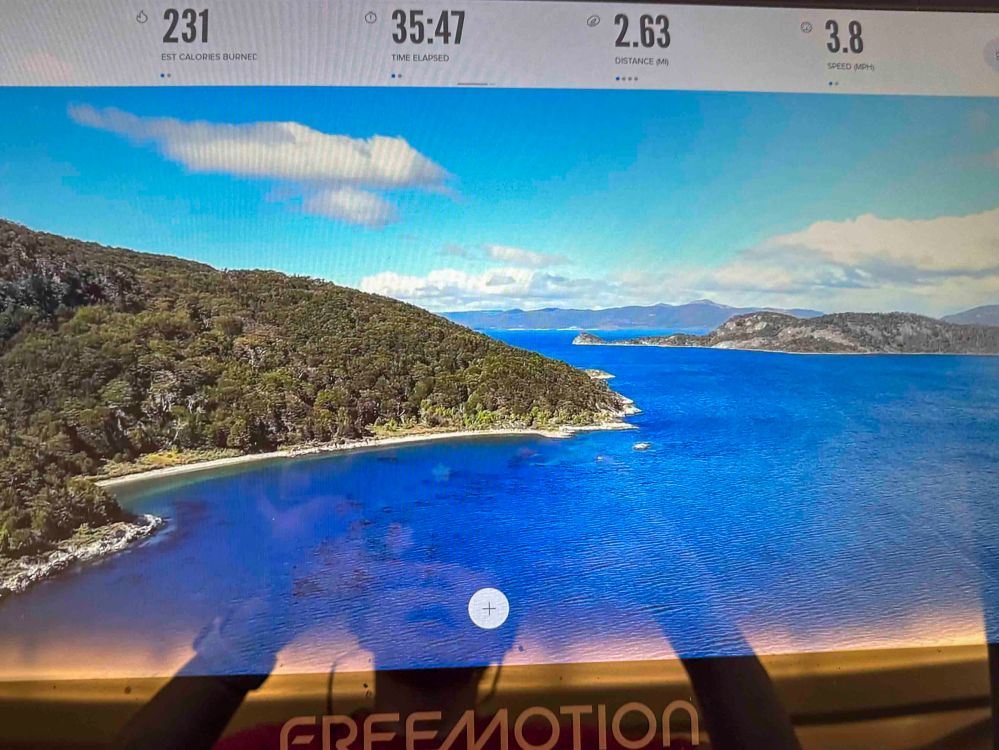
パタゴニアは南アメリカの南緯40度以南の土地を指した総称です。だからチリとアルゼンチンの両国にまたがっています。 Patagonia is the general term for the land south of the southern 40 degrees in South America. So it straddles both Chile and Argentina.
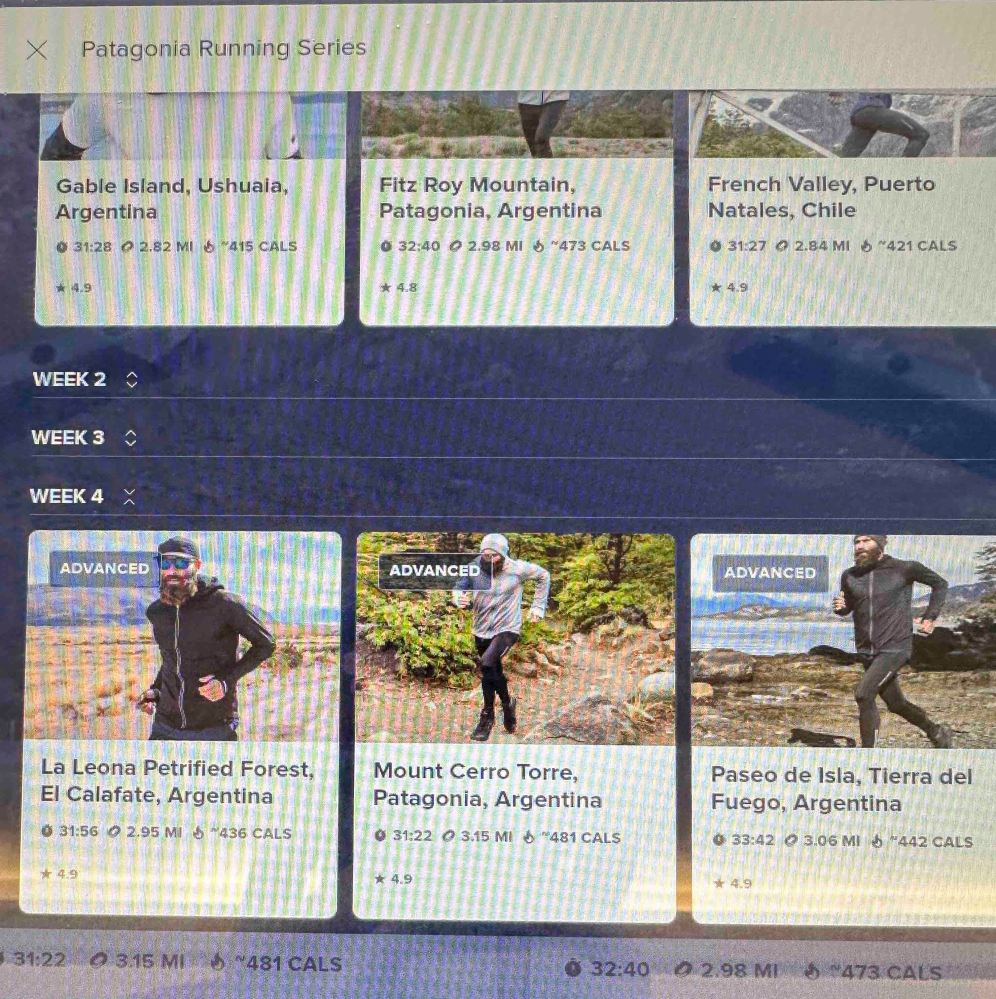
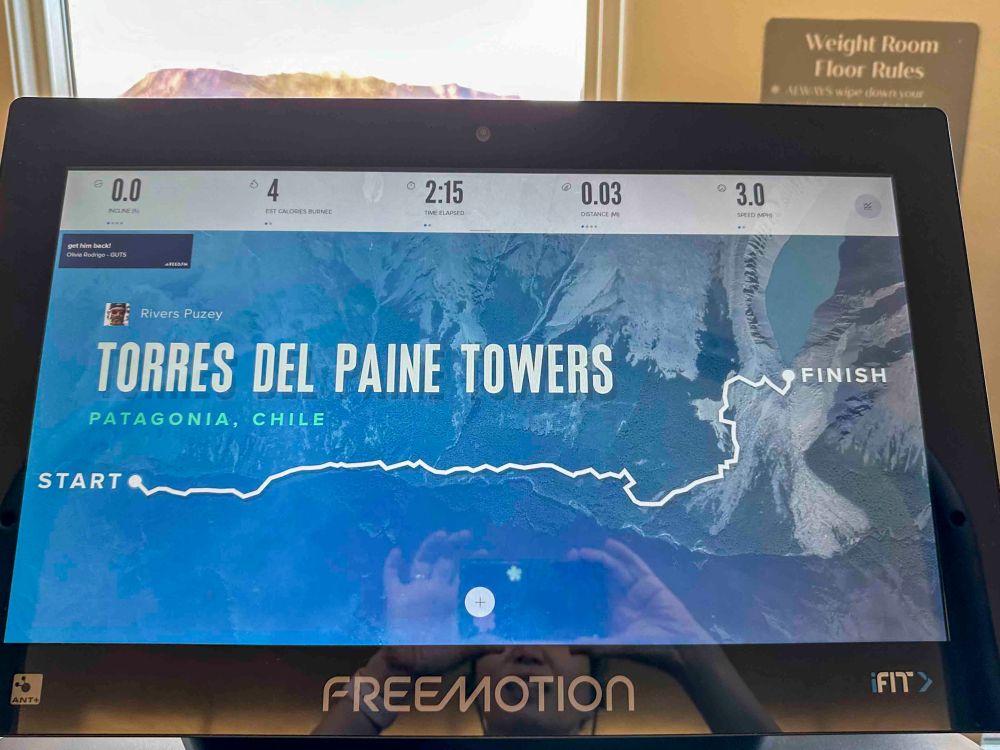
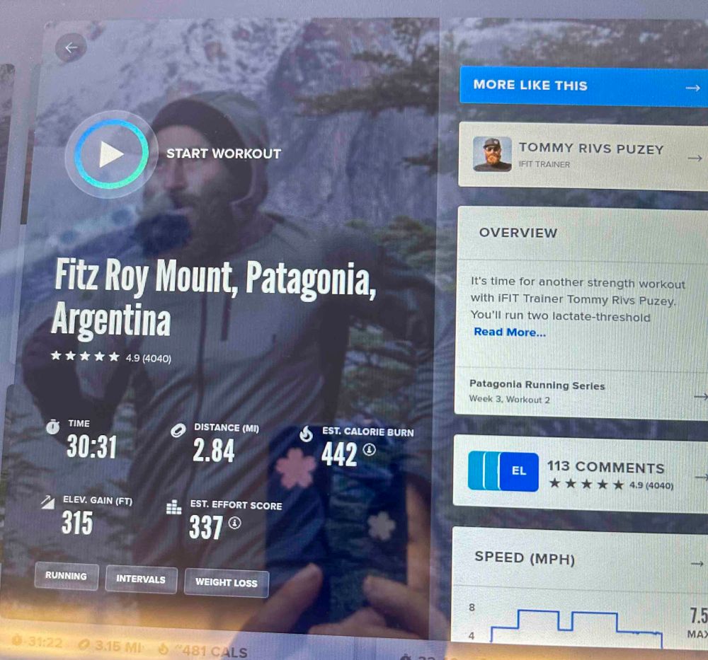
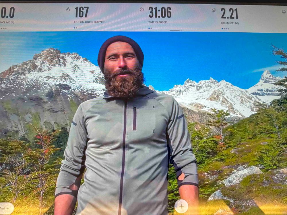
もう3週間以上前になりますが、トレッドミルでパタゴニアを訪れ、4週間シリーズのパタゴニア ランニング プログラムを完走しました。 More than three weeks ago, I visited Patagonia on the treadmill and completed a four-week series of Patagonia Running.
ただ、2週間目ぐらいに右足の不調を感じ、それも無視して走っていたら、状況はますます悪くなってしまったようです。 However, about the second week, I felt a problem on my right leg, but ignored it, and continued running. The situation seemed to get worse.
股関節あたりが動かし方によって痛みを感じます。すでにX線検査はしてあり、骨に異常はないようです。 I feel pain around my hip joint depending on how I move it. I have already had an X-ray and there seems to be nothing wrong with the bone.
スポーツ専門の医者に会いに行きましたが、不確かな部分があるので、1週間後にMRI検査を受けることになりました。 I went to see a sports specialist, but there was some uncertainty, so I am going to have an MRI scan in a week.
かれこれ、そんな事があったので、その後、走っていません。ま、すでに体の老化は進んでいるので、無理するつもりはありません。でも、走ったり、歩いたりする事は楽しいので、ずっとしていきたいです。だからこそ今、治せるものなら治しておきたいです。 I have not been running since that happened. Well, my body is already aging, so I don’t intend to push myself too hard. But I enjoy running and walking, so I want to keep doing it. That is why I want to fix it now for sure if I can.
私達は今年の12月に行く予定でしたが、来年に延期されました。船上からの眺めだけであるなら行けそうですが、写真旅行なので、パタゴニアにも南極大陸にも上陸したいです。 We were supposed to go there this December but it has been postponed to next year. If it is just the view from the ship, we could go, but since it is a photo trip, we would like to land in Patagonia and in Antarctica.
あと20ヶ月後には動物たちにも免疫力がついて、元気な姿が見られるようになっていることを祈ります。それまでには、私の足の調子も回復させて鍛えておきます。 I hope that in another 20 months, the animals will be immune and healthy. By then, I will recover my leg and make it even stronger.