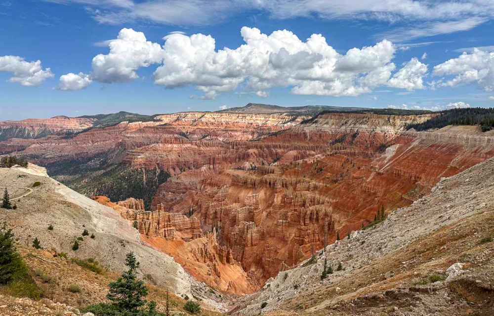
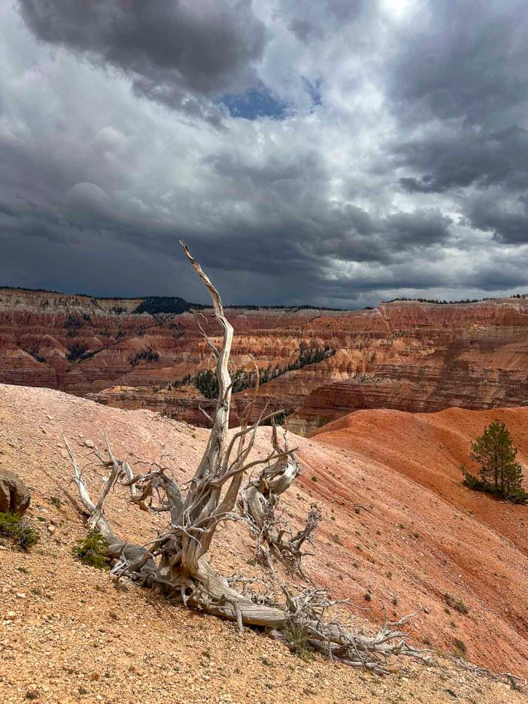
標高 10,000 フィート(3,000m) 以上、コロラド高原の西端に位置するのがシーダーブレイクス国定公園です。石灰化されたクラレン層で覆われています。 Cedar Breaks National Monument is located at an elevation of over 10,000 feet (3,000 meters) on the western edge of the Colorado Plateau. It is covered by the calcified Claron Formation.
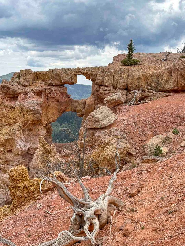
この公園の南端にあるバーティザン アーチを目指して歩き始めました。 We began walking toward the Bartizan Arch at the southern end of this park.
途中から雨が降り出したので引き返そうかと思いましたが、続行してよかったです。 It started raining partway through, so we thought about turning back, but I’m glad we kept going.
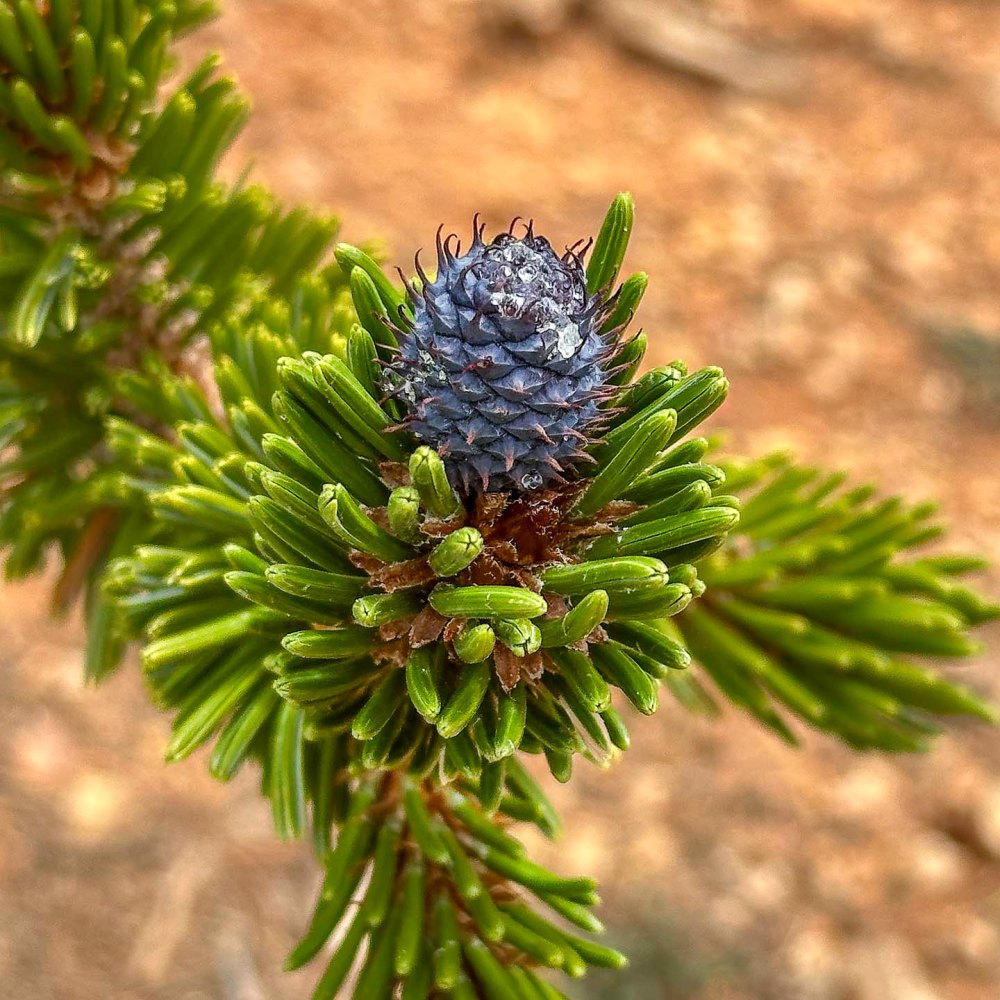
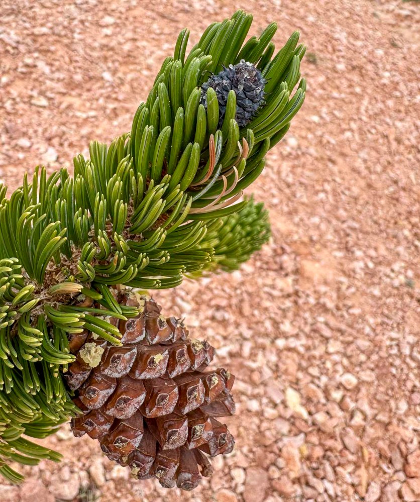
なぜなら、アーチの近くでこの青紫色の松ぼっくりに再会できたからです。ブリスタルコーンパインのコーン。 Because we were able to reunite with this blue-purple pinecone near the arch. The cone of the bristlecone pine tree.
10年前にカリフォルニアのホワイトマウンテン (14,252 ft, 4,344m) 、凍える寒さの中で初めて出会いました。その後、また会えることはないと思っていたので、ここで再開できたことは、とんでもなく意外で嬉しいご褒美でした。 Ten years ago, I first found it in the freezing cold on California’s White Mountain (14,252 ft, 4,344m). I never thought I’d see it again, so it was a completely unexpected delightful reward to see it here once more.
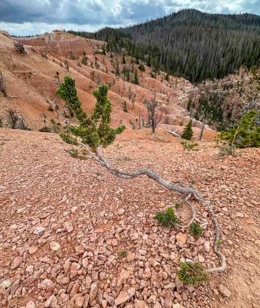
こんなにヒョロヒョロとして頼りない枝の先で頑張って生きていました。ブリスタルコーンという名前は硬い毛でできているボトルブラシのような形からきているようです。 It was struggling to survive on the tip of such a spindly, flimsy branch. The name “Bristlecone” seems to come from its bottlebrush-like shape made of stiff hairs.
青く硬いコーンは、上の写真のように2年かけて茶色のコーンに成長します。 The snall blue, hard cone grows into the larger brown cone over two years, as shown in the photo above.
石灰質の粗悪な地質、そして強風と寒さの中を生き抜いてきたブリスタルコーンの丘は、時間が止まったようにゆっくりと流れています。だからでしょうか。4000年以上も生き続けている木もあるということです。 The hills of bristlecone pines, having survived in poor limestone soil and enduring fierce winds and cold, seem to flow as if time has stopped. I wonder, is that why? Some trees have lived for over 4,000 years, like some in the White Mountains.
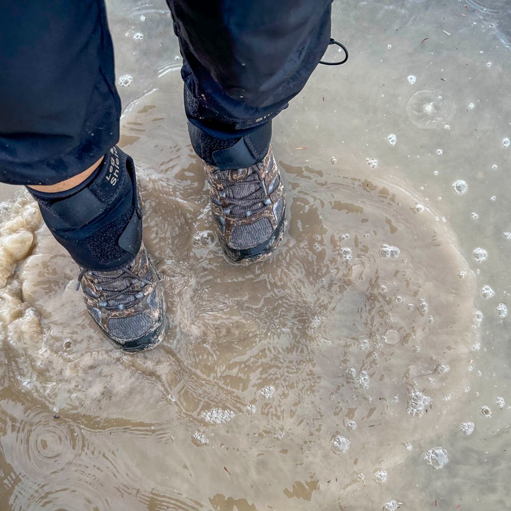
雨の中、一歩足を踏み込むたびに石灰の泥が登山靴にくっ付いて、久しぶりに泥まみれのハイクとなりました。車に乗る前、水たまりで靴を洗っているところ。 In the rain, with every step I took, chalky mud stuck to my hiking boots, making it a muddy hike for the first time in ages. Here I am washing my boots in a puddle before getting in the car.
12マイル (19.5 km)、徒歩での 自己最長記録ができました。 I set a new personal walking distance record of 12 miles (19.5 km).
家を出発して、近くの州立公園まで行って帰ってくるコースです。 The course started from home, went to the nearby state park and returned.
公園には南入り口から入り、北入り口近くの駐車場まで行きました。 I entered the park from the south entrance and walked to the parking lot near the north entrance.
ここは、10Kランのスタート地点でもありました。 This parking lot was also the starting point for the 10K run.
懐かしさと雄大な景色とで、単純に嬉しくて道で行き交う人たちとも話が弾みました。 The combination of nostalgia and the magnificent scenery made me simply happy, and I found myself happily talking to people I passed on the street.
こんな景色を見ながら、もうすっかり私のホームグラウンドになっているんだと自覚しました。 Looking at this view, I realized that this has now become my home ground.
美しい景色は疲れを忘れさせてくれますが、流石に公園を出た頃から疲れが出て来ました。休憩なしで歩きましたからね。 The beautiful scenery made me forget my tiredness, but as soon as I left the park, I started to feel tired because I had been walking without taking a break.
ロードランナーが私の前を走って励ましてくれたおかげで、なんとか家にたどり着く事ができました。 With the help of my friend, the Roadrunner, who ran ahead of me and encouraged me, I managed to make it home.
その後、トレーナーにこの偉業を誇らしげ伝えたら、護身用にペッパージェルを持って行きなさいと、1本いただきました。 Afterwards, I proudly told my trainer about my accomplishment, and she gave me a bottle of pepper gel to carry with me for self-defense.
山道じゃないから一人歩きでも大丈夫と思うのは軽率かもしれません。用心した方がいいですよね。さて、どうやって使うのかな? It may be reckless to think that it’s okay to walk alone because it’s not a mountain path. It’s better to be cautious. Now, how do I use it?
年明けとはいえ、急激に何かを始めるといいことはないというお話です。 Even though it is the beginning of the year, I am going to talk about the fact that it is not a good idea to start something rapidly.
思い立って、車で行くと11分の所にある Tuacahn Amphitheatre という野外劇場に歩いて行ってきました。Appleマップでは片道95分、往復3時間10分と出ていたので、足慣らしにはちょうどいい距離です。 On the spur of the moment, I walked to Tuacahn Amphitheatre alone. It’s only 11 minutes away by car, which Apple Maps said would take 95 minutes one way and 3 hours and 10 minutes round trip to walk, so it was a good distance to get my feet wet.
去年、バンちゃんと私は歩行距離を伸ばしていき、11マイル(17.7km)歩いても問題ないところまで体力を鍛えていました。が、年末とあってしばらく休んでいました。 Last year, Banchan and I had increased our walking distance and built up our fitness to the point where we could walk 11 miles (17.7 km) without any problems. However, I took a break for a while because it was the end of the year.
しばらくぶりの運動に気持ちがいい。クラブハウスの前のサグワロはもう春を待ちきれず花を咲かせる準備に取り掛かっていました。 It felt good to exercise for the first time in a while. The saguaro in front of the clubhouse was already getting ready to bloom, unable to wait for spring.
アスファルト上を歩いたり走ったりする事を考えて、ランニング用の靴を履きました。今から考えると、それが裏目に出ていたかもしれないと思っています。 I wore running shoes, thinking about walking and maybe running on asphalt. In hindsight, I think that may have backfired.
走る練習をしていた時に使っていトレイルを歩き始めたら、びっくりです。クラブの敷地の境界線ギリギリまで巨大なリゾート施設が建設中だったんです。 When I started walking on the trail I used to use for running practice, I was surprised. A huge resort complex was being built right up to the very edge of the club’s property line.
溶岩流跡が広がって、何もなかったところがPGAゴルフトーナメントをホストする、巨大なリゾートに変化してしまったのです。賛否両論ですが、ちょっと悲しいです。 The lava flow which had spread widely over the area have now transformed into a huge resort that hosts PGA golf tournaments. To me it’s a bit sad though.
気を取り直して、どんどん歩いて2マイルを歩いた頃から右の足の付け根が徐々に痛くなって来ました。あー、そうだったと、関節唇(かんせつしん)の損傷があったので走ることを辞めていたことを思い出しました。 I regained my spirit and walked more and more, and after walking two miles, my hip joint on my right side began to gradually ache. Oh, that’s right, I remembered that I had stopped running because of the damage to my labrum articularis.
ここで引き返しても良かったのですが、そのうちに治ると根拠のない自信があり、歩き続けました。上り坂ではありますが、大したことはなかったです。1マイル20分のペースで無事、劇場の入り口に辿り着きました。 I could have turned around at this point, but I had confidence that I would recover along the way, so I kept walking. It was uphill, but no big deal; I made it to the entrance of the theater safely at a pace of 20 minutes per mile.
かつて、この劇場でボランティアをしていた事があったので、舞台裏の方まで知っています。馬に新年のご挨拶をして、パドレキャニオンというトレイルの入り口も左に見て、劇場を去るころには痛みがかなりひどくなっていました。 I used to volunteer at this theater, so I even know the backstage area. I wished the horses a Happy New Year and also saw the entrance to the Padre Canyon trail, to the left, and by the time I left the theater, the pain was getting much worse.
5マイルを過ぎたころ、走ってみたらどうなるのだろう。早く帰れることになるわけだしと思いつき、走り始めました。もちろんゆっくりです。 After five miles, I wondered what would happen if I ran. I figured it would mean I would be able to get home faster, so I started running. Slowly, of course.
そうしたら、なんと奇跡です。痛みが消えました。そのかわり、一気に心拍数は上がり、汗がどっと出て来て、走っていた時の感覚が蘇って来ました。気持ちがいい。 Then, what a miracle. The pain disappeared. In turn, my heart rate increased all at once, sweat came pouring out of me, and the sensation of running came back. It felt so good.
ところが、今度は左足の甲が痛くなってきました。家に着く前の最後の登り坂、息が苦しいのではなく、甲の痛みに苦しい思いをしました。 This time, however, the instep of my left foot began to hurt. On the last uphill climb before reaching home, I suffered not from breathlessness but from the pain in the instep.
徒歩5.87マイル(9.45km)、ラン2.3マイル(3.7km)、トータル8.17マイル(13km) Walk 5.87 miles (9.45 km), Run 2.3 miles (3.7 km), Total 8.17 miles (13 km)
早速シャワー、足のマッサージ、筋肉痛のクリームなどを塗ったら治ったみたいです。 A quick shower, foot massage, and muscle pain cream seemed to cure the problem.
その後、色々調べた結果、私の痛みの原因は急激な運動と以下の3点に起因しているようです。 After much research, it seems that my pain was caused by rapid exercise, and the following three factors.
しばらく筋トレをしていなかった。 I hadn’t done any workout for a while.
平らなアスファルトだからとたかを括り、ストレッチせず手抜きをした。 I cut corners and didn’t stretch, thinking it was just flat asphalt.
左足の親指が靴の先にあたっていたので、親指をかばうように曲げていた。 My left big toe was hitting the tip of my shoe, so I curled it in to protect it.
いい教訓となりました。 It was a good lesson learned.
アメリカドクトカゲ:野生動物保護の会の展示場にて。 Gila monster: at the Wildlife Refuge’s exhibit.
今年は体力作りの年。そして、往復14.5マイル (23.3km) のコロブアーチ登山を1日で達成したい。また、私の5年越しの目標、アメリカドクトカゲに出会う。そのためには、歩き回ることしかありません。 This is the year of fitness. And I want to accomplish the 14.5 mile (23.3km) round trip Kolob Arch hike in one day. Also, my goal over the past 5 years, is to see a Gila monster. The only way to achieve this is to walk around a lot.
ザイオン国立公園に向かう途中に必ず目撃するゴツゴツとした岩山は、ワシが住む岩山として知られています。 The craggy rocky mountains that you are sure to see on your way to Zion National Park are known as Eagle Crags.
距離は9.5km、標高差は368m。ゴツゴツとした岩場を登っていきました。 The hiking distance was 5.85 km and the elevation gain was 1,200 feet. We climbed up rugged, rocky terrain.
ザイオン国立公園の岩山を眺める場所で休憩です。 We took a break at a place with a view of the rocky looking mountains of Zion National Park.
ハイクリーダーが、その後、ますます険しくなる道のりを説明しているところです。 The hike leader explained to us about the increasingly rugged path from then on.
結局、この岩の麓まで登り、引き返してきました。ここから先はまさに岩登りになるからです。 In the end, we climbed up to the foot of this rock and turned around, because from this point onward, it would be a difficult rock climb needing ropes.
もう夏かと思わせる暑さで、野草は嬉しそうでした。It was so hot that one would think it was already summer. The wildflowers looked happy.
昨日の午後、久しぶりの日差しが嬉しくて、スノーキャニオン州立公園に出かけました。 Being so happy to see sunshine after a long time, we went to Snow Canyon State Park yesterday afternoon.
2kg以上ある重いレンズを2本担いで8.3km歩いたので少々疲れましたが、疲れを吹き飛ばすほど嬉しい事がありました。 I was a little tired after walking 8.3 km carrying two heavy lenses weighing more than 2 kg, but there was something that made me so happy that it blew away my fatigue.
その理由は、ムナジロミソサザイに出会えたからです。 The reason for this is that I was able to see Canyon Wrens.
コロラド川沿いのリーズフェリーを訪れた時、一羽を発見して追いかけましたが、雨が降ってきて、いい質の写真が撮れませんでした。 When I visited Lees Ferry along the Colorado River, I spotted one and chased it, but it started raining and I was unable to get a good quality photo.
可愛いでしょ?目下、一番好きな鳥です。 Aren’t they cute? They are my favorite birds at the moment.
でも、翼を広げても17.5cmぐらい、14グラムしかない小さな鳥で、見つけるのは至難の業です。 But it is a small bird, measuring only about 7 inches with its wings spread, and weighing only 0.5oz. It is extremely difficult to spot.
ただ、そんなに小さい鳥なのに、鳴き声はとても大きくて、渓谷に響き渡ります。その鳴き声を頼りに、声の方に歩いて行き、飛んで来そうな岩壁を見つめてじっと待ちました。But for such a small bird, its cry is very loud and echoed through the canyon. We walked toward the voice with the call as our guide and waited patiently, staring at the rock wall where it was about to fly to.
ひとしきり美しく鳴いた後、更に高い岩壁の方に飛び去って行きました。 After beautiful singing and chirping, they flew away toward the higher rock walls.
トレッドミルを使った仮想登山です。テヘッ! This is a virtual hike with a treadmill. Why not?!
私の使っているトレッドミルのプログラムは、富士宮ルートを歩きます。4.3kmを7回に分け、1回分を20分から25分ぐらいにしています。 The treadmill program I use lets me walk the Fujinomiya route, which is 4.3 km divided into 7 parts, each part lasting about 20 to 25 minutes.
私は、2日間に分けて登頂完了しました。
パート1のスタート画面の写真を撮り損ったので、その代わりにこ結果画面です。 I forgot to take a picture of the start screen of part 1, so here is the result screen instead.
歩きはじめということもあり、上りがなだらかで、ちょっと気抜けしてしまいました。だからスピードをアップして歩きました。 Since it was the beginning of the walk, the uphill was gentle and I was a bit disappointed. So I changed to a faster speed.
パート2のスタートの画面。 Screen shot of the start of part 2.
パート2になると、突然勾配が30%と急上昇し、トレッドミルの上を歩くのもちょっと危ない程になりました。ここがバーチャルのいいところで、自分で勾配を変えられます。20%から10%、最後の方では8%ぐらいで歩いてました。 In part 2, the gradient suddenly spiked to 30%, making it a bit dangerous to walk on the treadmill. This is the nice thing about virtual, you can change the gradient yourself, from 20% to 10%, and towards the end I was walking at about 8%.
パート3。 Part 3.
パート3でも高度をたくさん稼いだことになります。 I gained a lot of virtual altitude in part 3. This is actually the case for parts 2 to the end.
わかったことは、時間が一定なので、スピードを上げても早く着く訳ではなく、距離を稼ぐだけだということです。だからスピードも勾配もプログラム通りにしておく方がいいです。 What I found out is that since the time is constant, increasing the speed will not get you there faster, it will only increase the distance. So it is better to keep both speed and gradient as programmed.
多くの人たちは、富士宮ルートの5合目から頂上までの4.3kmを4-5時間ぐらいで登るらしいです。標高が 2,400m から 3,776m まであるので早く歩くわけにはいかないんですね。 Most people climb the Fujinomiya route from the fifth station to the top, a distance of 4.3 km, in about 4-5 hours. The altitude ranges from 2,400 to 3,776 meters, so it is not possible for a normal person to walk fast.
もう20年以上前のことですが、私も富士山頂まで息子と二人で登りました。このルートではなかったと思いますが、二人とも高山病になってしまい、下山するまで苦しみました。 More than 20 years ago, my son and I hiked to the top. I don’t think it was this route, but we both got altitude sickness and suffered until we descended.
—
二日目。残りのパート4から7までを歩き、無事、頂上に立つ事ができました。へへッ! Second day. I walked the remaining parts 4 to 7 and successfully made it to the top. Grin.
パート4。Part 4.
このパートでも高度を稼ぎましたが、トレッドミルの勾配数を変えずに歩いてみました。 I gained altitude again in this part, but walked without changing the default gradient on the treadmill this day.
パート5のスタート。 Part 5.
勾配が30%もあると、それだけで汗ダラダラになります。 With a slope of 30%, it is enough to make you sweat a lot.
結構疲れてきていたためか、パート6のスタート画面を撮り忘れました。 Perhaps because I was getting quite tired, I forgot to take a picture of the start screen for part 6.
パート7のスタート。 Part 7.
頂上の火口近くなので、ここまでくると登りはそれほどなくなりました。 Since I was near the crater at the summit, there was not much more climbing to do up here.
30%の急勾配を歩いている最中に、「エベレストでも目指してるの?」なんて言われました。 As I was walking up the steep 30% grade, someone asked me, “Are you aiming for Mount Everest?”
アイディアいただきです。次回はエベレストに挑戦もできる! Thank you for the idea. Next time I can try for Everest!
雨が降る日には、仮想登山、楽しいです。 On rainy days, it’s fun to do a virtual hike.
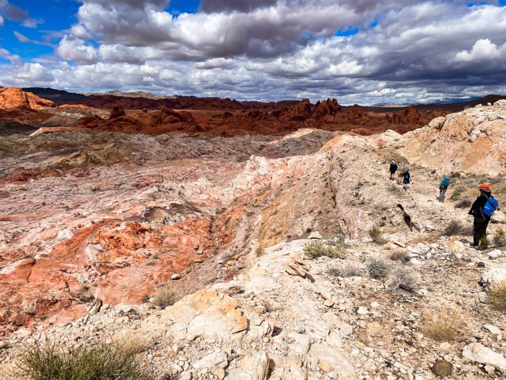
距離は10km、325mの標高差、アリゾナ州のバレーオブファイヤー州立公園内のピナクルズループは今回で2度目ですが、雨が降ったばかりのためか、景色がとても違って見えました。6.2 miles with 1,066 feet total climbing. We have been here once before, but Pinnacles loop at Valley of Fire in Arizona looked different. The rain the day before might be why.
歩き始めて程なく見えてくる景色。 This is the sight you could see after a short hike of half an hour or so.
もう、っこの日の目的は終わり、帰っても良いと思えるほどの絶景。 It was such a stunning view that I could have just gone home after seeing that.
実際、ほとんどの人たちが、この先に足を踏み入れません。 In fact, most visitors to the park stop right there and don’t go any farther.
なぜなら、その先はトレイルもないし、荒野があるだけだからです。 It’s because there is only wilderness beyond there without any trail.
私たちは、本当にラッキーです。なぜなら、私たちのハイクリーダーのジョンは私たちだけでは絶対行けない所まで連れて行ってくれるからです。 We are really lucky to have our hike leader. He could take us places where we could never get to on our own.
ハイクリーダーのジョンはチェスターという犬をよく連れてきます。Our hike leader, John, takes Chester out often on our hikes.
彼の大家さんの犬ですが、彼の犬のように懐いています。私たちも彼のリードに従って歩くので、チェスターのようにジョンに懐いていると言えないこともありません。 Chester is John’s landlord’s dog, but he is attached to John and follows him everywhere. Come to think of it, we also trust John and follow John’s instruction. Are we attached to John like dogs?
目指すは、ピナクルズと名付けられた場所。ギザギザの岩山が中央、奥に見えます。 Our destination was the Pinnacles where the pointy peaks are in the picture below.
迫ってきました。 It’s getting closer.
雨上がりなので、水たまりがたくさんあり、避けながら進むので、さすがのジョンも四つ這いになって崖の横を進みました。 Even John needed to get down on all fours. The recent rain created many ponds and we had to work our way around them.
ピナクルの真っ只中、景色は最高で、どのショットを見直しても捨て難いものばかりです。 All my shots from the Pinnacles are so good that it was very difficult to choose which to include in this blog.
こんな所まで来られたのが嘘のようです。 It’s hard to believe that we made it there.
ピナクルを通り抜け切る前にランチ休憩。 We had a short lunch break before leaving the Pinnacles.
ピナクルの向こう側の景色は再び変わり、赤い岩肌が見えてきます。 The other side of the Pinnacles had different views. It changed to red rocks.
雄大な自然、これこそがアメリカのアセットです。 Majestic great nature, it’s one of the greatest assets of America.
満足のハイク、ハイクリーダーに感謝、自然に感謝、私達の健康にも感謝です。 I was quite satisfied with the hike, and thankful for our hike leader, nature, and our health.
14.5kmと距離もあり、標高差915m、しかも山道もない場所、難易度の高いハイキングでしたが、景色は最高でした。 The total hiking distance was 9 miles, 3000 feet altitude changes, and mostly off-trail. The difficulty level of the hike was was hard, but the view was incredible.
ヤントフラットからスタートから1時間後の景色です。 After walking from the Yant flat trailhead for one hour, the view opened before us like this.
これから先の場所を確認しています。 The hike leader explained to us the rough direction where we were heading.
ここから岩壁を降り、登り、そしてまた登りと繰り返しました。 We then went up and down, and up and down the rocky wall.
蜘蛛のように四つ這いになってよじ登り、ズルズルとお尻で降りてくるような場所でした。 We crawled up on the rock literally like spiders, and slid down with our butts.
日陰で見た鮮やかでビロードのような苔。真夏は茶色っぽいのに、水をもらうと復活するレザレクションモスです。 I saw vivid and gorgeous velvety moss at shady rocks. It’s resurrection moss. Although they look brownish when dry, they become like this once they get water.
日向ではすでに1cmしかない野草が咲いていました。真夏の暑い時には冬眠ならぬ、夏眠をするのでしょうか。 I saw these tiny flowers already blooming under the sun. I wonder if they hibernate during the hot summer?
超えてきた場所を振り返ります。あの巨岩群を超えてきたのかと思うと、感無量です。 This is the view of the rocky mountains where we walked through. An intense feeling of fulfillment came to me while looking back at them.
さて、ここからです。半分以上歩いたものの、ここからが難所でした。溶岩石の間を降りていくのは、このハイクの中で一番苦しく、また危険な場所でした。Now, the toughest part of the hike started from here at the last one third of the entire walk. It was the most dangerous part of the hike going through the lava rocks especially since we were quite tired already.
そして、7時間後、ようやく見えたゾウのアーチです。そこから駐車場までは40分ぐらい。 Here is Elephant Arch that we wanted to see. After 7 hours of hiking, we could see it, but it took only 40 minutes to get to the parking lot from there.
ドライブ時間も含めると、朝7時半から夜7時半までかかったハイキング。さすがに疲れてしまい、その夜はぐっすり眠ることができました。 We left home at 7:30 am and got back home at 7:30pm. What a hike it was. As expected, we were so tired and slept very well that night.
フィットネスセンターのトレッドミルは優れものです。 The treadmill at our fitness center is a wise machine.
自分でワークアウトを作ることが出来ます。そこで、さっそく作ってみました。 One of the features allows you to make your own workout. So I tried it.
コロブキャニオンズでハイキングができなかったので、そこを歩きたい。スタート地点と終了地点を地図上に入力すると、私のワークアウトが本当にできちゃいました。 My workout was in Kolob Canyons because we couldn’t hike there the other day. By entering the starting point and ending point on the map I could make my own workout that simulates this hiking course. Wow!
写真も可能な限り映し出してくれて、傾斜もコースに沿って作ってくれる。 It gave me images along the course. Not everywhere, but at some points along the route.
そうそう、去年このキャンプ場まで歩いて、引き返したんです。 My memory came back. We hiked up to the campground at the bend on the map below last year.
ここから先は未知の世界。ルンルンと歩いていら、55分を切った時点でクールダウンになってしまいました。 I don’t know beyond that point, it is an unknown world. I was so happy with this cool feature of the treadmill, but it suddenly switched to cooldown mode when it reached 55 minutes.
「優れ物」を撤回、かなり残念です。 I was so disappointed. I will take back my word, “wise machine”.
仕方がないので、もう一度やり直しました。 I tried to continue the course, but couldn’t. So I started it again reluctantly.
今度はテレビを見ながら走ったり、歩いたりのインターバルをしました。This time, I did walking and running intervals while watching TV.
コロブアーチまで7マイルm、11.25kmです。それを往復するので14マイル。この日のトレッドミルを4回繰り返すと完了する事になります。でも、実際は6-10時間だと言われています。標高2000メートル以上の場所ですから、それを考慮すると、走れませんよね。 It’s 7 miles to get to Kolob Arch, which is our goal. And the round trip is 14 miles. If I repeat the same workout 4 times, I could get to the arch and come back based on my calculation. But it’s been said it takes 6 -10 hours. The real trail is above 7000 feet. I guess we can’t run there like I do here at 3000 feet.
仮想ハイクは、行きたくてもいけない場所でハイキングの擬似体験をさせてくれます。1時間以内で歩ける距離なら、楽しいでしょう。 It’s fun exercising with a virtual hike if you can make a course finishing in less than one hour, especially at the places where you want to go, but you can’t.
週末、今年7番目のハイキングをするためにザイオン国立公園のコロブキャニオンズ地区に行きました。 We went to Kolob Canyons district of Zion National Park last weekend to do the 7th hike of this year.
雪と氷を全く予想していなかったので、トレイル入口で断念しました。標高2000m以上はまだ冬。アイゼンやストックを持って行けば、さぞかし楽しいハイクができたことでしょう。 We didn’t even think about ice and snow, but there it was. So we gave up at the trail entrance as we didn’t bring crampons and hiking sticks. The elevation, over 7,000 ft, was still very much in winter.
車で65kmも走ってきたので諦めきれず、近くの町のスプリングクリークというトレイルに向かいました。 We felt we had to do some hike since we drove 40 miles to get there. So went to near-by Spring Creek trail.
比較的平らなので、多少の登りや下りはあっても、気をつけて歩けば雪道も怖くないと思ったからです。 We thought the snow covered trail wasn’t that bad as long as we walked carefully because the trail was rather flat.
しばら歩いていくと、一歩踏み込んだ時の靴音が違うのに気づきました。 We noticed that the sound from under our boots was different after a while.
これは、もしかして、いや、まさに、小川の上を歩いていた!!! We were possibly… let me rephrase it, we were absolutely walking on a river!!!
橋の上を歩くと聞こえる太鼓を叩くような音。気がついたら、小川のせせらぎが聞こえていました。氷の橋だ! The sound I heard was very similar to the sound that we could hear when we walk on a bridge. Then, I noticed the sound of the creek. It was an ice bridge!
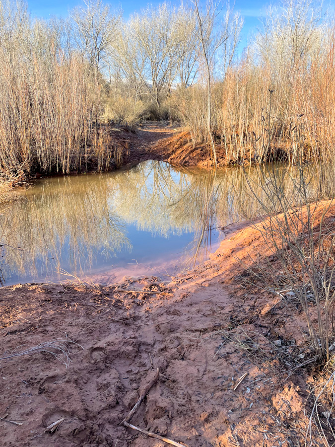
さらにいつくかの小さな氷の橋を渡り、気分も爽やかでしたが、1.5kmぐらい歩いた所でガリー(深い谷)に遭遇し、断念しました。 I felt so good walking on the snow and crossing a few more ice bridges. But then, we needed to give up at 1 mile because a deep gully full of thick mud was ahead of us.
10kmぐらい歩きたいと思っていたのに、3kmしか歩けませんでした。でも、初めて氷の橋を渡ることができたから、ラッキー。 We wanted to hike longer than 6 miles, but it was only less than 2 miles. But that’s all right. We could walk over ice bridges which I have never done before!
Note: “Enepitsi” (pronounced e’noo petes) means “ghost” in the Southern Paiute language. Ancestral Puebloans and Southern Paiutes lived in this area and are closely connected to the land.
サンタクララ川沿いを歩く、6.5km ほどの短いハイクでした。 It was a short hike of 4 miles walking along the Santa Clara river.
ハイクリーダーが寝坊してしまったので、リーダーなしで出発しました。 We started the hike without our hike leader because he overslept.
道がわからず歩いていくと、川にぶつかり、先に進めません。 At one point, the trail split and we weren’t quite sure which path to take. So we went left, but ended up hitting the river and couldn’t go any farther.
引き返して別ルートを歩いていくと、石に刻まれたペトログリフを発見した時には安堵しました。 ペトログリフを発見するのが目的でしたから。So we went back to the split and took the path to the right instead. When we found petroglyphs on rocks, I was so relieved because one of the purposes of the hike was to see some petroglyphs.
このトレイルの名前が「幽霊」なので、それにまつわる絵が刻まれているのでしょうか。 I wonder if any images related to “ghosts” were there because of the name of the trail.
やはりコースを知っているリーダーの存在は偉大だと思いました。 I thought the presence of the hike leader who knows the trail is indeed important.
早朝、日の出前、ザイオン国立公園に行く途中にある町、ロックビルにあるフーバーウォシュというトレイルに向かい出発しました。マイナス6℃。寒い! We left home before sunrise and headed to the Huber Wash trailhead outside of Rockvile near Zion National Park. It was 21°F, and so cold!
氷点下で寒かったんですが、トレイルの砂が凍っていたので、その意味では歩きやすかったです。Because it was below freezing, the ground on the trail, made up of sand and mud, was frozen. So, from that sense, it was easy to walk on.
氷や雪の上は滑らないように注意して歩きます。 We walked carefully on the ice and snow.
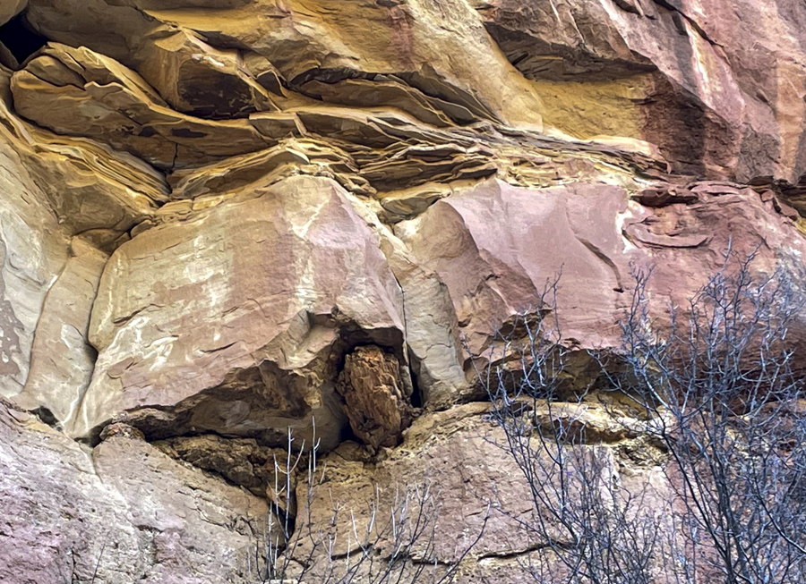
私たちの目指したものは、三畳紀の頃の化石化した木です。写真の質が悪いので見えにくいんですが、以下の写真中央に見えます。 Our goal was to get to a place known as the petrified log jam in sediments from the Triassic period. The pictures below aren’t good quality and not so well captured but you can see them at the center of the pictures.
トレイルの終点では、予想外のものを発見。つららが岩の下から下がっていました。 At the end of the trail, we found unexpected things. Many icicles were hanging down from the over-hanging rock.
チンリ層独特の粘度質の薄緑色の地層を伝って下がっているので、なんとなくみど色っぽい。 They looked rather lime colored. My guess is that the water trickled down through the Chinle formation clay which is lime color.
そして、なんとポタリポタリと雫が落下している着地点を見ると、氷のビー玉ができていました。 And it was even more interesting that many ice marbles were formed on the ground below by drops coming from the icicles right above them.
わー、面白い。 How interesting nature’s creations are!
手袋をしても指がちぎれそうに寒かった日でしたが、往復9km のユニークなハイクでした。 It was so cold that my fingers were painful even with gloves, but it was quite a unique 5.5 mile round trip hike.