Tag Archives: ハイキング

Hike 14: Falling Man


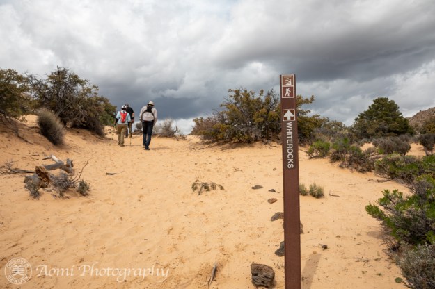
ネバダ州のゴールドビュート国定公園、4km と、とても短い距離ですが、4時間かけて岩場を歩く盛りだくさんのペトログリフ巡りをするハイキングでした。 The hike route was only 2.5 miles, but we spent more than four hours going through the rocky area at Gold Butte National Monument in Nevada. This was because there were petroglyphs everywhere.

説明し出すととても長くなります。だから要点だけをまとめます。アメリカ先住民によって描かれたペトログリフは、古いものは1万年前、新しいものはほんの数百年前のものまである様です。その見分け方は、岩の色、点描画のように、一点一点削られた後の色などで判断されるようです。 This is a very short summary of what I learned yesterday. The petroglyphs were carved by Native Americans. The old ones are 10 thousand years old but newer ones are only 200 years old. We can’t tell clearly but we could guess the age of the petroglyphs by looking at the rock color and the lines of petroglyphs created one dot at a time.

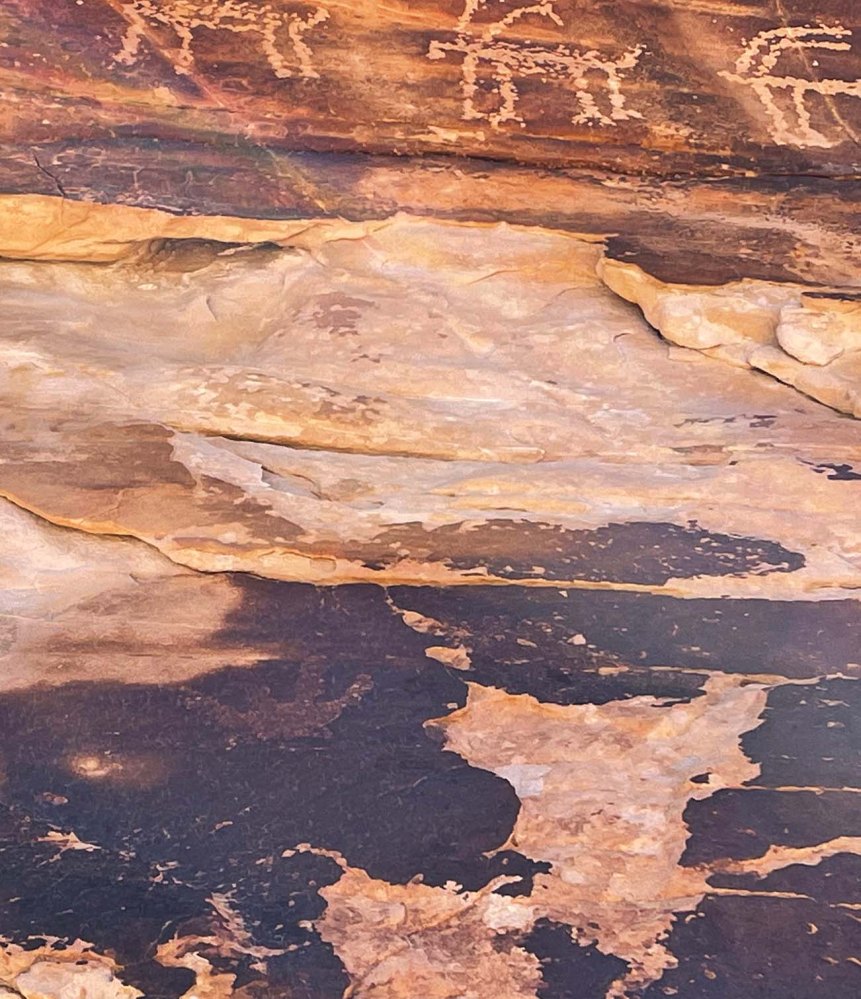
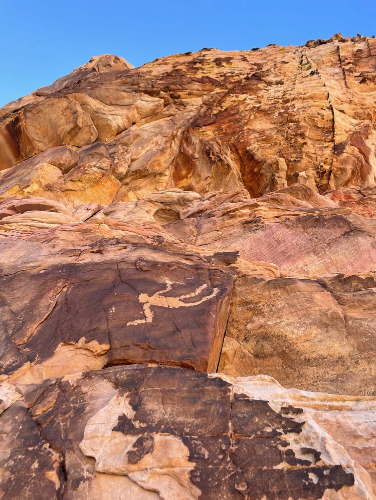
例えば以下の写真です。不鮮明ですが4本指の手が下の方に描かれています。上のヤギと比べるとペティナ(古色化)により多く覆われて、描かれた年代が古い事がわかります。 The picture below is one example. Can you see a hand with four fingers towards the bottom? It is covered by petina more, so it can tell us that the hand is older than the goats along the top.

突起する場所は3箇所です。The hike had three highlights.

  1. フォーリングマン(転落する男):ペトログリフはこの辺一体に散財しています。そのどれもがマッチ棒のような表現の仕方になっています。例えば、こんな感じ。 Falling Man: You can find so many petroglyphs at this particular area. And almost all of them are carved like stick man pictures. See below picture.

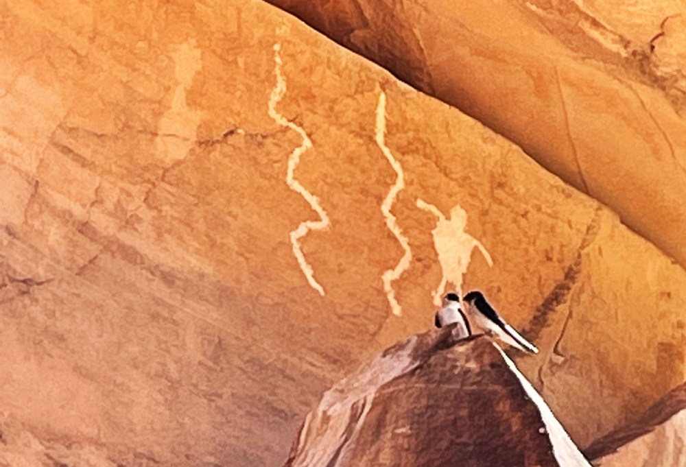
でも、ただ一つ、この絵は明らかに違いました。 However, one was clearly different.

描かれた場所から、親族、もしくは特別な誰かが高い崖の上から転落した様を伝えようとしているのではないかという事です。 正面から見たマッチ棒のような図では表現できない出来事だったので、こう描かれたのではないかということです。The location of the petroglyph is on the side of a high cliff. One theory is that someone very important to the artist had fallen down off the top of the cliff. So he/she couldn’t simply express it with a stick man figure. That caused him/her to do a totally different type of carving from the others.

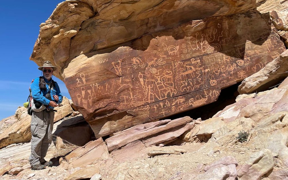
2. ニュースペーパーロック(新聞岩):ペトログリフがギッシリ積み込まれた一枚岩です。ジムブーン博士が絵について諸説を説明してくれました。 Newspaper Rock: it’s named newspaper rock because many petroglyphs are packed onto a single wall of rock. Below picture is Dr. Jim Boone who guided us to these places. He talks about several theories how we could read them.

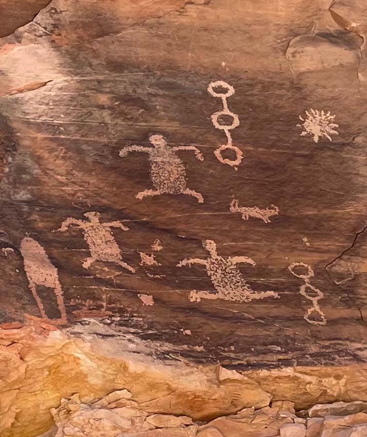
3. 21ぴきのヤギ:ちょっと疲れてきた頃、突然現れた岸壁です。みんなその壁に見入っているところです。 21 Goats: It was towards the end of the hike. We were tired, but the flat cliff face appeared suddenly in front of us. And it shocked us all.

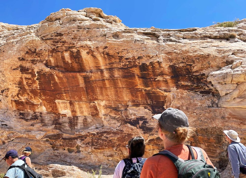
なぜなら名前の通り、やぎが21頭、もしくはそれ以上描かれていたからです。列を成してどこかに行こうとしているところなのでしょうか。This is because 21 or more goats were carved on the rock surface. I wonder where they are going all lined up like that?

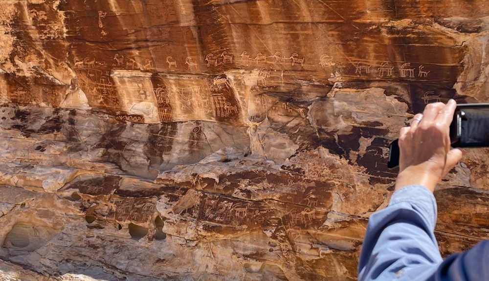
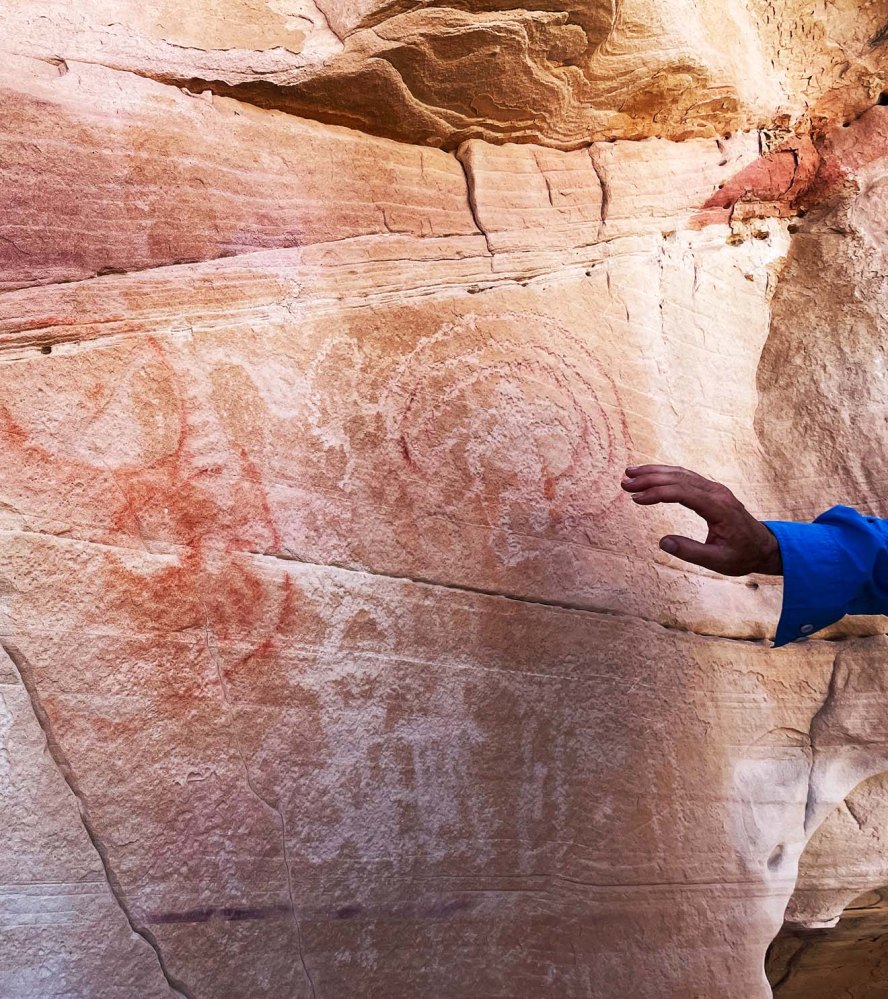
最後に、ペトログリフとペトログラフは別物である事です。ペトロは岩、グリフは彫刻、グラフは絵画です。以下の写真は、両方が混合しています。赤い線がペトログラフです。 For the last, I want to point out about the petroglyphs and petrographs. I didn’t know this, but “petro” is “rock”, and “glyph” is “carving”. And “graph” is “drawing”. The picture below includes both petroglyphs and petrographs. The red color drawings are petrographs.

Hike 12: Pushing Tin Loop


7.2km の面白い名前の道、”Pushing Tin” という道をぐるりと回って帰ってくるハイキングでした。The Pushing Tin loop is a 4.5 mile easy trail.

なぜか飛行機が次から次へと飛んでいました。We didn’t know why, but many airplanes were flying over us one after the other.

それがこの道の名前の由来になったのでしょうか。飛行機をアルミ缶に見立てて、どんどん押し込んでいく(飛ばしていく)管制官たちを描いた”Pushing Tin”という映画もあります。でも、誰も本当の理由は分かりません。 Someone said that that could be the reason for the name of the trail. There is a movie, “Pushing Tin“. It is about air traffic controllers at an airport. Their job is to push tins (airplanes) one after the other. But no one knows the true origin of the name.

タンブルウィードはコロコロと転がって、どこに行くのか考えたことがありますか? Have you ever thought about where tumbleweeds go after tumbling around?

赤ちゃんサボテンの赤い実。鳥の食べ物になるのでしょうか。We found a baby cactus with red fruits. Could they be food for birds?

春の朝、楽しい会話で一杯のハイキングでした。One spring morning, we had a conversation full of fun while we hiked.

Hike 11: Toe trail


Toe Trail は往復 5.8km 無理しないで歩ける、平らなトレイルです。 The Toe Trail is a flat and easy 3.6 mile trail.

毎日バスルームの窓から見えるレッドロックの麓を歩きます。 As you can see in the picture below, it’s very flat. Part of the trail runs right next to the bottom of the Red Rock which we see from our bathroom window everyday.

こちらが窓からの眺め。 This is the window view.

このレッドロックは二つの地層からできています。上層部がナバホ砂岩地層で、下層部がケヤンタ地層です。すごく分かりやすいですよね。 The Red Rock consists of two parts. The upper part is Navajo sandstone and the bottom is the Kayenta formation. Isn’t it easy to see the differences?

暖かくなってきたので、トカゲとかヘビとかに出会えるかなと期待しましたが、見られませんでした。でも、小鳥のさえずりが至る所から聞こえていました。それだけでも清々しかったです。 As it’s a little warmer these days, we hoped to see some lizards or snakes, but we didn’t see them. Instead, we heard little birds singing from the side of trail, and that made us feel so uplifted.

Hike 10: Shinob Kibe


Shinob Kibe は ハリケン断層ラインに立つ小高い丘です。登って降りて来ると2.5 km ほどなので、1時間もあれば帰って来られますが、興味深い歴史物が残っているので2時間ぐらい時間をかけたい。Shinob Kibe is a small mesa standing along the line of Hurricane fault. The distance is only about 1.5 miles round trip, so it takes only one hour or so. However, I recommend to spend two hours because there are interesting historical objects.

遺跡 1:”Medicine wheel“、「神聖な環」と訳しておきます。150年前に北米先住民族のパイユート部族の信仰、世界観の具現化された物です。 Historic Ruin 1: you can find a “Medicine wheel” made by Southern Paiute people around 150 years ago.

草が生い茂ってしまい、よく分かりません。ハイキングリーダーの後に私まで写っていますが、そこを中心に4-6本の線が伸びて円を描いています。ここでどんな儀式が行われていたのでしょうか。I couldn’t recognize it until our hike leader pointed it out, because plants covered the rocks in places. In the picture above, our hike leader and myself are standing at the center of the wheel. From there, lines of rocks are laid out to make a large wheel. I am now curious what kind of ceremony was held there.

遺跡 2:航空用の矢印。頂上にはコンクリートでできた大きな矢印があります。1926年にロスアンジェルスからソルトレイクシティ間のエアメールサービスが開始されました。その時に パイロットが迷子にならないように10マイル(約16km)ごとに同じ矢印が設置されました。かつては航空塔があり、そこから無数のランプを灯して光を放っていたそうです。詳しい事は、このサイトをご覧ください。 Historic Ruin 2: An Aviation Navigation Arrow is on top of the mesa. The air mail service between Los Angeles and Salt Lake City started in 1926. An arrow like this was placed every 10 miles all the way to Salt Lake to help guide the pilots. An aviation tower holding a very bright rotating beacon stood in the center of the arrow to indicate the location of the arrow in bad weather. Look at this site for the detail.

こうして歴史の勉強をして丘を下ってきたのですが、反対側の斜面の麓を見ると、なんか見覚えがあるような景色なんですね。 I was so happy learning two new historical facts before coming down the mesa. On the way to the bottom, I found something familiar at the bottom of the hill in front of me.

これはもしかして、私の5Kレースのコースかもしれない。Could it be my 5K race course?

家に帰って地図を見たら、やっぱりそうでした。バージン川を挟んで向こう側の遊歩道を走るんですね! I confirmed the course after coming back home. I will run the walking path on the other side of Virgin river!

Hike 8: La Verkin Creek Trail


8km の緩やかなハイキングコースでした。It was an easy 5 mile long trail.

ラバーキンク川の横には溶岩の崖がそびえ立っています。High cliffs of lava rocks are standing right next to the La Verkin Creek.

その崖の窪みには無数のツバメの巣がありました。We found many swallow’s nests on the wall cavities.

グループの年齢層は広くて、20歳代から70歳代まで。それでも一緒に歩いていると楽しい。みんな子供になっちゃうんでしょうか。ハイキングの魅力の一つです。The age range of our hiking group is very wide, from 20’s to 70’s. But we could enjoy being together while walking. I think that is one of nice things about going for a hike in a group.

Hike 7: Temple Quarry Trail


5.96km、88m の登り。簡単な半日ハイキングコースでした。私たちは、横道に逸れて別ルートも歩いたので、距離は少し長めです。 It is a half day hiking trail, 3.7 miles and 289 feet elevation gain. We went off on a side trail at the end, so the distance is little longer than the trail itself.

かつて使われていた飛行場を左に見ながら歩くコースです。今はレストランや学校などができてきます。この10年間、この街がいかに変わって来たのかを話しながら歩きました。The old St. George airport was on the left side of the trail. It’s now used for variety of purposes. We talked about the town and how it has changed in the past 10 years while walking.

このトレイルは石碑ができるほど由緒ある道です。写真にあるように、1871年から3年間、溶岩を切り出すために使われました。The trail has an historical background, and a monument plate was attached to a rock. According to the description, it was used to carry lava rocks from 1871 to 1874.

セイントジョージの街の中心にあるセイントジョージ寺院はモルモン教の開拓者が建立しました。その際、地盤として溶岩を使う必要がありました。The Mormon pioneers needed lava rocks for the foundation of the Saint George Temple standing in the center of town.

溶岩が必要だった理由は、この地域の土壌はアルカリ成分を多く含んでいるので、その浸透を防ぐためだと、石碑には書かれてありました。 According to the monument description, they needed to use the lava rock because the soil at the temple site is an alkali soil, and lava rock was impervious to alkali soil.

この道を切り開くためにダイナマイトが使われました。道脇には、ダイナマイトが差し込まれたであろう穴が残る石塊がまだ残っていました。The pioneers used dynamite charges to make the trail. We found rocks still containing holes for the dynamite charges on the side of the trail.

大きな機械がなかったころ、半端じゃない困難な作業だったに違いありません。Can you imagine how hard it was to carry such huge rocks down without any machinery?

でも、「不可能に立ち向かう」、それが人間の歴史でしたよね。だから宇宙にも行ける様になったんだ。思考が飛躍しました。でも、すごくない、私たち?人間万歳だ! But our history was always like that, wasn’t it? We kept challenging ourselves against impossibles, didn’t we? That’s why we could go to space. My thought leaped high from this, but, aren’t we great or what? Yes, Banzai human!

Hike 5: Power Line Point-Diamond Valley


約 4km 、1時間ちょいで終了した短い早朝ハイキングでした。手袋をしても指が凍りつきそうな寒さでした。 It was a short early morning hike that took only a little over one hour for 2.5 miles. It was so cold that my fingers could freeze even with gloves.

視界が開けると空に向かって口を開けているスコリア丘が見えました。At a viewpoint, we could see a black Cinder Cone opening its mouth towards the sky.

黒いスコリア丘が右に見えます。The black cinder cone is on the right side.

動物たちの足跡が凍りついた地面についていました。これはシカのヒズメでしょう。Because the ground was still frozen, we could see animal foot prints here and there. This must be deer’s hooves.

これはマウンテンライオンとか? Could this be a mountain lion’s?

これには鋭い爪の跡もついています。This one has two sharp claws.

Hike 2: カバの洞窟 Hippopotamus Cave


約8.5 km (5.3 miles) 700feet 標高差の簡単なハイキング。 St George の南にギャップ (Gap = 裂け目、まさに断層で亀裂が起きた部分) という場所があります。その右側をギャップに沿って歩いていくと洞窟があります。It was an easy hike, 5.3 miles and 700 feet elevation gain. You can find Hippo’s cave after a 2-3 mile walk along the Gap in St. George UT.

洞窟内部で見つけた不思議な物体。We found a strange object in the cave.

「コウモリのフンが固まった物?」「古い木の樹液?」小さなカケラを洞窟の外に持ち出して観察しましたが未だに謎です。”Could it be bat droppings?” “Or could it be old tree sap?” etc. Although we observed a piece of it outside of the cave, it’s still unknown.

ギャップの崖の上から南方の景色。今度はこの下のルートを歩きます。Looking down the southern direction from the cliff. We will be hiking the trail down below in a week.

パルヌウィープ – Parunuweap


コロナも何も関係ないほどザイオン国立公園内は混んでいました。駐車できる場所を探すのに一苦労でしたが、私たちの目指すパルヌウィープの高台への登山道に入るとすぐ喧騒は消えてしまいました。Zion National Park was already so crowded even though there are still Corona restrictions. We had a hard time finding a place to park, but it became quiet once we started walking on the trail to our destination, Parunuweap Overlook.

以下のスクリーンショットは私たちの道なき道を歩いた軌跡、標高、そして移動スピードのデータです。携帯サービスのない所にばかり行くので、サテライトに繋げられるデバイスを使い始めました。The screenshot below shows the trace of our hike, elevation, and speed of our movement. We started using a gps device that can connect to a satellite because we often go places where no cell phone services are available.

このハイキングは9時間ほど、16kmぐらいの距離を崖を登ったり降ったりと、かなりチャレンジングなものでした。でも、どこもかしこも絶景で、ザイオンの秘境を満喫し、同時に自然の美しさを謙虚に受け止めました。The hike was about 10 miles long with a lot of ups and downs on a rocky surface for about 9 hours. It was quite strenuous for me, but everywhere I looked, I found spectacular views. I humbly appreciated all of them at the secluded area of Zion NP.

ハイキングリーダーと自然が作り上げた渦。The hike leader and a Vortex.

R5 カメラがあったら、どんなに美しく撮れたことかと思うと残念ですが、私の携帯カメラでも、十分に素晴らしい絶景が撮れました。I wish I carried my R5 camera so that I could take much better shots than these. (if I carried my R5, it might be too hard to walk through the hike.) Yet, still, I could captures many nice shots.

記念に残るハイキングの一つになりました。This hike became one of my most memorable hikes in recent years.

自然の成長 – Growth of Nature


去年の山火事で、近くの山や平野が焼き尽くされました。Last year’s wildfire burned near-by hills and mountains.

その為、そこに棲息していた小動物たちも焼け死んでしまいました。Sadly, because of that, all kinds of small animals also burned.

その復興を願って去年の秋、低木を植えるボランティアをしました。その後、どんなになっているか気になっていたので行ってみました。So many local volunteers including myself joined the restoration project involving planting young native plants last Fall. I was wondering how those plants were doing since then. So we visited there.

でも、網の中で小さなままの苗にがっかり。もう保護のための網がなくてもいいんじゃないかなんて期待してたんです。身勝手な期待でした。But I was so disappointed because the young plants didn’t grow at all. They are still so tiny. Only my imagination grew larger instead. I hoped that they are large enough that they don’t need the protection wires anymore.

でも、ほら!よく見ると緑の若い葉が芽生えてる!越冬できたんだ。まだ生きてるんだ!!!But wait a minute! If you look at the plants carefully, you can find new leaves on twigs. They survived through the winter. They are still alive!!!

2倍も3倍も忍耐強く成長を見守る。それしかないんですね。I got it now. I have to be very, very, very patient to see the growth of plants in nature.

USFS (US森林サービス) の管理下の部分に苗を植えました。We planted young native plants at the USFS (US Forest Service) management area.

苗の確認をした後、コットンウッドの小道を奥の方に歩いて行きました。We walked farther on Cottonwood trail after that.

あまりの強風と寒さに私の心はどんどん萎れて行きました。まるでハリーポッターの本の中のディメンターが幸せを吸い取っていくみたいに。空を見上げると暗い雲がどんどん広がって、かなりヤバい。ワッシュと言われる普段は枯れているけど雨が降ると水の通り道になる場所を歩いていた私たち。高い場所に移動しなければ。雨が降ってきたら鉄砲水が瞬時に起こりかねないですからね。It was so cold and very windy that my spirit was taken away, or sucked out by dementors in Harry Potter story. The thick and dark clouds were invading more and more. Our instinct told us that we should go up to a higher location as we were walking along a wash. If it started to rain, a flash flood could happen at any second.

雲間からほんの少し見えるパインバレー山脈。The Pine
Valley Mountains are barely seen through clouds.

早々に退散してきましたが、次回は晴れた日に訪れてみたい。ヤントフラットの方に繋がっているみたいです。When we got back to our car, we had hiked less than 4 miles. Next time, we want to visit here on a fine day. It looks like the trail will lead us eventually to Yant Flat.

雲の合間、遠くにザイオン国立公園のウェストテンプルが見える。We could see the West Temple at Zion NP in the far distance between thick clouds.

ホワイトロック野外劇場 – Whiterocks Amphitheater


ホワイトロックスノーキャニオン州立公園の北の方にあり、他の赤い岩とは対照的な存在です。 – Whiterocks is located at northern part of Snow Canyon State Park.  As the name indicates, its white color creates a contrast to the red rocks in the park.

私たちはその中心部にできた野外劇場と呼ばれる所にに行ってみることにしました。 – We decided to go to the Amphitheater naturally created in the Whiterocks.

駐車場から最短コースなら約 1.5 km ですが、私たちは溶岩流でできた洞窟側からの8 km ほどのコースを歩きました。 – It’s only 0.9 miles from the closest parking lot, but we took a longer way, about 5 miles through Lava Tubes Trail.  雨が降りそうで降らない、雲の変化が激しい日でした。途中で振り返ると、渓谷の景色が広がります。 – The cloud formations in the sky changed a lot from sunny to almost rain but it made our hike more interesting.  A gorgeous view spread out in front of us when I looked back.

ついつい見とれてしまいますが、いよいよホワイトロックに向かいます。- What a sight it was, but we should move on.

遠くの方で雨が降っているようです。でも、こんな風に風化された岩を見ると先に進まずに入られません。 – We could see that rain had started far away, but seeing a rock like this motivated us more to go forward.

だんだん傾斜も急になってきました。左側がナバホ砂岩層で右のボコボコしている方がカーメル層。私たちは違う2層の間を登って行きました。- The slope got steeper.  Navajo Sandstone is on the left and the Carmel Formation is on the right.  We walked through between the two formations.

ついに野外劇場に着きました。もちろん、十分にソーシャルディスタンスを取っています。音響効果がどんなものか知りたくて、つい歌ってしまいました。気持ちいい! – Here is the Amphitheater.  We kept more than enough social distance while there.  I couldn’t resist the urge to test out the sound effects, so I started singing.  What a great feeling!

歩いてきた方を見上げると、まだ雪が残るパインバレー山脈が見えます。 – When I looked back, I could see the Pine Valley Mountains with snow on top.

下を見ると、ナバホ砂岩層。クロスベッドが水の流れによってゆっくりと形成されていった過程が想像できます。 – When I looked down, there is the Navajo Sandstone Formation.  I could imagine that the layers of cross-bedding by currents formed slowly.

遠い太古の出来事。 – It all happened at time immemorial.

今から1,000万年後にはどんなになっているのでしょうね。 – I wondered what would be happening 10 million years from now.

当然、私たちは生きていないんですが、ふぅ〜っと時空を超えた世界を想像すると世の中の雑念が消えていくようです。- Of course, we won’t be alive then, but imagining like that, going beyond the time and space, clears my worldly thoughts.

こんな表面も風化作用で砂になり、砂丘になり、もしかしたら新しいクロスベッドが形成されるかもしれない。 – The surface of the rocks like this could become a sand hill or new cross-bedding in the future.

しばらく意味のない思いに浸っていたかったんですが、遠くに見える雨雲に追い立てられて帰途につきました。 – Although I was enjoying my meaningless thoughts, the rain clouds told us to go home as they were approaching closer to us.  So we went home.