ワークショップ5日目、最後の日です。 This was the fifth and final day of the workshop.
最後の日になってみると、名残惜しくて「短かった」と思いました。 When the last day came, I felt it was “too short” to end.
でも、多分、このぐらいがちょうど良いのかもしれません。 But perhaps this is just about right.
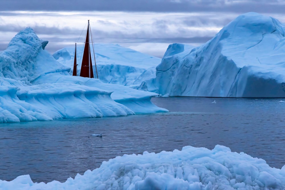
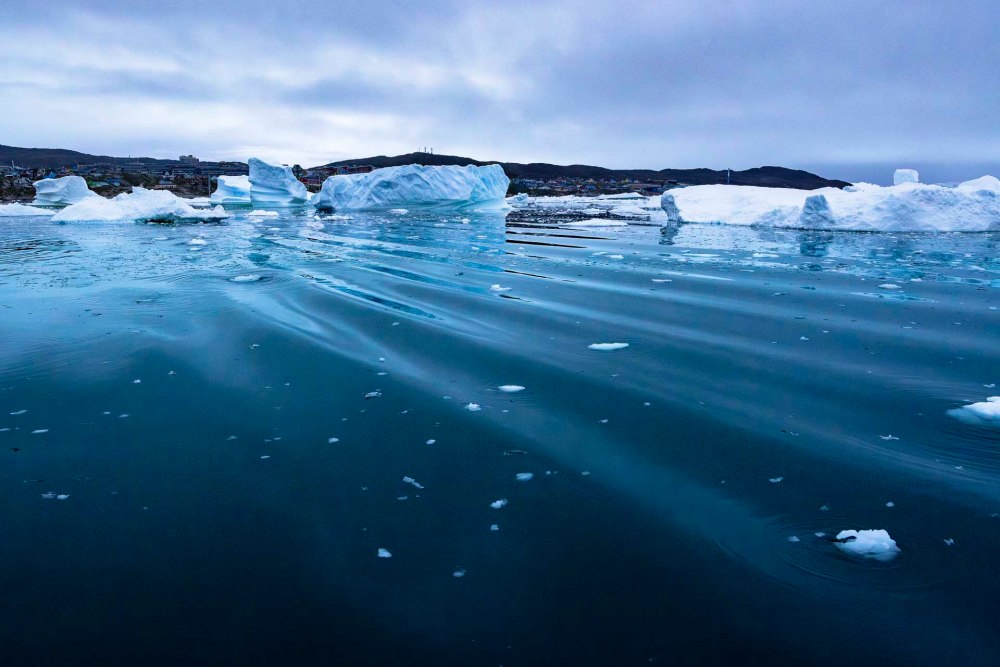
この日は光と霧が交錯する日でした。 It was a day of mixed light and fog.
そんな日だったからでしょうか。霧虹が見えました。 Was it because it was such a day? we saw the fogbow?
時間の経過と共に光の変化を感じることができました。 I could feel the light changing over time.
静かに海の上を滑りながら進む船の上で、心が満たされて行きました。 My heart was filled with contentment as the boat glided silently along on the sea.
雄大な自然の中に身を置くことが出来たことに、感謝の気持ちが湧いてきました。 I was so grateful to be able to put myself in the midst of such majestic nature.
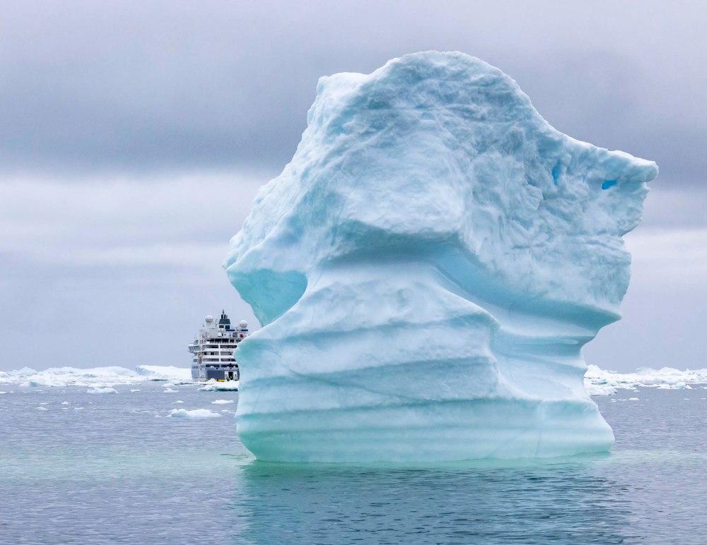
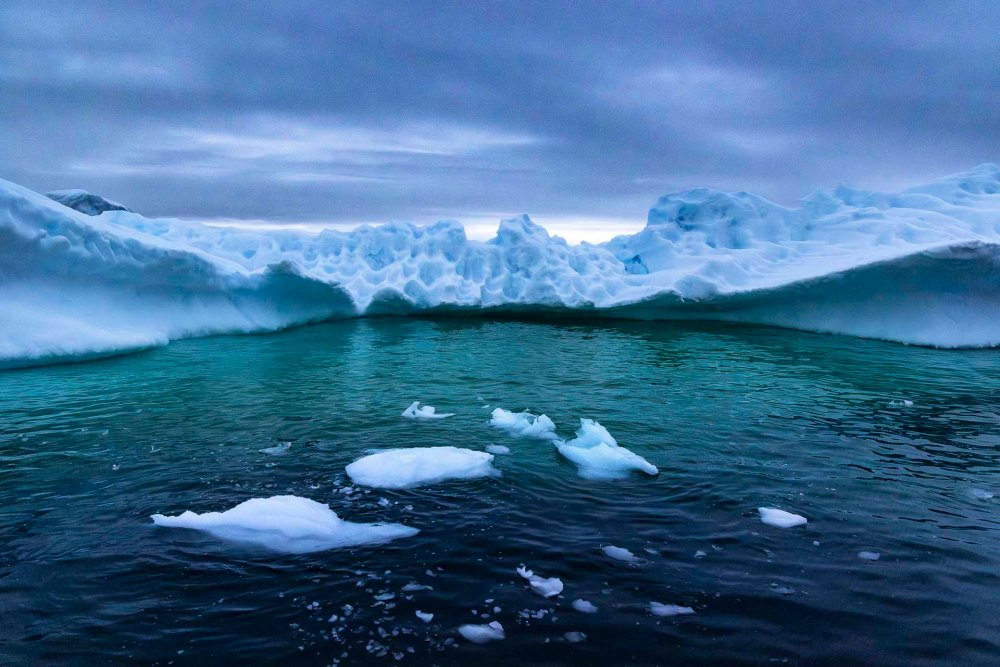
この氷山を見ることは2度とありません。勿論、全てのものは変化しているのですが、常に水の上を流れている氷山の変化の速度は目にみえる速さです。 This iceberg will never be seen again. Of course, everything is changing, but the speed of change of an iceberg that is constantly flowing on top of the water is very fast to the eye.
時折聞こえる爆発音は、実は氷山の一角が亀裂して砕け落ちる音でした。 The occasional sound of explosions was actually the cracking and shattering of a section of the iceberg.
こうして自分で撮った写真を振り返っていると、船の上にいた時に心の中に聞こえていた歌が再び蘇ってきました。 Looking back at my own photos in this way, the song I had heard in my heart when I was on the boat came back to me again.
閉じていく思い出の中のその中にいつも、忘れたくないささやきを聞く。 I always hear whispers that I don’t want to forget within those memories that are closing in.
こなごなに砕かれた鏡の上にも、新しい景色が映し出される。 Upon the shattered mirror, a new view is also reflected.
始まりの朝の静かな窓、ゼロになるからだ満たされてゆけ。 It’s a quiet window in the morning of the beginning, zeroing in, so fill it up, and reborn my dream.
輝くものはいつもここに、私の中に見つけられたから。 The shining thing is always here because I can find it in me.
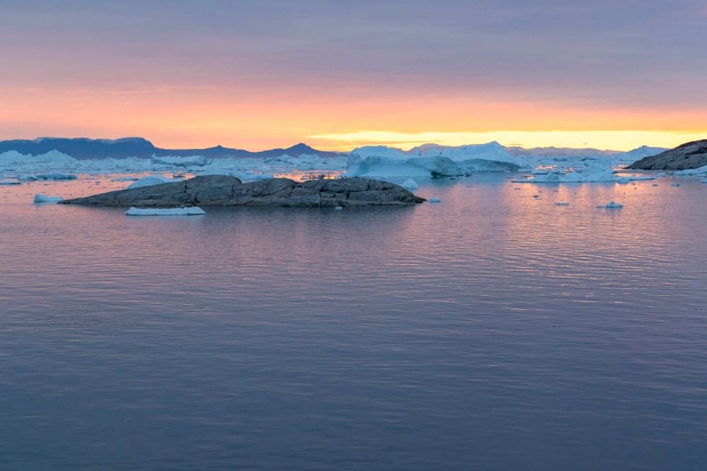
帰りの飛行機の中から見えたアイスフィヨルドを覆い尽くす氷山は、宝石を散りばめたように輝いていました。 The icebergs that covered the ice fjord seen from the plane on the way back were shining like scattered jewels.
イルリサット旅行記は今回で終了です。何度も目撃できクジラについては、後ほど書きます。 This is the end of the Ilulissat travelogue. Regarding the whales, which were spotted many times, I will write about them later.
Note: The translation of the lyrics, “Always with me” from “Spirited Away” movie, is my translation, not the official lyrics.
私たちの就寝時間はたいてい朝5時ごろなので、ホテルのビュッフェ朝食は見たことがありません。昼ごろ起きるので、昼食は私たちだけでは食べ、夕食はみんなと一緒に過ごしました。 Our bedtime was usually around 5:00 AM, so we never saw the buffet breakfast at the hotel. We’d wake up late and eat lunch on our own. Then we all spent the evening together for dinner.
この日は貝柱、そして、そこになんとも言えない魚ベースのスープが注がれました。美味!On this day, we had scallops, and an indescribable fish-based broth poured into it. Delicious!
そして、デザートは氷山のチーズケーキでした。笑 And dessert was iceberg cheesecake. LOL!
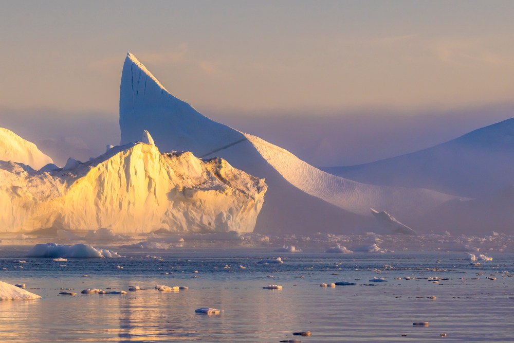
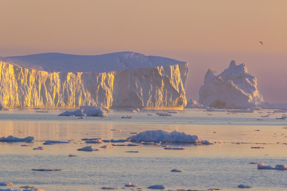
夜9時、再び光を求めて海に出かけて行きました。 At 9:00 p.m., we went out to sea again in search of light.
やっぱり写真は光と影。黄金色に広がる景色を楽しんでいました。 After all, photography is about light and shadow. I was enjoying the golden landscape.
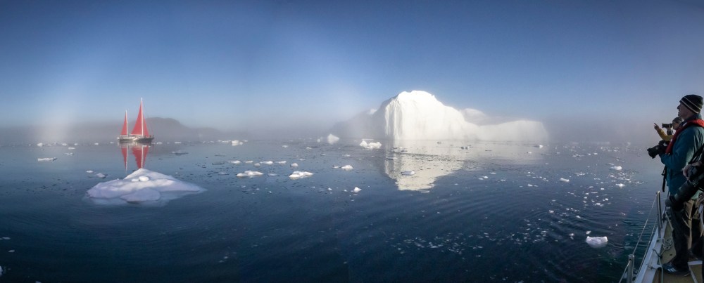
ふと気がつくと、真っ青な空をくっきりと分断して3分の1は雲に覆われていることに気がつきました。こちら、携帯のパノラマモードで撮りました。 Suddenly I noticed that the bright blue sky was clearly broken up and a third of it was covered with clouds. I took this photo in panorama mode of my cell phone.
日が沈み、あたりは黄金色からピンク色に変わっていきました。 As the sun set, the area turned from golden to pink.
ビーナスベルトが見える時間になっていました。 It was time to see the Belt of Venus.
そこで、私たちはもう1隻の船と連絡し合いながら船を雲の下に入れたり出したりと、ベストアングルを探しました。 So we communicated with the other boat to find the best angle, moving the boat in and out under the clouds.
ノロノロ動く船と刻一刻と変わっていく光との競争です。 It was a race between the slow-moving ship and the ever-changing light.
私たちはシャッターを押し続けました。 We continued to press the shutter.
ピンクのブランケットを被っているような景色に、いつまでも時間が止まってくれたら良いのにと思っていました。 Looking at the view as if it were covered with a pink blanket, I wished time would stand still forever.
もちろん、時は過ぎ去り、光も消えて行きました。 Of course, time passed and the light faded.
残念ながら、その後、霧が深く垂れこめてきてしまいました。3時間ほど粘りましたが、どんなに頑張っても良い写真は撮れませんでした。 Unfortunately, after the sun went down, a thick blanket of fog rolled in. For the next three hours, the fog hung so deep that no matter how hard I tried, I could not take good pictures.
最終的に諦めて小型ボートに乗り換えて桟橋に向かった時は、桟橋が全く見えなくなっていました。 When we finally gave up and switched to a smaller boat and headed for the pier, we couldn’t see the pier at all.
ピンクのブランケットを携帯ですがビデオも撮りました。ちょっとタイミングを逃してしまいましたが、雰囲気でていると思います。 I took a video of the pink blanket with my cell phone. Although I missed the timing, I think it shows the mood.
ワークショップ3日目を迎えました。天気は快晴、気分も爽快です。 The third day of the workshop had arrived. The weather was clear and the mood was invigorating, too.
夕食時、コーヒーソムリエがいたのでグリーンランドコーヒーを入れてもらいました。 At dinner, there was a coffee sommelier and I asked him to make me a cup of Greenland coffee.
しっかりと手順をビデオに収めたかったので、携帯カメラをビデオモードにして録画し始めたはずでした。でも、はしゃぎすぎてスタートボタンを押し忘れていました。 I wanted to video the procedure well, so I should have put my cell phone camera in video mode and started recording. But I was so excited that I forgot to press the start button.
半分以上経過した頃、隣にいたインストラクターに指摘されて慌ててスタートさせました。以下のビデオには私の失策にみんなの大笑いが入っていますが、雰囲気は伝わると思います。 After more than half the process, the instructor next to me pointed out that I didn’t push the record button. The following video contains everyone laughing hysterically at my blunder, but I think it conveys the atmosphere.
私たちの船は桟橋に近づけないので、まず桟橋から小型ボートに乗って、そこから乗り換えます。この作業は最初は怖かったものの、帰る頃にはみんな慣れていました。 Our boat was not allowed to go near the pier, so we would first take a small boat from the pier and then change from there. This process was scary at first, but by the time we left, everyone was used to it.
太陽の光があると言うことは、こんなに気持ちがいい。 It felt so good to have sunshine.
ところが、それも束の間、深い霧が押し寄せてきました。 However, this was short-lived, as a deep fog began to roll in.
そして、私たちは深い霧の中を彷徨っていました。 And we were wandering around in a thick fog.
それでもなんとか撮れた写真がこちらです。 Nevertheless, here are the photos I managed to take.
この日は霧だけじゃなく、赤い観光客船にも長いこと追いかけられ、気持ちが良かったはずの3日目の生気が萎えて行きました。 On this day, we were chased for a long time not only by fog but also by a red tourist boat, and the liveliness of the third day, which should have been pleasant, began to fade.
深い霧の中では何も撮れませんからね。 It’s hard to photograph anything in deep fog.
そこで、インストラクターが歌い出し、つられて私たちも歌い出し、挙げ句の果てに踊り出しました。こう言う時は、こんな憂さ晴らしが最高です。 The instructor started singing, we started singing, and finally we started dancing.This is the best way to relieve the sorrow at times like this.
写真の収穫はありませんでしたが、船上パーティーは楽しい思い出となりました。 Even though there was no photographic harvest, the party on board was a pleasant memory.
注記:「Oqaatsut」の地名の発音がよくわからないので、記憶にある発音をカタカナ書きにしました。 Note: I am not sure how to pronounce the name “Oqaatsut”, so I have transcribed the pronunciation in Katakana for Japanese based on my memory of the word.
ワークショップ2日目も雨でしたが、元気よく出発しました。 The second day of the workshop was also rainy, but we left in good spirits.
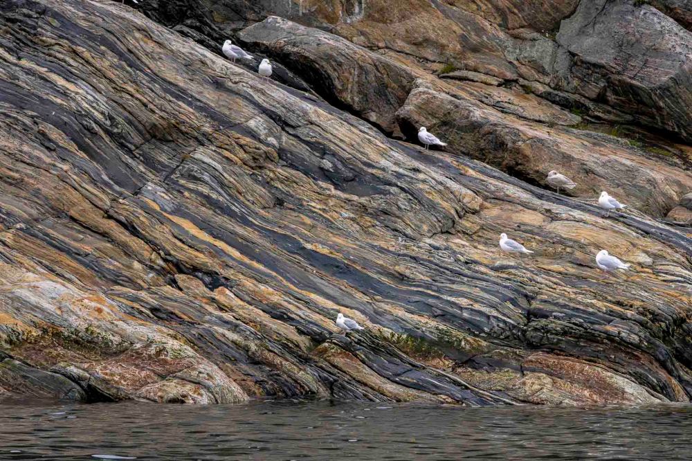
イルリサットの港を出る時に海岸を見ると、美しい地層の線が模様のように流れていました。 When I looked at the coast as we left the port of Ilulissat, I saw beautiful stratigraphic lines flowing like a pattern.
帰ってきてから調べると、この地帯は古原生代のものであることがわかりました。 Upon returning home, I examined the area and found that the zone was Palaeoproterozoic.
古原生代は地球史を半分ぐらい遡った頃をさします。最初の真核生物が生まれたころで、まだ1日が20時間しかなかった頃です。 The Palaeoproterozoic Era is about halfway back in Earth’s history. It was around the time when the first eukaryotes were born and the day was still only 20 hours long.
こんなに想像もつかないことを調査研究されている方々に感謝します。 A big thanks to those who are researching and studying such unimaginable things.
この日はカモメたちが大活躍した日でした。 わたしたちの船を誘導してクジラがいるところに連れて行ってくれたからです。 It was a day of great activity for the seagulls, as they guided our boat to the whales. They guided our boat to where the whales were.
この日私が撮ったクジラの写真の数は500枚ぐらいです。量が多すぎるので、クジラについては後ほど書きます。 The number of photos of whales I took that day is about 500. I will write more about whales later because it would be too much to include here.
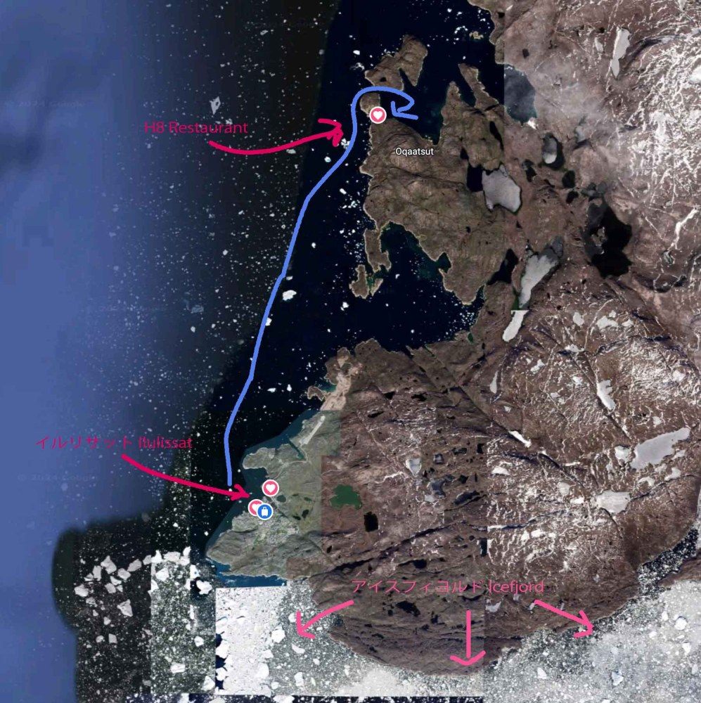
今日はイルリサットからそれほど遠くないですが、私たちのような船だと1時間以上北上したところにあるオカツァットという集落について書きます。 Today I write about the settlement of Oqaatsut, which is not far from Ilulissat, but more than an hour north in a boat like ours.
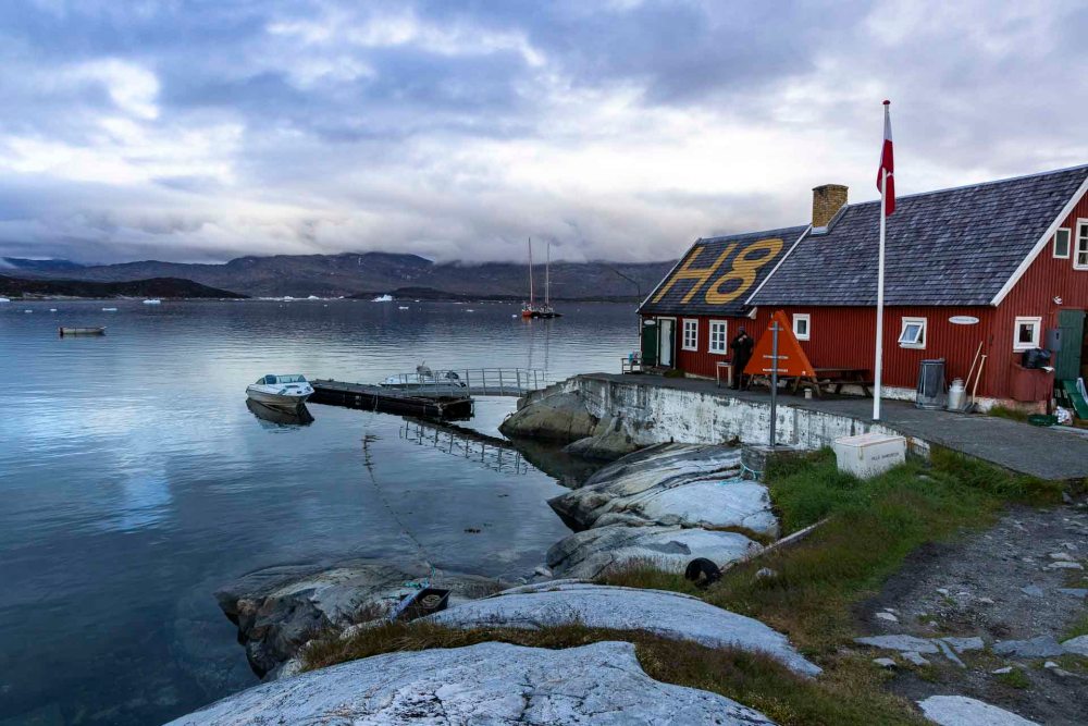
上陸した後すぐにH8というレストランで夕食をとりました。期間限定でオープンしているレストランで、星を5つあげてもいいほど美味しかったです。 Immediately after landing we had dinner at a restaurant called H8. The restaurant is open for a limited time only and was so good that I could have given it 5 stars.
この「H8」という名前は第二次世界大戦まで遡ります。迷子にならないようにアメリカ空軍はグリーンランドのそれぞれの町の家の屋根に「H1」から始まって順番につけて行ったということです。そしてここオカツァットには「H8」がつけられたと言うことです。The name, H8, dates back to World War 2 where the Americans numbered all cities on one roof top, so they could navigate from the sky. In Oqaatsut, it was the building, that today houses our restaurant, that were marked with the letter and number “H8”.
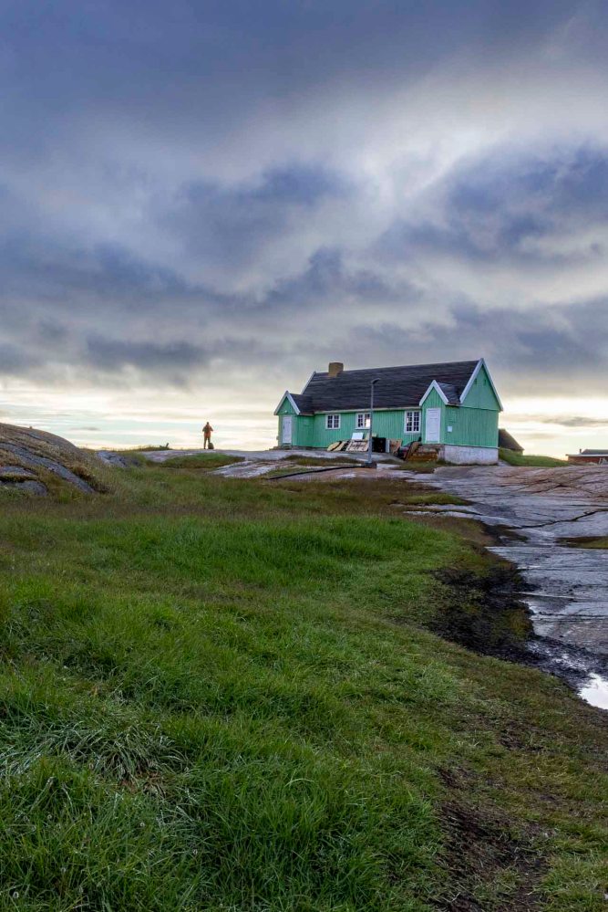
夕食の後、それぞれこの小さな場所の探索をしました。ワークショップ参加者の半数以上の人たちがドローンを持ってきていたので、ここで練習していました。 After dinner, we each explored this little place. Since more than half of the workshop participants had brought their drones with them, they practiced operating them here.
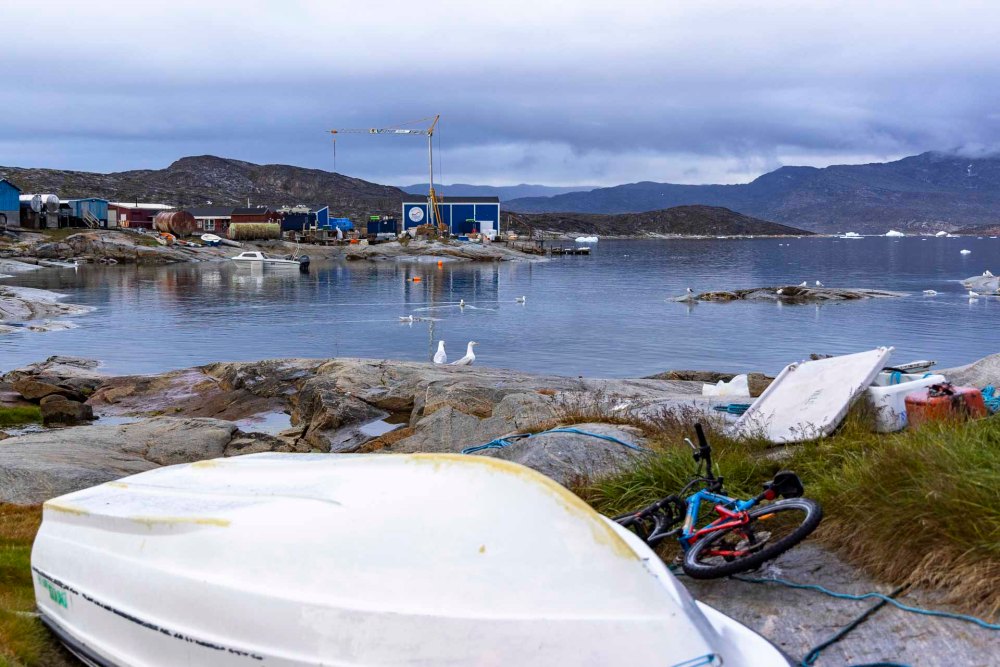
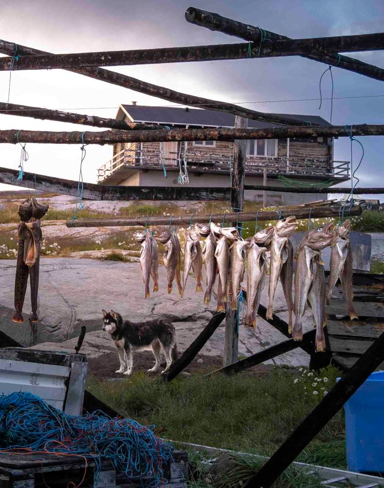
この集落には小さな魚工場があるだけで、ここの人たちのほとんどがそこで働いています。下の写真を見ていただくとわかりますが、中央の大きな建物が魚工場です。 There is only a small fish factory in this village, and most of the people here work there. As you can see in the photo below, the large building in the center is the fish factory.
手前にはボートと自転車が写っています。私の観察では、この自転車はここで使うものではなく、ボートで他の街に行った時に使うものだと思います。そう思う理由は、ここには道がなく、ツルツル滑る石の坂があるだけだからです。また、ここで使うのなら、家の近くに止めてあるはずです。この写真を撮ったのは夜中すぎ、村の人たちはきっと家で寝ていたはずです。 In the foreground you can see a boat and a bicycle. My observation is that this bicycle is not for use here, but for use when you go to other cities by boat. The reason I think so is because there are no roads here, only slippery stone slopes. Also, if it were used here, it would be parked near the house. It was after midnight when I took this picture, and the villagers must have been sleeping in their houses.
また、自転車の上には箱が見えます。この箱には魚を入れたりするのでしょう。なぜそう思うかというと、村人は彼らの冬の交通手段に餌をあげなければいけないからです。そう、犬ぞりです。 Also, you can see boxes above the bicycle. These boxes are probably used to store fish. The reason I think so is because the villagers have to feed their winter transportation. Yes, it is a dog sled.
私達が上陸した時は夜11時過ぎだったので村人は一人も見かけませんでした。でも、犬は15匹ぐらい見かけました。もう少し奥まで歩いて行ったらもっといたはずです。2020年のこの村の人口は29人なので、犬人口はもっと多いはずです。 When we landed, it was after 11:00 p.m. and we did not see a single villager. However, we did see about 15 dogs. The population of this village in 2020 is 29 people, so the dog population must be much higher.
この集落の最大で唯一の職種は漁業です。だから、こんな風景が見られます。 The largest and only occupation in this village is fishing. That is why you can see this kind of scenery.
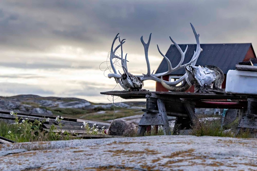
その他、おそらく時折現れる角を持った動物も大切な食糧になっているはずです。 Other animals with horns, which probably appear from time to time, are also important food sources.
歩きながら様々な思いが頭をよぎりました。夜中すぎ、あいにく、雨が降ってきたのでこの集落に別れを告げて再び海へ戻って行きました。 As I walked, my mind was filled with various thoughts. Unfortunately, after midnight, it began to rain, so we said goodbye to the village and headed back to the sea.
太陽が沈んでいくと、薄紅の中、遥か彼方にディスコ島が見えていました。 As the sun set, Disco Island was visible in the distance in a light red.
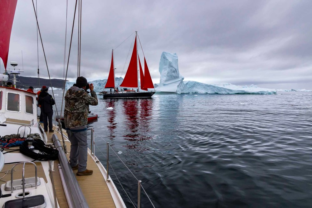
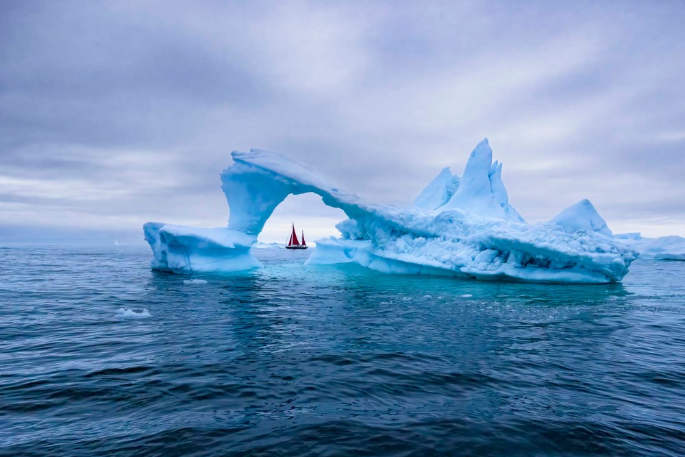
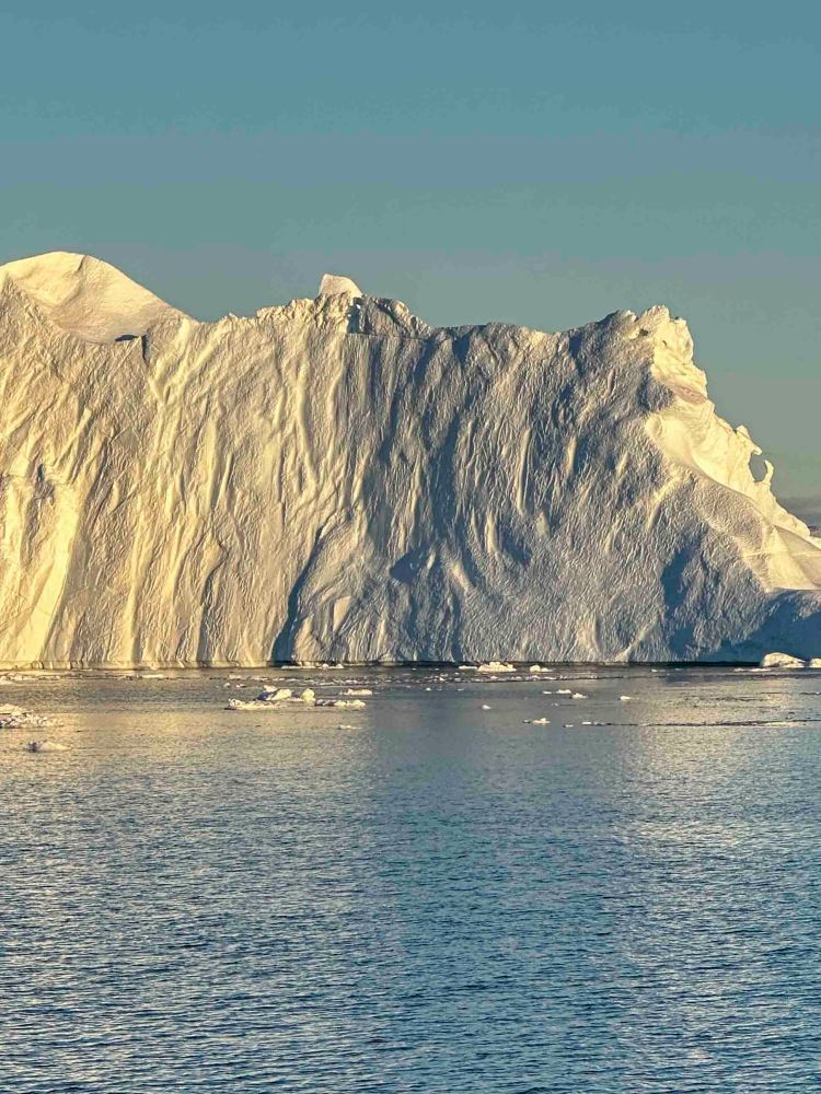
こんな氷山の合間を抜けて、クジラたちにも別れを告げてさらに進みました。 We said goodbye to the whales and continued on, passing between such icebergs.
わずかな光を求め、色々な角度から氷山を観察して、自己ベストのショットを模索しました。 Seeking the slightest light, I observed the iceberg from various angles to find my best shot.
この頃から私の中で「千と千尋の神隠し」と言う映画の中の歌「いつも何度でも」が繰り返し聞こえていました。 Since that time, I have repeatedly heard the song “Always with me” from the movie “Spirited Away” in my mind.
呼んでいる胸のどこか奥でいつも心踊る夢を見たい。 Deep inside my heart that is calling out to me, I want to dream a dream that always dances in my heart.
悲しみは数え切れないけれどその向こうできっとあなたに会える。 The sadness is uncountable, but I am sure I will see you on the other side of it.
繰り返す過ちのその度、人はただ青い空の青さを知る。 Whenever I repeat a mistake, I only know the blue of the blue sky.
果てしなく道は続いて見えるけれどこの両手は光を抱ける。 Although the road appears to be endless, I know these two hands can embrace the light.
(Note: The English translation is mine not the official lyrics.)
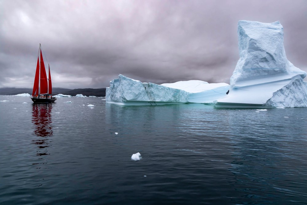
そして、何回も何回も氷山のアーチの向こうに船を配置して、ベストタイミングを待ちました。 And many, many, many times, we positioned the ship behind the arch of icebergs and waited for the best timing.
午前4時過ぎ、もうみんな疲れ切っていました。イルリサットの港が見えてきた時には懐かしさと安堵に満たされました。 It was past 4:00 a.m. and everyone was already exhausted. When the port of Ilulissat came into view, we were filled with nostalgia and relief.
ワークショップ初日のセイリングは雨の中をスタートして、帰る時まで雨でした。 Sailing on the first day of the workshop started in the rain and continued until returning in the early morning.
厚い雲が一晩中覆っていたので、いつ陽が落ちて、いつ登ってきたのか全くわかりませんでした。確か、日の入りから日の出までの時間は1時間ぐらいしかなかったと記憶しています。 Thick clouds covered the area all night, so I had no idea when the sun went down and when it came up. As I recall, there was only about an hour between sunset and sunrise.
カメラのISOの数値を1,000からスタートして、10,000まで引き上げました。 I started with my camera ISO value at 1,000 and raised it to 10,000.
クジラと名付けました。 I named it Whale.
さらに露出を下げてシャッタースピードを 1/200 以上に保つようにしました。 I further reduced the exposure and kept the shutter speed above 1/200.
ネズミと名付けました。 I named it Rat.
無理な状況下で無理やり写真を撮っていたので、ノイズのレベルが耐えられないほど高くなりました。泣く泣く切り捨てた写真は1,500枚以上です。例えば以下の写真。ノイズを頑張って消しましたが、空の色の回復はできませんでした。 The noise level became unbearably high as I was forced to take pictures under impossible lighting conditions. I have deleted more than 1,500 photos because of that. For example, I did my best to eliminate the noise from the following photo, but I could not recover the color of the sky.
また、こちらも同様で、ノイズを取りすぎてディテールが無くなってしまいました。 And the same is true here, too much noise was taken out and detail was lost.
それでも楽しかったです。鳥を追いかけ、氷山を探して無心にシャッターを切っていると時を忘れます。 Still, it was fun. Chasing birds, looking for icebergs, and mindlessly clicking the shutter, I lost track of time.
ホッカホカロンを背中に一つ、ジャケット3枚、パンツ3枚の重ね着でも寒かった。指が凍りつきそうでした。 It was cold even with a heating pad on my back, three jackets, and three layers of pants. My fingers were freezing.
みんな寒くて船室に入って行きました。もう本当に暗かった。青い色の世界でした。 Everyone went into the cabin because it was so cold. It was already really dark. It was a blue-colored world.
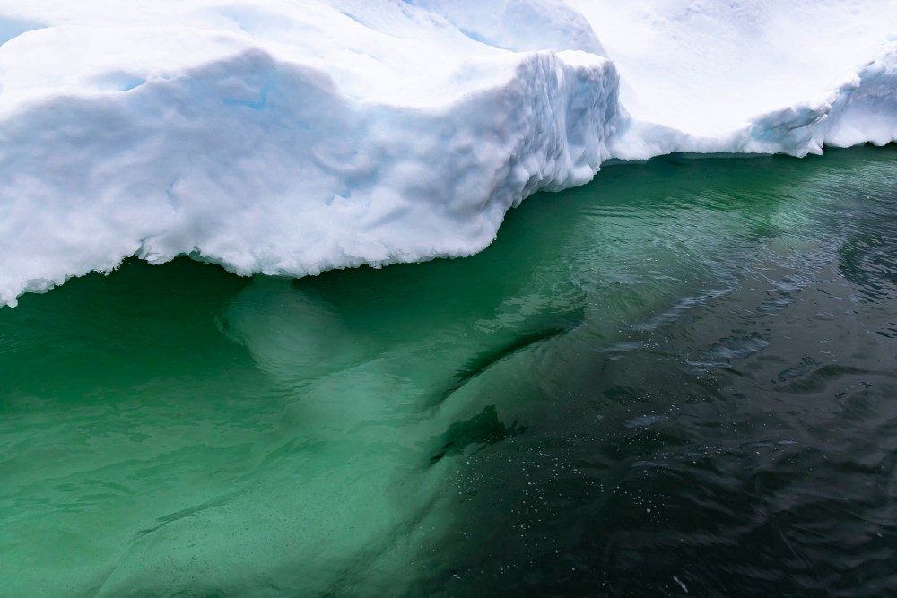
波と風の音、そして氷山の近くを通る時には、氷山が溶けて流れ落ちてくる音が聞こえていました。 We could hear the sound of the waves and the wind, and as we passed near the icebergs, we could hear them melting and trickling down.
たくさん氷山を見ていたら、陸上の山と同じなんだなと思いました。 Seeing so many icebergs made me think that they are just like mountains on land.
巨大な氷山も陸の岩壁も、いつかはエントロピーの流れに呑み込まれていく。 Both huge icebergs and land rock walls will one day be swallowed up by the flow of entropy.
さあ、いよいよ6日間のワークショップの始まりです。 Now it’s time for the six-day workshop to begin.
ホテルも移り、まずはオリエンテーションです。 We moved to a new hotel, and the first thing to do was orientation.
参加者は15人ぐらいだったと思います。船は2隻、プロのカメラマンが3人、そして船のクルーが6人か7人ぐらい。 I think there were about 15 participants. There were two boats, three professional photographers, and about six or seven boat crewmen.
そして、夕食も済ませて、夜9時にホテルのロビーに集合し、桟橋に向かいました。 Then, after dinner, we met in the hotel lobby at 9:00 p.m. and headed for the pier.
この日も雨。それでも10,000回以上シャッターを切りました。 It was raining on this day, too. Still, I took more than 10,000 shutter clicks.
今、写真を見直してますが、多すぎてどう処理していこうか悩んでます。 I’m reviewing the photos now, but there are too many and I’m wondering how to process them.
実のところ、ここ数日、目の強烈な痛さに耐えられず、眼科に駆け込みました。想像していた通りドライアイでしたが、ヤスリで擦られたように真っ赤に炎症していました。薬ももらい、一応落ち着いてきているので、一安心です。 As a matter of fact, I couldn’t stand the intense pain in my eyes for the past few days, so I rushed to the ophthalmologist. It was dry eye as I had imagined, but it was bright red and inflamed as if it had been rubbed with a file. I was given some medicine and it has calmed down, which is a relief.
ただ、あまり目を使わないようにと言われたので、写真のリビューはのんびりいきます。 However, I was told not to use my eyes too much, so I will take it easy on the photo review.
私たちの旅行の目的は写真のワークショップに参加するためでした。 The purpose of our trip was to attend a photography workshop.
ワークショップの前日、降り続いた雨が上がり快晴となりました。そこで私たちはワークショプ前に下見のつもりでアイスフィヨルドのボートツアーに参加しました。 The day before the workshop, the rain stopped and the weather cleared up. So we took a boat tour of the ice fjord as a preview before the workshop.
午後9時、夕食を済ませた後、ボートに乗り込みました。 At 9 p.m., after dinner, we boarded the boat.
スタート直後から感動で震えていました。 I was shaking with emotion right from the start.
ツアーガイドのフランクが氷河から流れてきた小さな氷のかけらを掬い上げてくれました。 Our tour guide, Frank, scooped up a small piece of ice that had drifted off the glacier.
表面は風雨の影響でツルンとしているわけではなく、ボコボコと凹んだ鱗のようでした。 The surface was not smooth from the wind and rain, but rather bumpy and pitted, looking a bit like scales on a fish.
3時間のツアーで400枚以上の写真を撮りました。 I took over 400 photos during the three-hour tour.
その中から頑張って絞り込み、選んだ写真が以下となります。 I did my best to narrow down the list and selected the following photos.
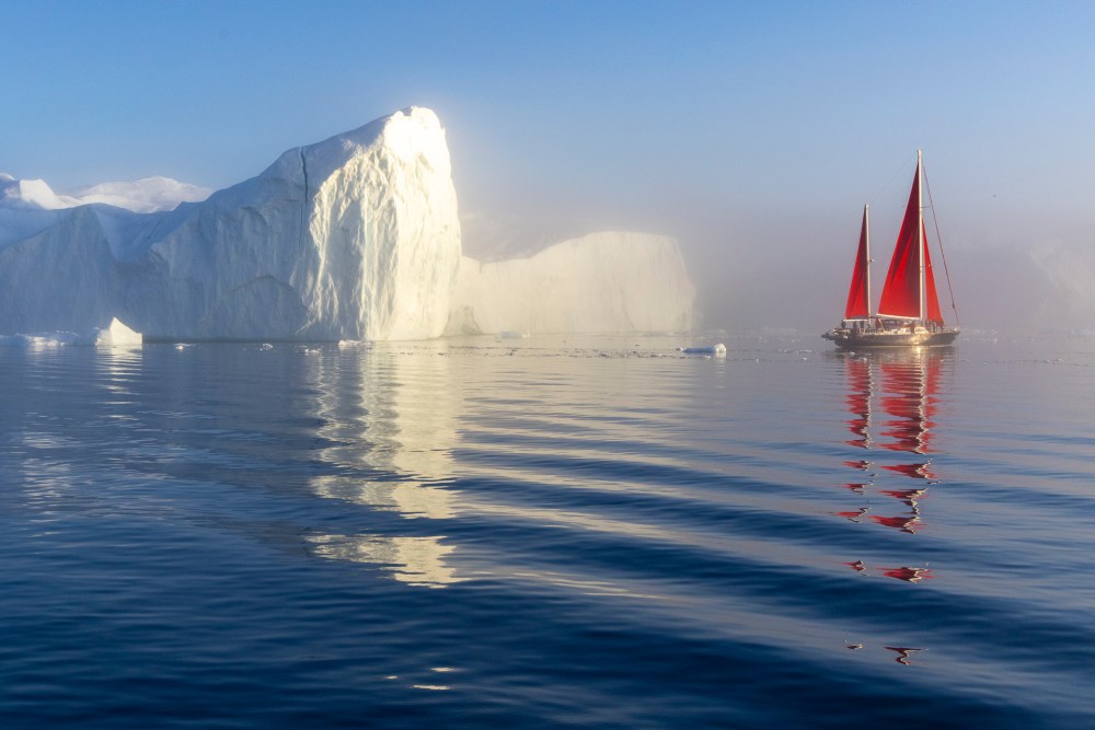
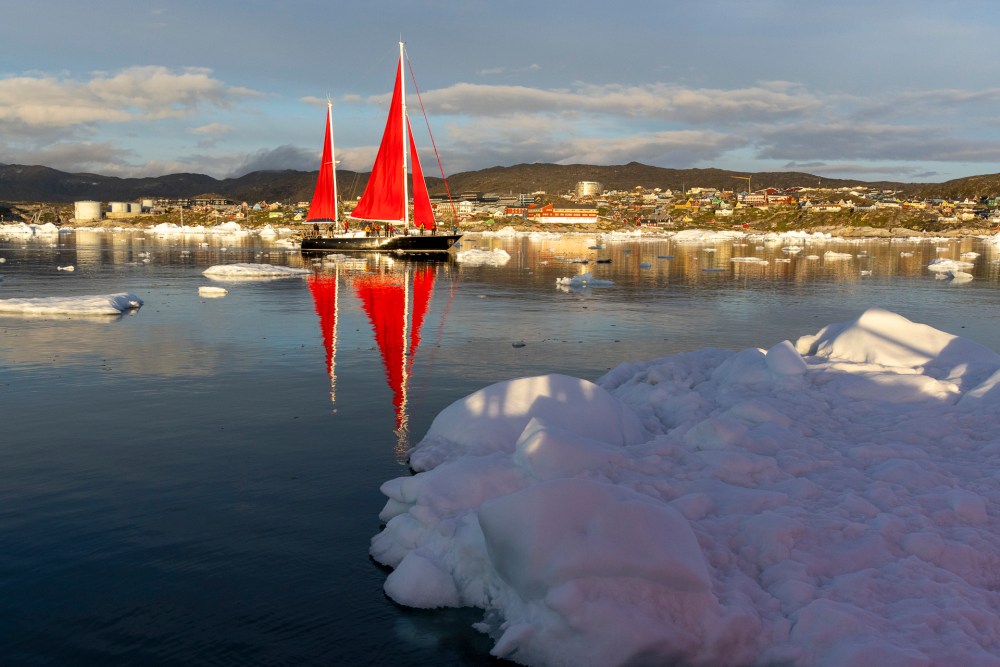
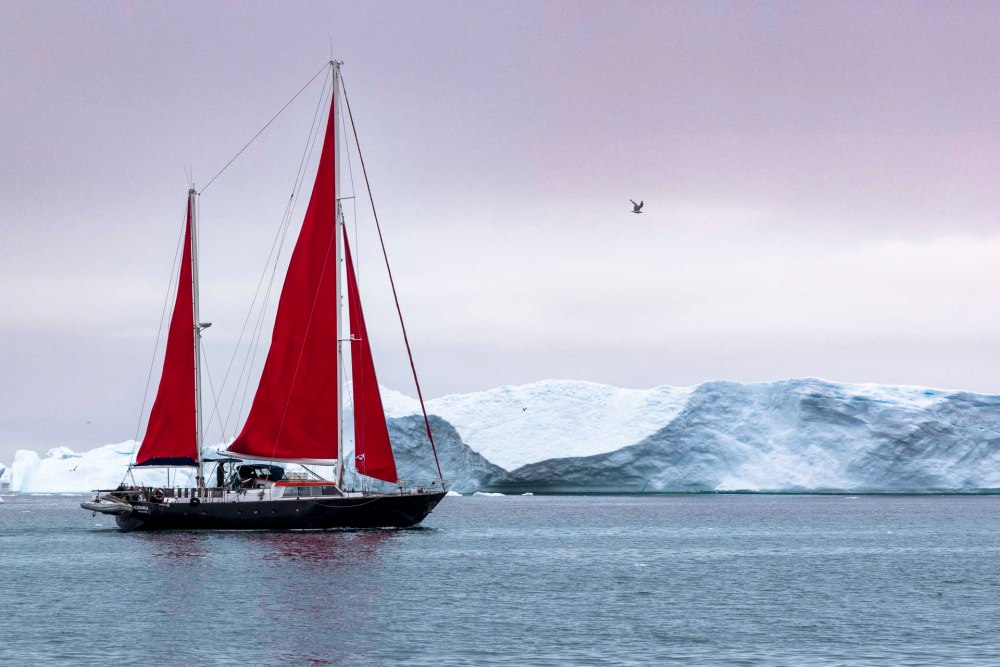
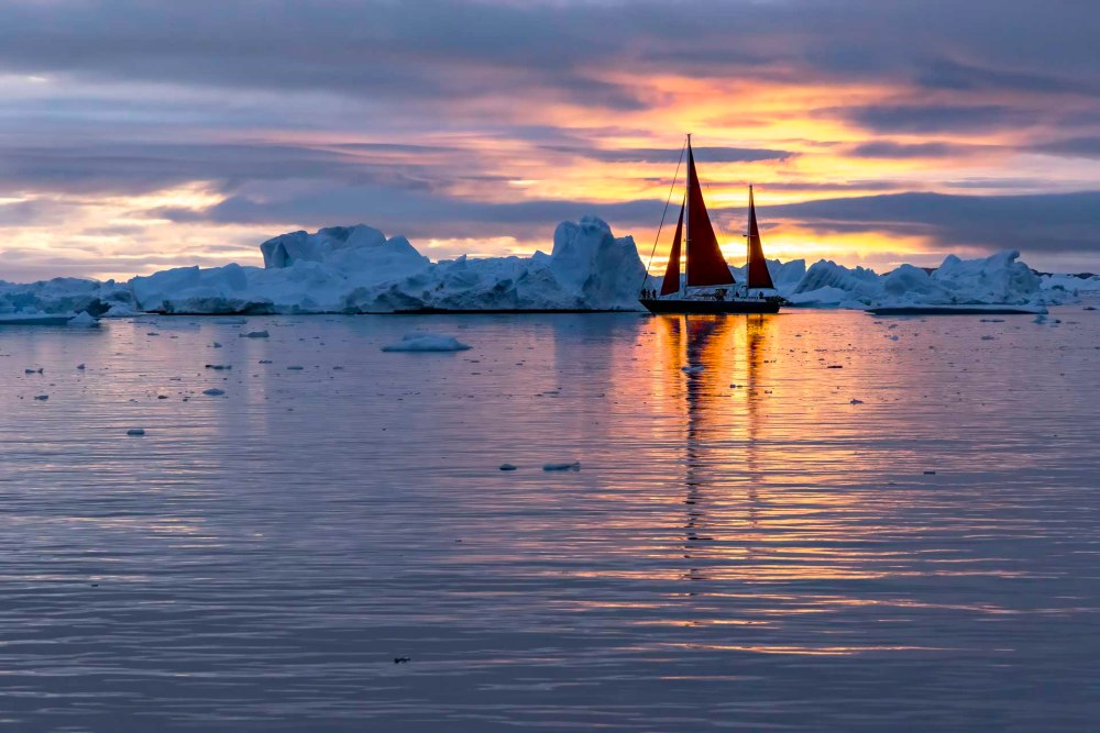
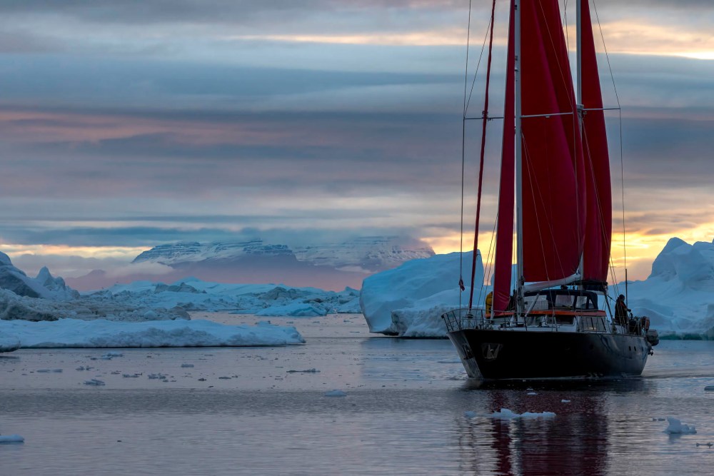
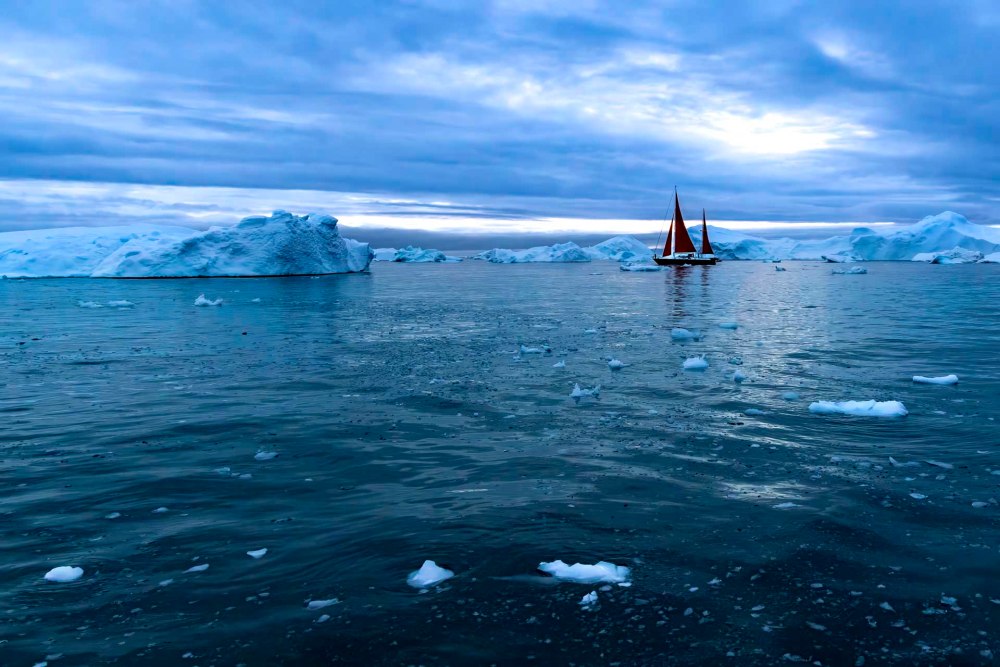
旅が終わりかけた頃、遠くに赤いセイルボートを発見しました。 Near the end of our trip, we spotted two red sailboats in the distance.
あれはまさに私たちが翌日から乗り込むボートです。 That was the very boat we were to board the next day.
高速で進むこのモーターボートとは違い、赤いセイルボートは私の10Kランの速さより少し早い程度で進みます。 Unlike this motorboat, which goes fast, the red sail boat goes only a little faster than my 10K run speed.
ホテルに戻ったのは12時過ぎ、部屋の窓からは水平線の上に沈みそうで沈まない太陽と、右端に幻日が見えていました。 It was past midnight when we returned to the hotel, and from the window of our room, I could see the sun that was about to set over the horizon and the sundog on the far right.
眼下をみると小さな氷山が宝石のように光っていました。 Looking down below, I saw small icebergs glistening like jewels.
最後に、ビデオも載せておきます。編集なしなので見にくいですが、、雰囲気はわかると思います。 Lastly, I’ve also included a video. It is unedited, so it is hard to watch, but you get the idea of the atmosphere.
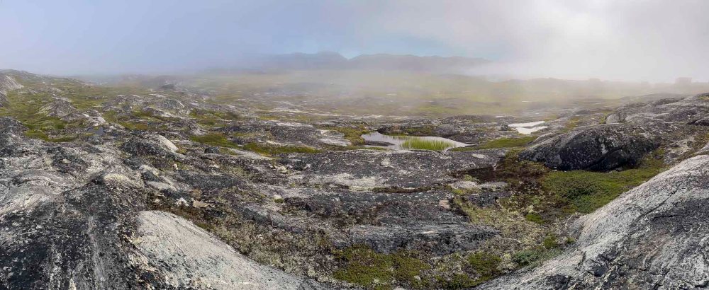
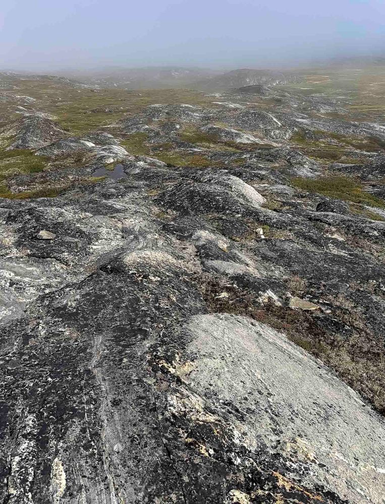
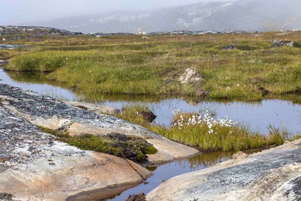
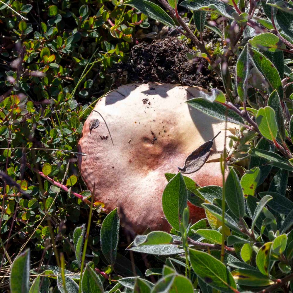
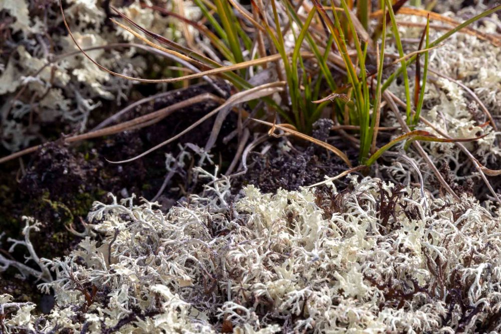
ツンドラ地帯は、地下に永久凍土が広がる草木が生えない地帯を指します。(高山ツンドラは少し違うようですね。) Tundra is the area where there is no grass or trees with permafrost beneath. (Alpine tundra is a little different.)
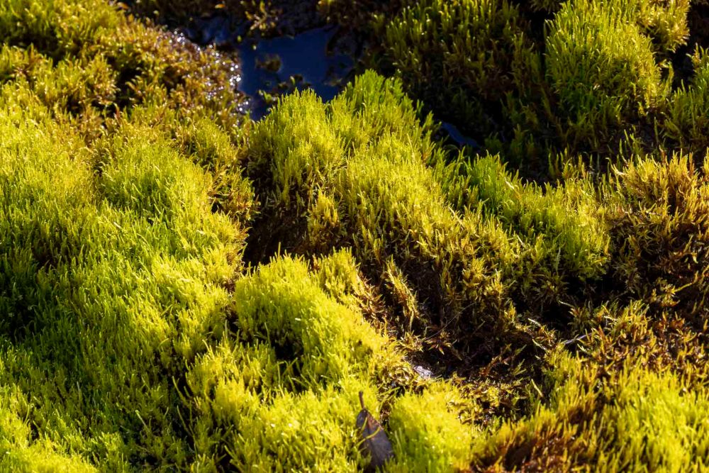
夏には地表の氷が溶けてコケや地衣類が生えてきます。 In summer, the ice on the ground surface melts and mosses and lichens grow.
氷河にもフィヨルドにも興味がありましたが、実は絶対に時間を見つけてツンドラの荒野を歩いてみたいと思っていました。I was interested in both the glaciers and the fjords, but in fact I definitely wanted to find time to walk the tundra wilderness.
なぜなら、友人に勧めらて『極限大地』という地質学者が書いた本を読んだからです。初めは英語版を読んでいましたが、あまりにも難解な専門用語が出てきたので、日本語訳で読み終えていました。 This is because a friend recommended a book written by a geologist called “A Wilder Time“. At first, I read the English version of the book, but I found the terminology too difficult to understand, so I finished reading the Japanese translation version.
バンちゃんは興味がないので、私一人でゆっくりと歩きました。 Banchan was not interested, so I walked slowly on my own.
ここで確かめてみたいことがいくつかありました。 There were a few things I wanted to check here.
一つめ:極限大地の本の中で作者は次のように記述しています。 First: In the book ”A Wilder Time”, the author describes;
With each step I took, I felt like I was trespassing. It seemed as if I was violently attacking the earth, which had been undisturbed for thousands of years, and contaminating it with my feet of dirt. (Omitted.) As soon as my boots left the ground, the details would hide again and the moss would return to its original form. (Note: The English quote is not the real quote from the book. It’s my translation from the Japanese edition.)
作者はその発見に「彼の存在は午後に吹くそよ風と同様、撮るに足らない存在」だと思い至ります。 The author comes to the realization that “his existence is as insignificant as the breeze in the afternoon.”
道がない場所だったので、私も彼と同じようにフカフカした厚い絨毯のようなコケの上を歩いていました。振り返ってみると、本当に、私の足跡など、どこにもない!彼の経験は本当だった事に感動しました。 There was no path, so I was walking on the same thick, fluffy carpet of moss as he was. When I looked back, there really were no footprints of mine, or any other footprints, anywhere! I was impressed that his experience was real.
もう一つは、見渡す限り誰もいないツンドラ荒野で、大声を上げて叫んでみたかった。 The other thing I wanted to do was to scream out loud in the tundra wilderness, where there was no one as far as the eye could see.
作者は、そんな事をしても荒野に吸い込まれてしまうだけだと記述します。「大昔の音のない世界と同じように無言で語りかけてくる。すべてをありのまま受け入れるようにと誘いかけてくる。」 The author describes how such a thing would only suck you into the wilderness. He says, “Like the soundless world of long ago, it speaks to us silently. It invites us to accept everything as it is.”
フヤー!(Yahooの逆さま)
HoYaa! (Reverse Yahoo)
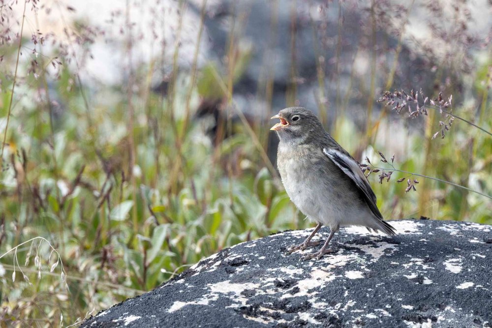
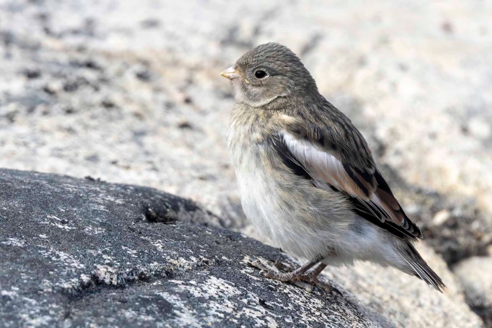
確かに、何の返信もなく、風の音だけが聞こえていました。私の近くでユキホオジロが行ったり来たりしていただけでした。 Indeed, there was no reply, only the sound of the wind. All I heard was a Snow Bunting coming and going near me.
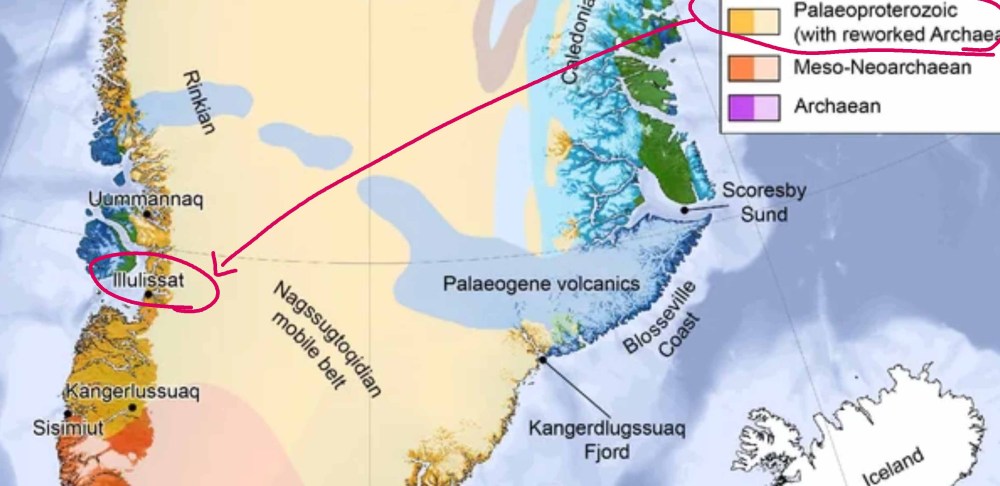
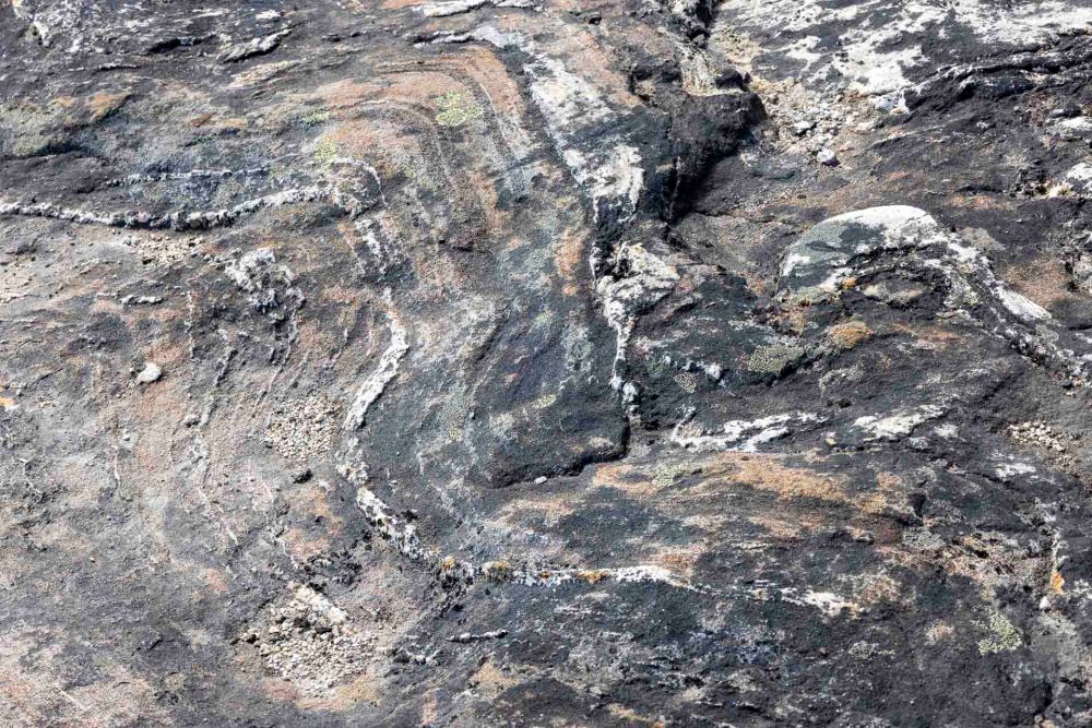
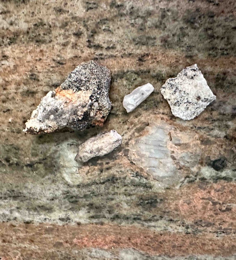
帰り道、作者が発見したように片麻岩を探しました。もちろん、深い知識がないので岩石を見てどんな石か区別ができるわけではありません。そこで、家のキッチンのカウンタートップと似たような模様なら、少なくとも花崗岩らしくなるので、そんな小さいかけらを拾ってホテルに戻りました。 On the way home, I looked for gneiss as the author discovered. Of course, not having in-depth knowledge, I could not distinguish what kind of stone it was by looking at the rock. So I picked up small pieces of gneiss that looked like granite, at least it had a similar pattern to the kitchen counter top at home.
補註:片麻岩は地下深くまで潜り込んで再結晶化した岩石です。二つの大陸がぶつかり、縫合された場所ではよく発見される岩石だそうです。後、作者達はそれを証明する証拠をさらに発見していきます。そして、まさにここは、18億年前、二つの大陸が衝突して縫合した場所 なんですね。すごい! Sidenote: Gneiss is a rock that has recrystallized after burrowing deep underground. It is a rock often found in places where two continents collide and are sutured together. Later, the author and fellow geologists discovered more evidence to prove it. And this was exactly where the two continents collided and stitched together 1.8 billion years ago. Amazing!
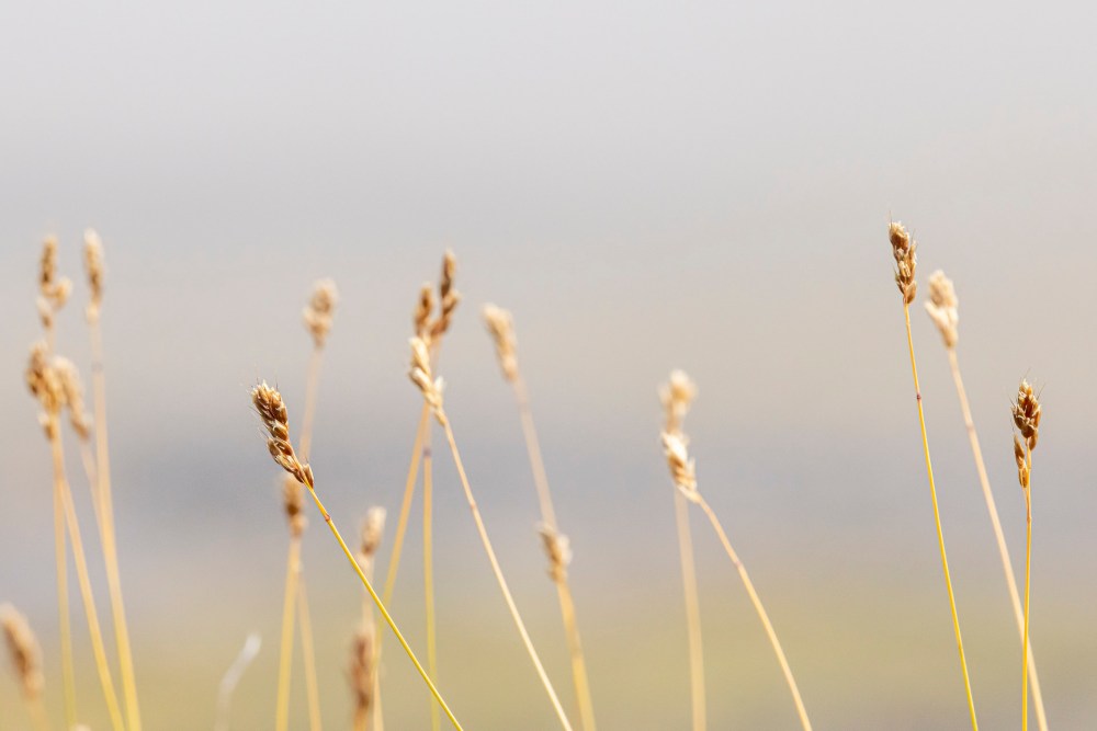
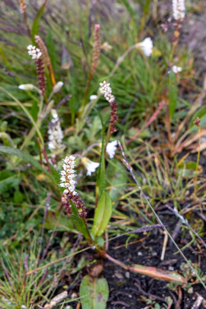
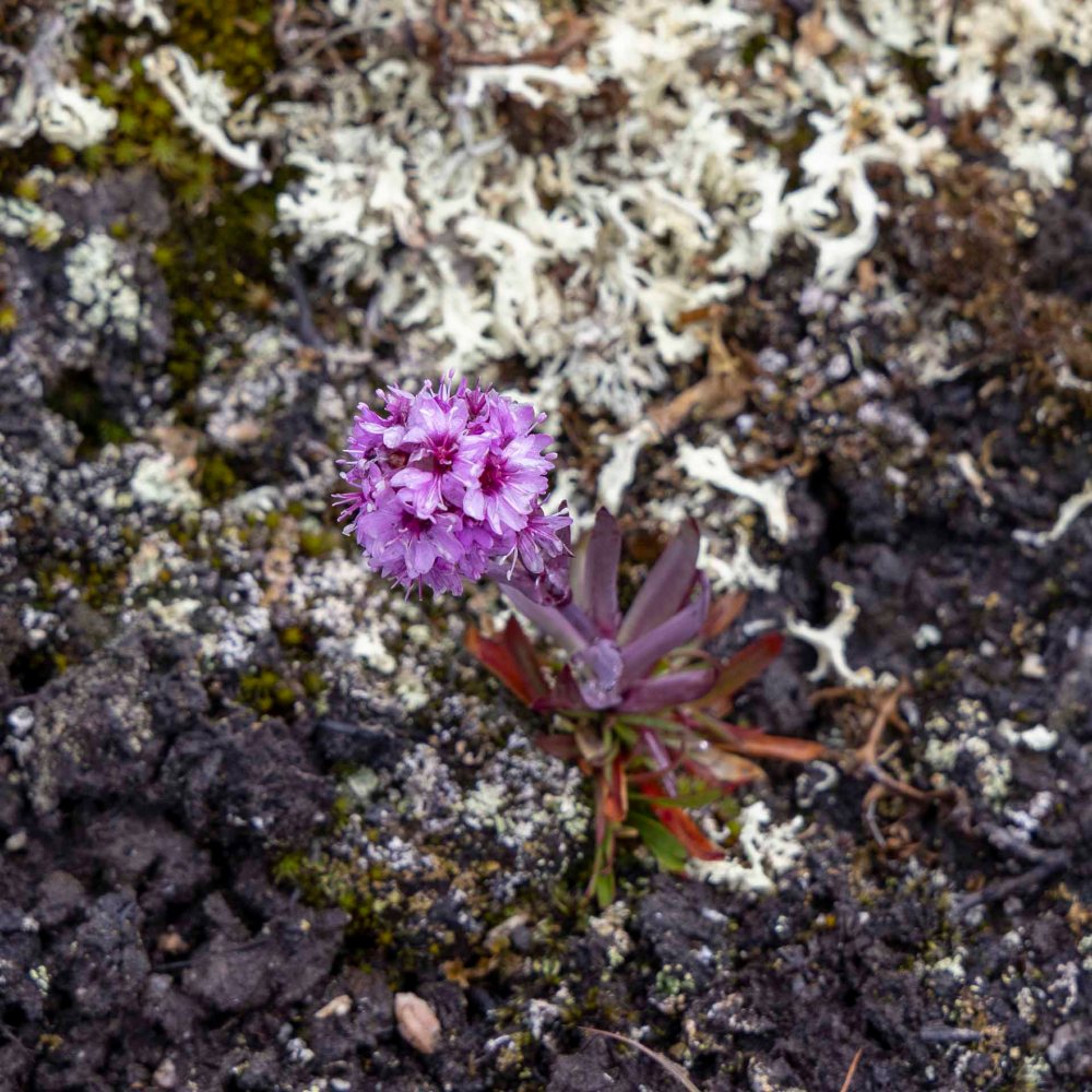
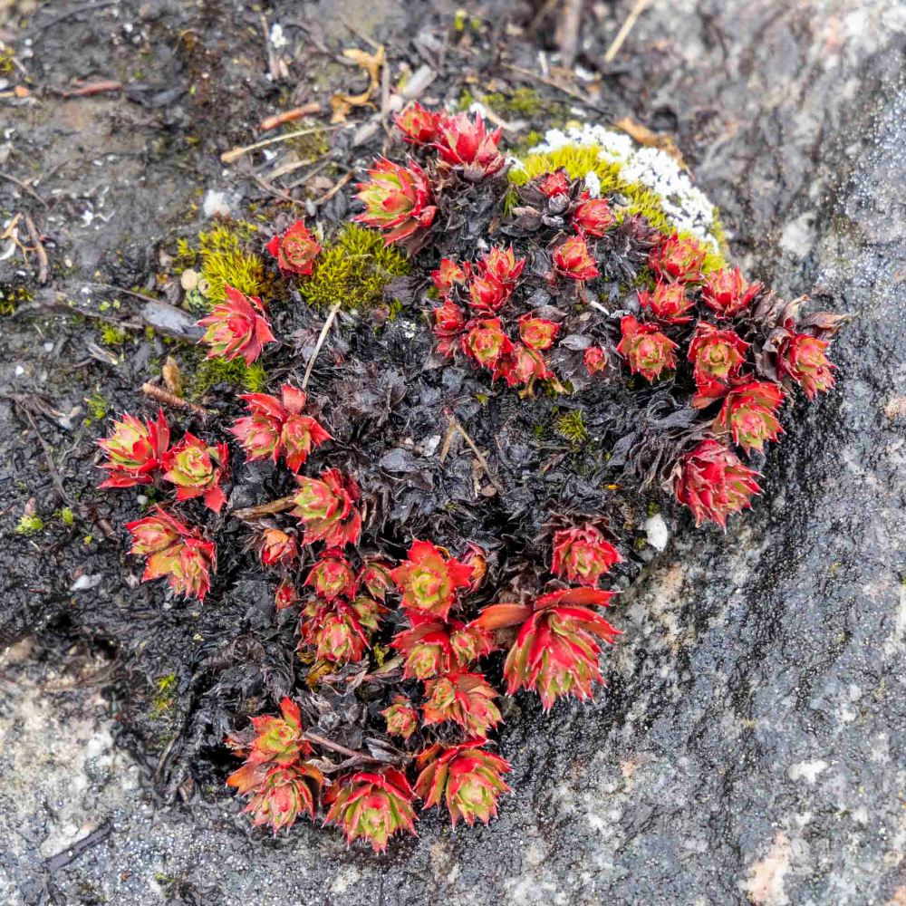
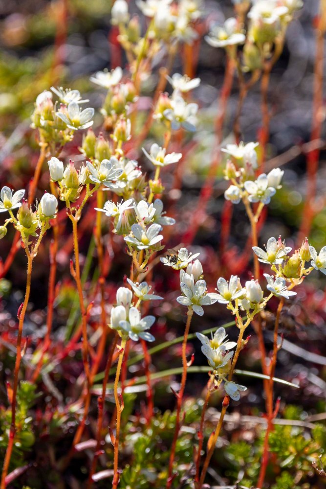
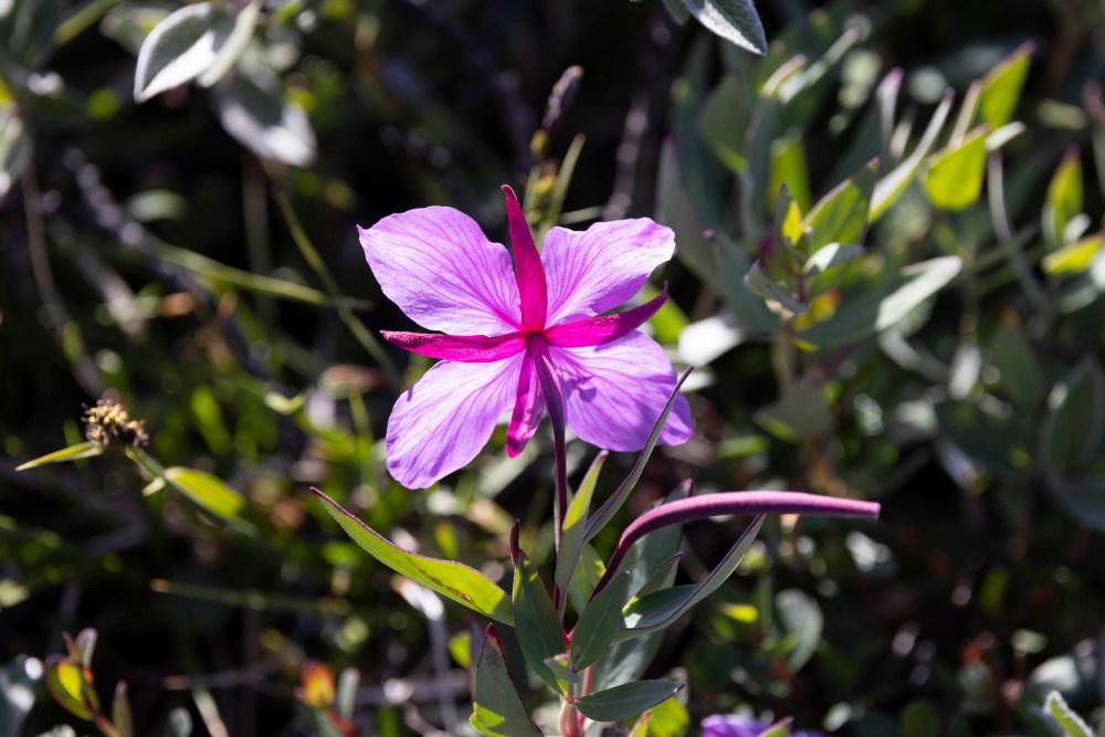
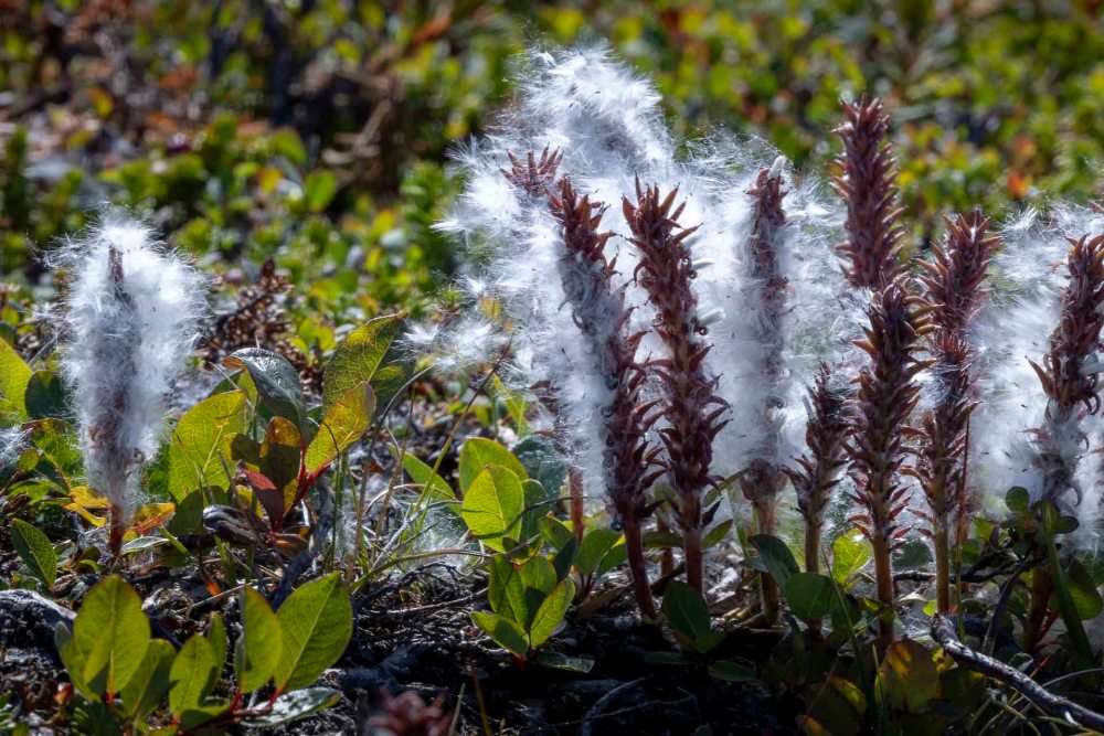
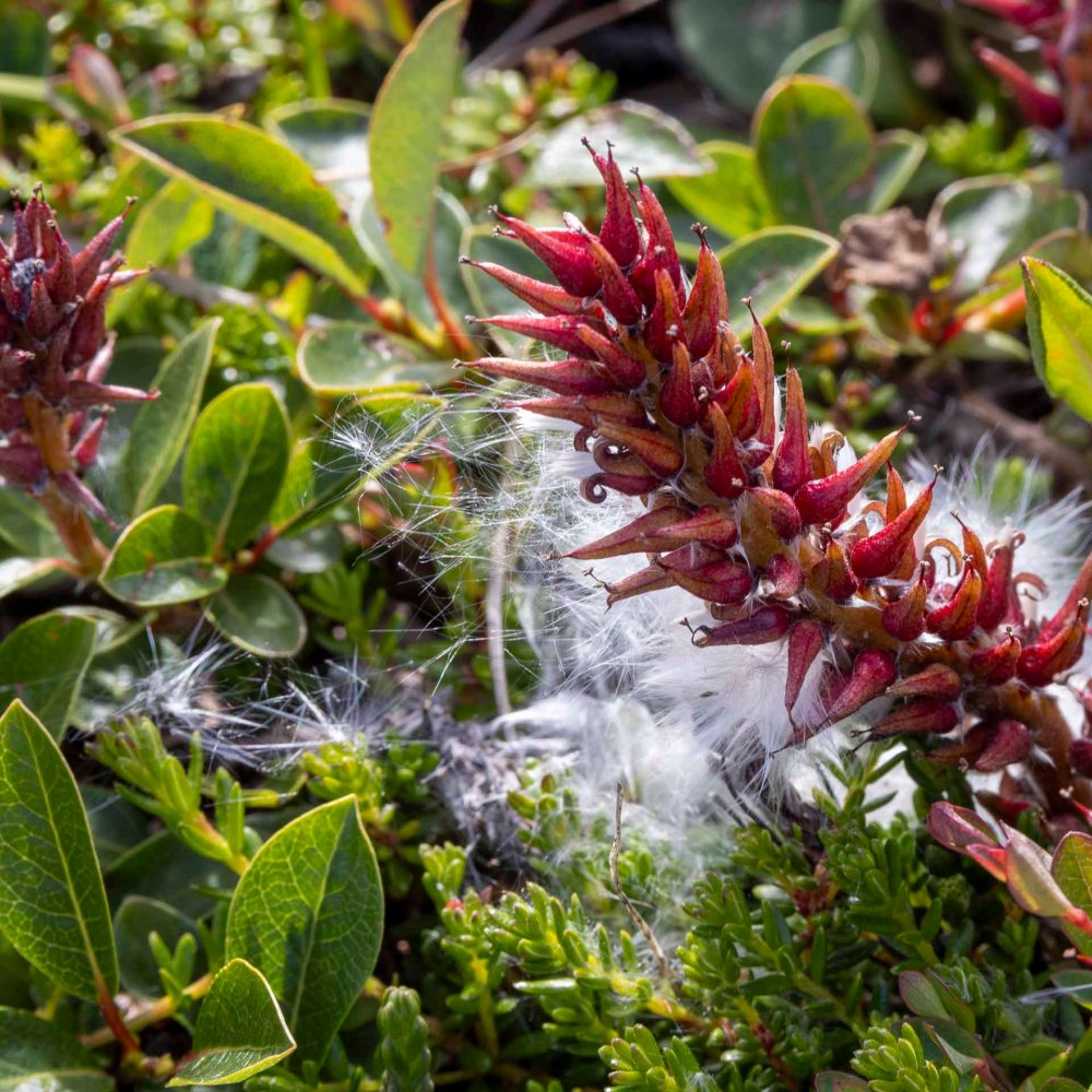
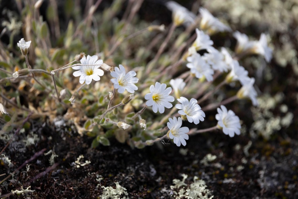
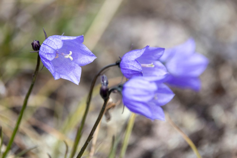
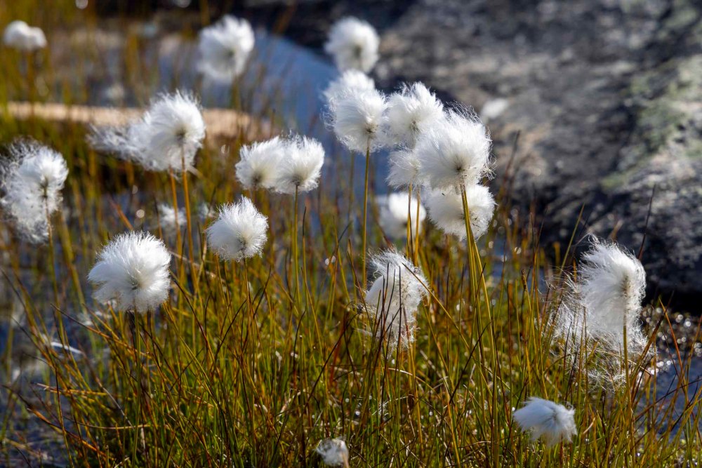
最後に、ツンドラで見かけた花や植物を紹介します。 Finally, here are some of the flowers and plants I saw on the tundra.
静まり返っていた夜中過ぎ、私たちはホテルに辿り着きました。The area was already quiet. We arrived at the hotel after midnight.
長い旅路の疲れもチェックインカウンターの後ろの豪華な景色が私たちを和ませてくれました。 The gorgeous view behind the hotel check-in counter soothed us from our long journey.
「ここからの眺めは最高ね!」 “The view from here is amazing!”
「ええ、でもちょうど昨日 白夜が終わって、少し暗くなりかけているのが不思議。これから少しずつ夜がやって来るのよ。」と、チェックインカウンターのお姉さんが教えてくれました。 “Yes, but it’s strange that the midnight sun ended just yesterday so it’s getting a little darker. The night is slowly coming on.” The lady at the check-in counter told us.
確か、その日の日の入りが午前1時59分、日の出は午前3時2分でした。1時間しか日が沈まない。日が沈んだとはいえ、暗くなるには程遠く、部屋のカーテンをぴっちり閉めて寝ました。 As I recall, sunset that day was at 1:59 a.m. and sunrise was at 3:02 a.m. The sun only set for an hour. Although the sun had set, it was far from dark, and we went to bed with the curtains of my room tightly closed.
着いた日も、翌日(正確には同じ日)も雨。 It rained the day we arrived and the next day (actually same day after we woke up later).
それでも私たちは1日中様々な事をして過ごしました。夕食後、部屋に帰ってくつろぎながら、外の景色にソワソワします。部屋の外は海。眼前に広がる景色の美しさを諦めて寝るには勿体無い。 Yet we spent the whole day doing all sorts of things. After dinner, we went back to our room to relax and soak in the view outside. Outside the room is the ocean. It would be a shame to give up on the beauty of the view before us and go to bed.
11:14pm
そこで同じような景色をパチパチ撮っていてある事にハッと気がつきました。もう白夜ではないけれど、、、 There I admired the light changing over time and took all the pictures I could. And then I suddenly noticed something. Although it is not a midnight sun anymore…
太陽が左から右へ、地平線に沿って動いていた!
The sun was moving along the horizon from left to right!
11:20pm12:17am12:28am1:11am1:37am 太陽が右の丘の後ろに沈んだ直後。Just after the sun sets behind the hill on the right.
この日の日の入りは 1:30am でした。The sunset was at 1:30am.
午前1時47分、あたりはビーナスベルトの幻想的な色に包まれてきました。この時点でこの日の午後のアクティビティに備えて寝ることにしました。 At 1:47 a.m., the area was becoming enveloped in the fantastic colors of the belt of Venus. At this point, I decided to go to bed in preparation for the activities in the afternoon for the next day.
参考:今年のイルリサットの白夜は5月20日から7月23日まででした。
Note: This year’s Ilulissat midnight sun was from May 20 to July 23.
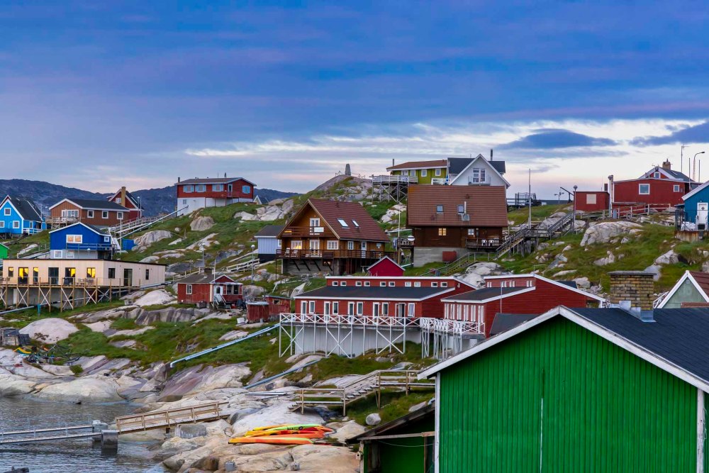
イルリサット旅行記、イントロとして、あくまでも私の印象でしかありませんが町の紹介を少しします。 As an introduction to the Ilulissat travelogue, I would like to introduce a little about the town, although it is only based on my impression.
自宅を出発してから2.5日後にイルリサットのホテルに辿り着きました。もしも直行便の飛行機があるのなら、多分10時間ぐらいで着くのではないかな。とりわけアイスランドからイルリサットまでの飛行機がキャンセルとなり、ホテルで足止めとなったこともあって、遠い南半球の国に行くような時間のかかる移動となりました。 We arrived at our hotel in Ilulissat 2.5 days after leaving home. If there was a direct flight, it would probably take only 10 hours to get there. Among other things, the flight from Iceland to Ilulissat was cancelled and we were stranded in a lobby at a hotel, which made the trip as time-consuming as if we were going to a distant southern hemisphere country.
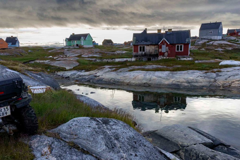
人口4000人ちょっとの小さな町です。町一周も1日あれば徒歩でできてしまいます。また、シャトルバスやタクシーもあるので、大きな荷物を持ちながらの移動も問題にはなりません。 It is a small town with a population of a little over 4,000. A around the town tour can be done on foot in a day. There are also shuttle buses and cabs, so getting around with large luggage is not a problem.
グリーンランドはデンマークの統治下で、デンマークから夏の間の仕事にきている人たちも多そうです。通貨もデンマークのクローネですが、キャッシュは全く必要ありません。全てクレジットカードで決済できます。唯一の例外は私たちの船のクルー達と写真家へのチップでした。それもアメリカドルで済ませました。(基本、チップは必要ありません。) Greenland is under Danish rule and many people seem to come from Denmark for summer work. The currency is also the Danish krone, but cash is not required at all. Everything can be done by credit card. The only exception was tipping our ship’s crew and photographer guide. We used American dollars for that as well. (Basically, you don’t need to tip).
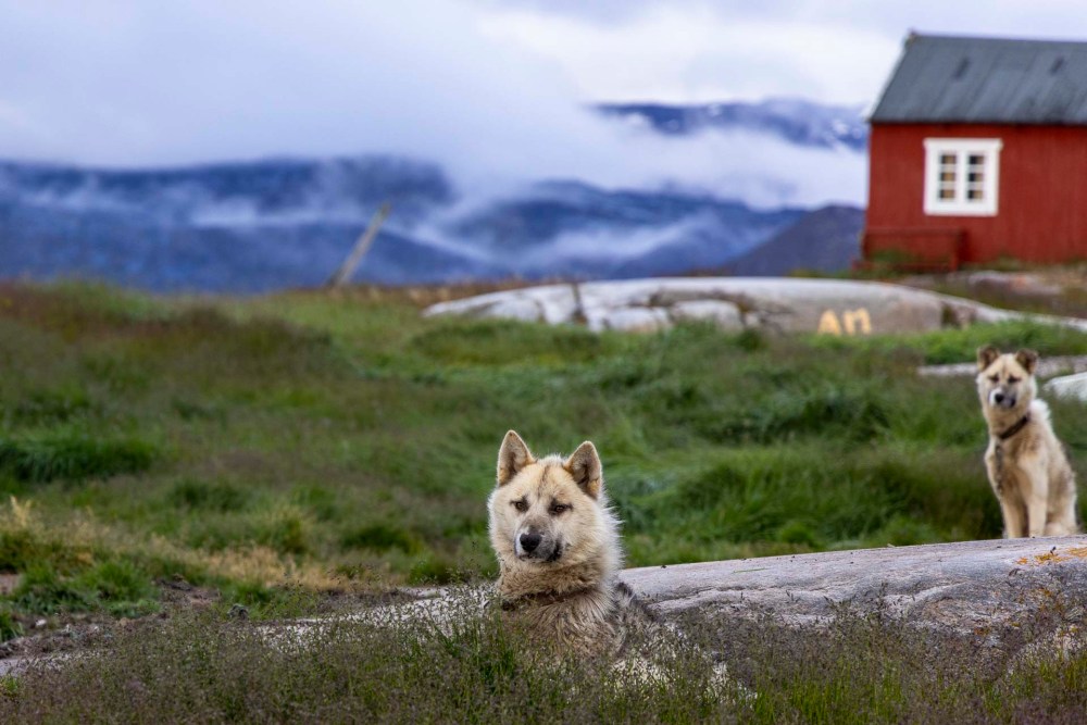
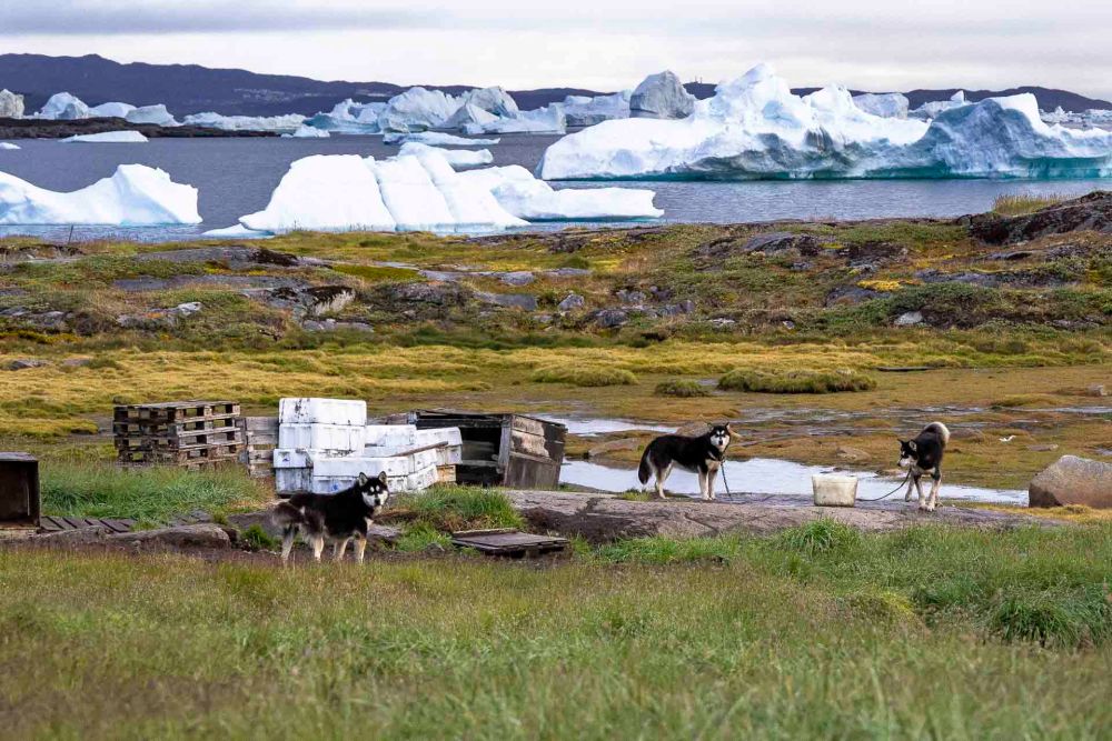
特記する事は、犬ぞりの犬の数は人口よりも多く、4500匹という事です。私たちの滞在中はまだ夏なので、犬たちは何もする事がなく毎日を過ごします。 It is worth mentioning that there are 4,500 sled dogs, which is more than the population. Since it is summer during our stay, the dogs spend their days with nothing to do.
アイスフィヨルドセンターへの道沿いに住む犬達。 Dogs living along the road to the Icefjord Center.
でも、この短い夏こそ大切な期間で、子犬たちが産まれ、厳しい冬が来る前に逞しく成長する時だからです。 But this short summer is an important time for them because it is when the puppies are born and grow strong before the harsh winter arrives.
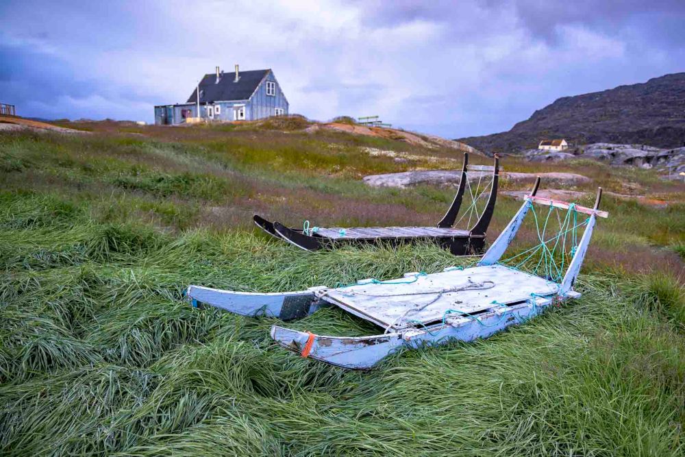
最近は冬の交通手段にスノーモービルが取り入れられるようになりました。でも、主流はまだ断然犬ぞりです。 Recently, snowmobiles have been introduced as a winter transportation. But the mainstream is still definitely dog sledding.
もう一点、2004年にこの地のアイスフィヨルドが世界遺産に登録されました。それにより、この町は一気に脚光を浴び始めました。 On another note, the ice fjord here was registered as a World Heritage site in 2004. This brought the town into the limelight.
観光客の量がグンと増え、豪華なホテルもでき、まださらに建設中の建物があちこちに見られます。また、新しく大きな飛行場の建設も計画されています。 The amount of tourists has increased dramatically, luxury hotels have been built, and there are still more buildings under construction here and there. There are also plans to build a new, large airfield.
イルリサットの飛行場。 Ilulissat Airport.
今はコペンハーゲンとアイスランドから1日一便、そしてグリーンランドの他の街からも飛んでいるようですが、頻度は分かりません。 Right now there is one flight a day from Copenhagen and Iceland, and apparently also from other cities in Greenland, but I don’t know how often.
ただ、今後観光客の量の増加と共に頻度は増加していく事は必須です。便利になっていく一方、今後の街の変化がどうなるのか心配でもあります。 However, it is imperative that the frequency will increase with the increase in the amount of tourists in the future. While it is becoming more convenient, I am also concerned about how the town will change in the future.
スーツケースが3個ぐらいしか乗らないターンテーブル。The turntable that only holds about three suitcases.
観光に関して言えば、ガイド付きのボートツアーがたくさんあります。現地についてからでも予約が可能です。また、ハイキングもおすすめです。距離と難易度で4種類のハイキングコースがあります。それぞれ魅力的で、どれが一番と言いにくいです。ツンドラ地帯の植物を観察しつつ、目の前に巨大な氷山を眺める。時を超えた景色に圧倒されます。 As far as sightseeing is concerned, there are many guided boat tours available. You can book them even after you arrive there. Hiking is also recommended. There are four different hiking trails, varying in distance and difficulty. Each is fascinating in its own way, and it is difficult to say which is the best. While observing the flora of the tundra area, you will see a huge iceberg in front of you. You will be overwhelmed by the timeless scenery.
以上が町の紹介でした。次回からは私の感動した事を少しずつ書きます。 That was my introduction to the town. I will write a little more about what impressed me in the next issue.
ディスコ湾沿いに建っているザイオン教会。Zion’s Church stands next to Disco Bay.
P.S. The missing suitcases were delivered to our city, Saint George’s Airport, apparently via super-express delivery after four different flights. We were thrilled with the sudden delivery, as we had already given up and contacted our travel insurance company.
グリーンランドの西側、北極圏内にあるイルリサットという町に行ってきました。 I visited the town of Ilulissat, located on the western side of Greenland, inside the Arctic Circle.
イルリサット滞在中の経験は、私の旅行歴の中でも、多分、トップ3に入るほど素晴らしいものでした。 My experience during my stay in Ilulissat was probably one of the top three most amazing experiences in my travel history.
その間に撮った写真は2万枚以上に上りました。これから写真をハードディスクにコピーしつつ、旅行記を少しずつ書いて聞きます。 The number of photos I took during that time amounted to more than 20,000. I will be writing a travelogue of the trip while copying the photos to my hard disk a little at a time.
ただ、私たちのスーツケースが行方不明となり、今だに所在が分からず落ち着きません。実のところ、行きのフライトも搭乗時間5分後にキャンセルになったり、帰りも同様な結果となりました。チェックインしたスーツケースはイルリサットからの飛行場から出ることはなく、そのまま行方不明になった可能性が大です。クレームも出していますが、音信不通です。今後 Iceland Air は一切使いません。それほど対応が悪かったです。ネガティブな事を書くことを一回だけ許してくださいね。 Upon returning from the trip, however, our suitcases have gone missing and we are still in the dark as to their whereabouts! As a matter of fact, our flight to the Ilulissat was cancelled 5 minutes after boarding time, and the same happened on the way back. It is very possible that our checked-in suitcases never left the airfield from Ilulissat and just went missing. We have filed a lost baggage report but have not heard from them yet. I will never use Iceland Air in the future. That’s how bad the service was. Please forgive me for once writing something negative.
さあ、フラストレーションのガス抜きができました。私たちの2度とない素晴らしい旅行の思い出を汚したくないので、今後、忘れることにして、さっさと先に進みます。 Now, the frustration has been vented. I don’t want to tarnish the memories of our once in a lifetime wonderful trip, so I will forget about it in the future and move on quickly.
鳥類の分類も水禽類まできました。この分類が終われば、最初から一番分類したかった次のグループ、陸の鳥類が待っています。 The long process of classifying birds has come to Aequomithes, the waterbirds. Once this clade classification is complete, the next clade that I wanted to classify the most, Teliurarves, Landbirds, awaits.
私の分類は、ただ単に私が撮りためた鳥の写真の整理のための区分です。水禽類は全部まとめて1つのグループにして5番目のグループとしました。 Rather than detailing all the different types of waterbirds, I have grouped all of the waterbirds together into one group, the fifth group from the top of the list.
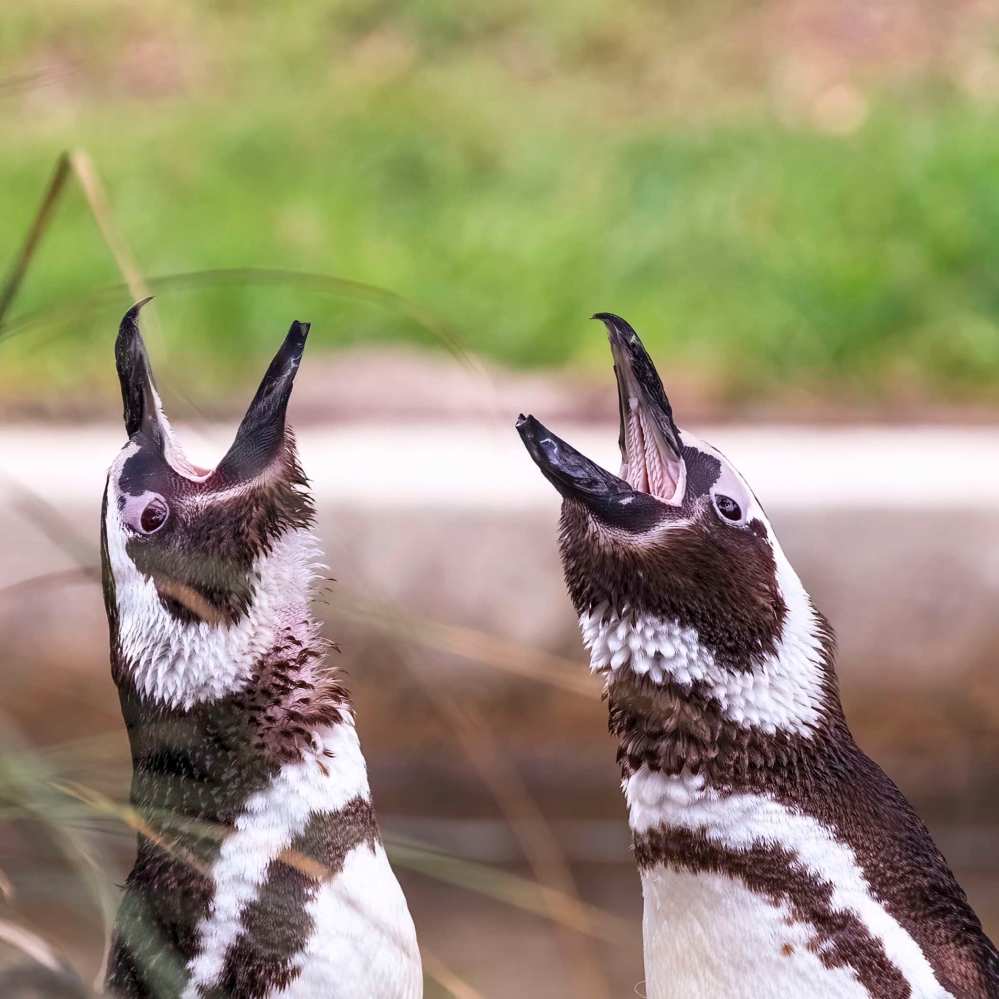
このグループで私が撮りたい鳥はペンギンです。どの種も南半球に住む鳥たちなので、なかなか目撃する機会がありません。 The most important birds I would like to photograph in this group are penguins. All of these species live in the southern hemisphere, so I don’t get many opportunities to see them.
動物園で見たマゼランペンギン。Magellan Penguins at the San Francisco Zoo.
ガラパゴス諸島を旅した時、ガラパゴスペンギン、グンカンドリ、アオアシカツオドリを目撃しました。25年前に一生に一度の夢のような旅をした時の事です。でも、まだ写真に興味を持っていない時だったので、使い捨てカメラを持って旅をしていました。残念なことに、現像された写真も引っ越しの最中にどこかに消えていってしまいました。だから、写真はありません。涙!!! Many years ago, I traveled to the Galapagos Islands and saw Galapagos Penguins, Great frigatebird, and Blue-footed Boobies on a once-in-a-lifetime dream trip 25 years ago. But it was a time when I wasn’t yet interested in photography, so I traveled with disposable cameras. Unfortunately, the developed photos disappeared somewhere during the move. So I have no photos. Good grief!!!
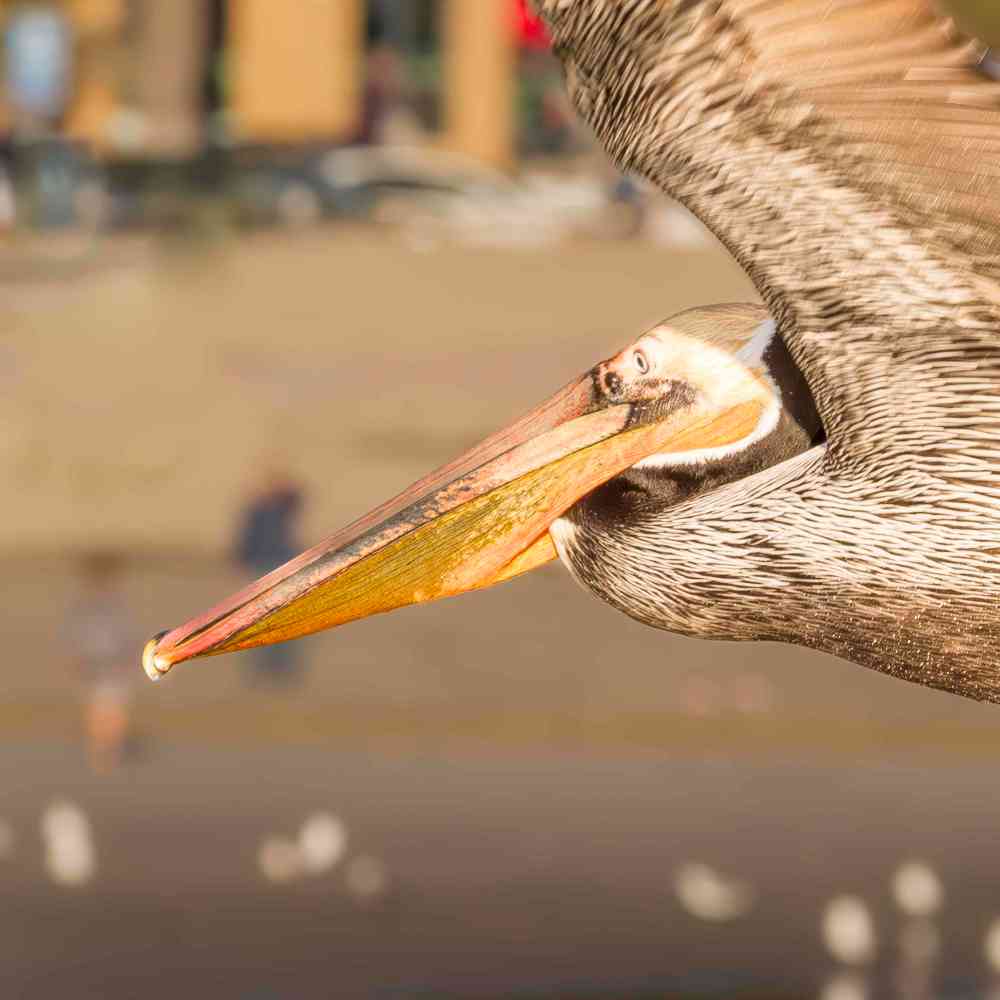
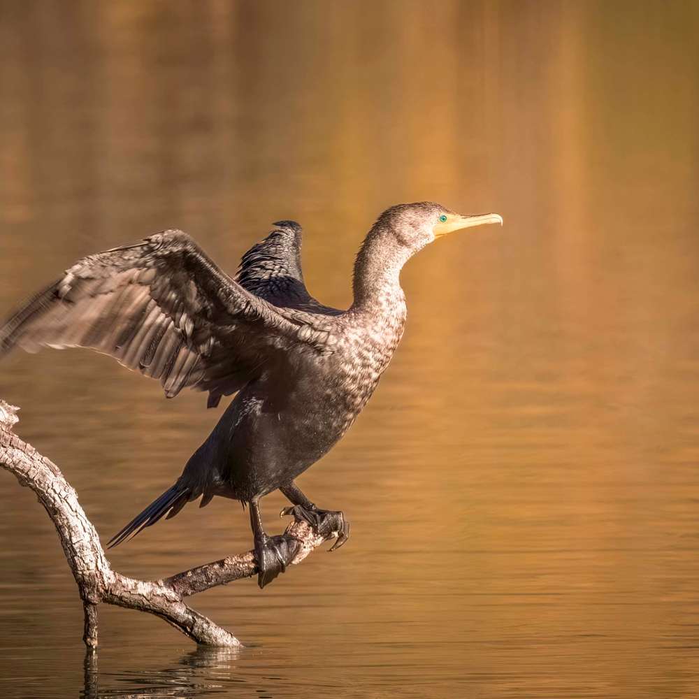
ペリカン目の中にはトキやサギなども含まれています。ちょっと以外でもありますが、水中の生き物を食するという共通項が同じグループになる理由なんでしょうかね。ともあれ、この目の鳥の写真はすでにたくさんあるので、満足です。 The order of Pelicans also includes Ibis and Herons. It is a little bit strange to me, but I guess the common denominator is that they all prey on underwater creatures. Anyway, I am satisfied with these birds because I already have many photos of them.
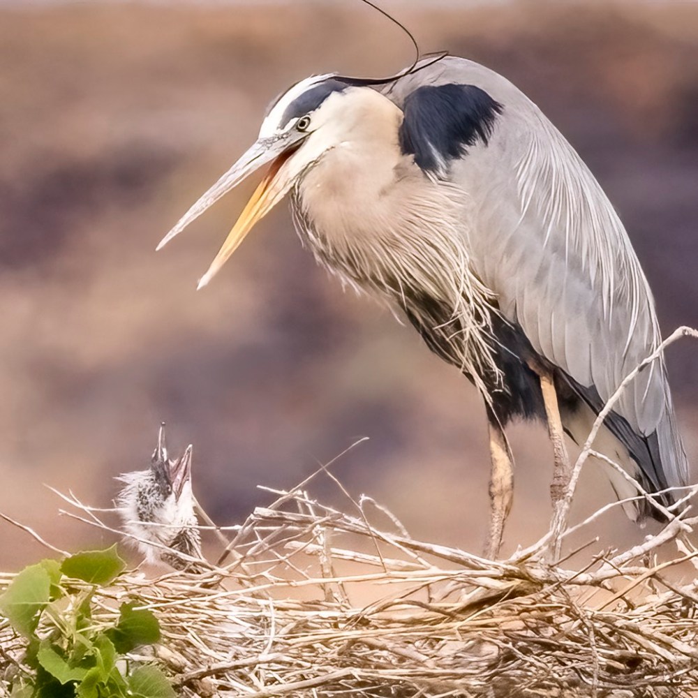
ユキコサギ Snowy Egretカッショクペリカン Brown Pelicanミミヒメウ Double-crested Cormorantカオジロブロンズトキ White-faced Ibisオオアオサギ Great blue Heron