Toe Trail は往復 5.8km 無理しないで歩ける、平らなトレイルです。 The Toe Trail is a flat and easy 3.6 mile trail.
毎日バスルームの窓から見えるレッドロックの麓を歩きます。 As you can see in the picture below, it’s very flat. Part of the trail runs right next to the bottom of the Red Rock which we see from our bathroom window everyday.
こちらが窓からの眺め。 This is the window view.
このレッドロックは二つの地層からできています。上層部がナバホ砂岩地層で、下層部がケヤンタ地層です。すごく分かりやすいですよね。 The Red Rock consists of two parts. The upper part is Navajo sandstone and the bottom is the Kayenta formation. Isn’t it easy to see the differences?
暖かくなってきたので、トカゲとかヘビとかに出会えるかなと期待しましたが、見られませんでした。でも、小鳥のさえずりが至る所から聞こえていました。それだけでも清々しかったです。 As it’s a little warmer these days, we hoped to see some lizards or snakes, but we didn’t see them. Instead, we heard little birds singing from the side of trail, and that made us feel so uplifted.
家の近くを走ってみました。 I ran around our neighborhood two days ago.
後で結果を見てみると、そんなに悪くないですね。でも、このペースを再現できるんでしょうか。トレッドミルなら自分でペースを調整することができますが、外を走る時はそれができない。 The result was pretty good. But I am not sure if I can reproduce the same pace again. When I run on a treadmill, I can control the pace but not when I run outside.
どうやったら、自分のペースを確立して、維持できるんでしょうか。 How can I establish my own pace and maintain it?
Shinob Kibe は ハリケン断層ラインに立つ小高い丘です。登って降りて来ると2.5 km ほどなので、1時間もあれば帰って来られますが、興味深い歴史物が残っているので2時間ぐらい時間をかけたい。Shinob Kibe is a small mesa standing along the line of Hurricane fault. The distance is only about 1.5 miles round trip, so it takes only one hour or so. However, I recommend to spend two hours because there are interesting historical objects.
草が生い茂ってしまい、よく分かりません。ハイキングリーダーの後に私まで写っていますが、そこを中心に4-6本の線が伸びて円を描いています。ここでどんな儀式が行われていたのでしょうか。I couldn’t recognize it until our hike leader pointed it out, because plants covered the rocks in places. In the picture above, our hike leader and myself are standing at the center of the wheel. From there, lines of rocks are laid out to make a large wheel. I am now curious what kind of ceremony was held there.
遺跡 2:航空用の矢印。頂上にはコンクリートでできた大きな矢印があります。1926年にロスアンジェルスからソルトレイクシティ間のエアメールサービスが開始されました。その時に パイロットが迷子にならないように10マイル(約16km)ごとに同じ矢印が設置されました。かつては航空塔があり、そこから無数のランプを灯して光を放っていたそうです。詳しい事は、このサイトをご覧ください。 Historic Ruin 2: An Aviation Navigation Arrow is on top of the mesa. The air mail service between Los Angeles and Salt Lake City started in 1926. An arrow like this was placed every 10 miles all the way to Salt Lake to help guide the pilots. An aviation tower holding a very bright rotating beacon stood in the center of the arrow to indicate the location of the arrow in bad weather. Look at this site for the detail.
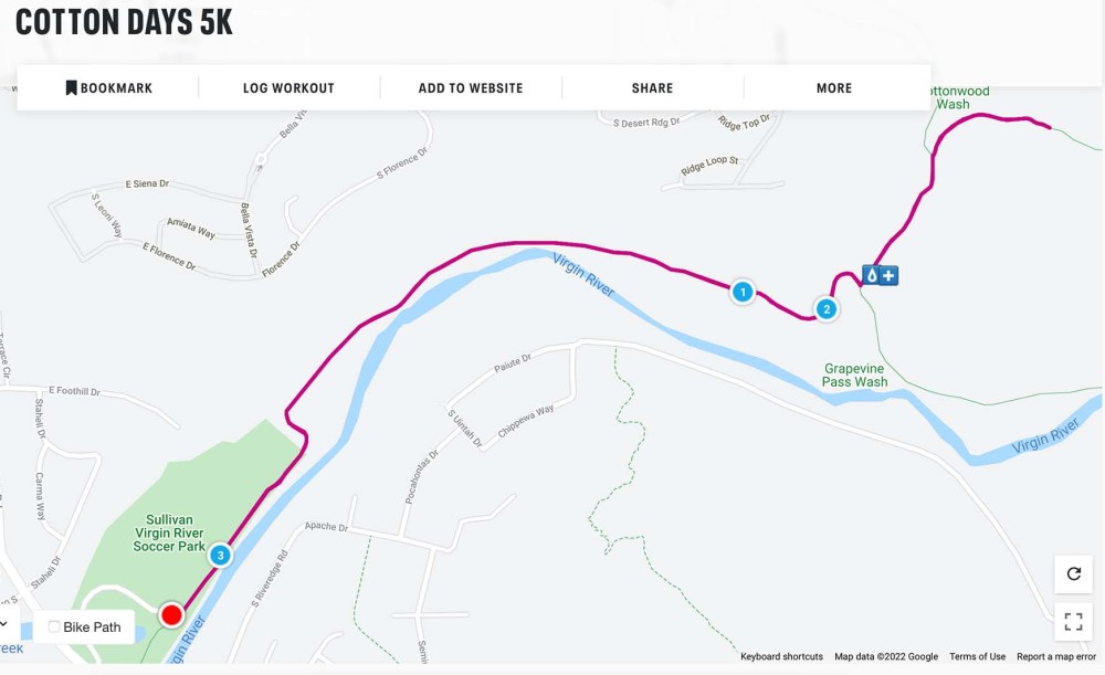
こうして歴史の勉強をして丘を下ってきたのですが、反対側の斜面の麓を見ると、なんか見覚えがあるような景色なんですね。 I was so happy learning two new historical facts before coming down the mesa. On the way to the bottom, I found something familiar at the bottom of the hill in front of me.
これはもしかして、私の5Kレースのコースかもしれない。Could it be my 5K race course?
家に帰って地図を見たら、やっぱりそうでした。バージン川を挟んで向こう側の遊歩道を走るんですね! I confirmed the course after coming back home. I will run the walking path on the other side of Virgin river!
膝の痛みを緩和するために、マッサージを始めました。とりわけ友人が教えてくれた膝に効くツボを重点的にしています。一週間継続して結果を見てみます。 I have started to massage my legs by myself to ease my knee pain. The focus is the pressure points for the knees which my friend taught me the other day. Let’s see how well it works, at least for a week or so.
その間、頑張らないで走ります。もう一度、最初からやり直してみよう。 In the meantime, I ran again, but with an easy pace. Let me start all over again.
8km の緩やかなハイキングコースでした。It was an easy 5 mile long trail.
ラバーキンク川の横には溶岩の崖がそびえ立っています。High cliffs of lava rocks are standing right next to the La Verkin Creek.
その崖の窪みには無数のツバメの巣がありました。We found many swallow’s nests on the wall cavities.
グループの年齢層は広くて、20歳代から70歳代まで。それでも一緒に歩いていると楽しい。みんな子供になっちゃうんでしょうか。ハイキングの魅力の一つです。The age range of our hiking group is very wide, from 20’s to 70’s. But we could enjoy being together while walking. I think that is one of nice things about going for a hike in a group.
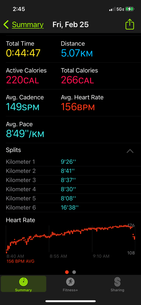
先週40分の壁を破ったその翌日、嬉しくてまた走ってしまいました。 The day after I broke the 40 minutes time wall last week, I was so happy. So I ran again the very next day.
それはいいんですが、膝の調子が … 痛い。That was all right for me, but my knee didn’t think so. It hurts now.
レースには出てみたいけど、無理はしたくないです。I want to attend the race, but I don’t want to overdo it.
歩いたりダンスをするだけなら気にならないので、医者に診てもらうほどじゃないと思います。そこで筋トレグッズを全部出してきて、モチベーションを高め、回復を待つ事にしました。もちろん、使いますよ。It doesn’t bother me when I walk or dance. So I think it’s not bad enough to see a doctor. So, I brought out all our stretching and muscle building tools. This will keep me motivated until I recover from the pain. Of course, I will use them.
5.96km、88m の登り。簡単な半日ハイキングコースでした。私たちは、横道に逸れて別ルートも歩いたので、距離は少し長めです。 It is a half day hiking trail, 3.7 miles and 289 feet elevation gain. We went off on a side trail at the end, so the distance is little longer than the trail itself.
かつて使われていた飛行場を左に見ながら歩くコースです。今はレストランや学校などができてきます。この10年間、この街がいかに変わって来たのかを話しながら歩きました。The old St. George airport was on the left side of the trail. It’s now used for variety of purposes. We talked about the town and how it has changed in the past 10 years while walking.
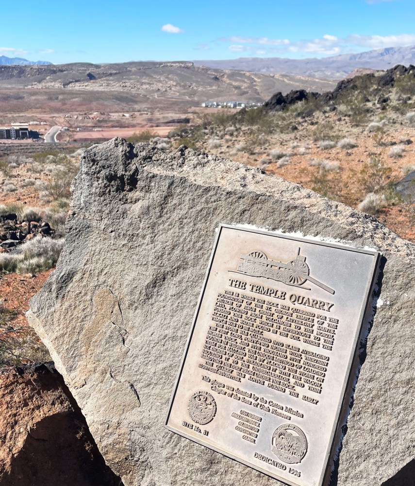
このトレイルは石碑ができるほど由緒ある道です。写真にあるように、1871年から3年間、溶岩を切り出すために使われました。The trail has an historical background, and a monument plate was attached to a rock. According to the description, it was used to carry lava rocks from 1871 to 1874.
セイントジョージの街の中心にあるセイントジョージ寺院はモルモン教の開拓者が建立しました。その際、地盤として溶岩を使う必要がありました。The Mormon pioneers needed lava rocks for the foundation of the Saint George Temple standing in the center of town.
溶岩が必要だった理由は、この地域の土壌はアルカリ成分を多く含んでいるので、その浸透を防ぐためだと、石碑には書かれてありました。 According to the monument description, they needed to use the lava rock because the soil at the temple site is an alkali soil, and lava rock was impervious to alkali soil.
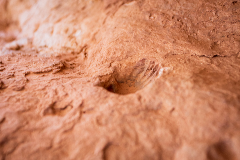
この道を切り開くためにダイナマイトが使われました。道脇には、ダイナマイトが差し込まれたであろう穴が残る石塊がまだ残っていました。The pioneers used dynamite charges to make the trail. We found rocks still containing holes for the dynamite charges on the side of the trail.
大きな機械がなかったころ、半端じゃない困難な作業だったに違いありません。Can you imagine how hard it was to carry such huge rocks down without any machinery?
でも、「不可能に立ち向かう」、それが人間の歴史でしたよね。だから宇宙にも行ける様になったんだ。思考が飛躍しました。でも、すごくない、私たち?人間万歳だ! But our history was always like that, wasn’t it? We kept challenging ourselves against impossibles, didn’t we? That’s why we could go to space. My thought leaped high from this, but, aren’t we great or what? Yes, Banzai human!
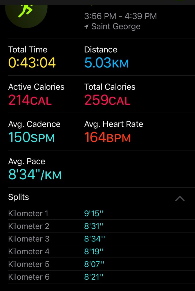
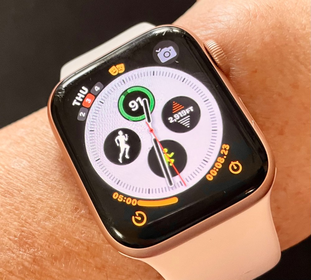
昨日、マラソン優勝歴が何回もある方と一緒に走る機会がありました。しかも屋外。彼女のアドバイスを聞き、美しい景色を眺めながら風を切るのは気持ちがいい。もう、春の風の匂いがする。その結果、なんと40分の壁を切った! I was lucky yesterday because I could run with a person who has numerous winning records in races. It was an outdoor run. While listening to her advice and gazing at beautiful scenery, I felt so good with the wind going through my hair. It was already a nice spring wind. And believe it or not, the result was shocking. I broke the 40 minute wall!!!
補足です。上のスクリーンショットは 4.84km になってるよ!?とご指摘されるかもしれませんね。はい、以下、説明です。You may be wondering why I say I broke 40 minutes for 5K since the screen shot above shows only 4.84 km. Good question. I will explain below.
こちらは違う日のトレッドミルの結果です。距離は5.32kmです。Here is a previous treadmill result for a different run showing 5.32 km.
こちらの記録は、同じランですが、アップルウォッチの記録です。距離はいつも 0.2 – 0.3 km 短めに記録されるのは、歩幅のキャリブレーションをしてないからだと思います。The data below is from my Apple watch on the same run. I know that Apple watch always records 0.2 – 0.3 km less than the treadmill because I haven’t done the calibration.
私の時計、キャリブレーションしなくちゃ。I better calibrate my Apple watch real soon.
再び、早朝のショートハイク。We went to another early morning short hike in fossil canyon. The distance was 5 km (3 miles.)
カンボジアの寺院、アンコールワット、を思い起こさせる岩が両側を囲みます。The rocks around there reminded me of temples in Cambodia, Angkor Wat.
ここはペルム紀から三畳紀の頃の地層であるらしい。そしてこのトレイルの名前通り、化石の山、Fossil Mountain という地層群なんですね。This area is the Fossil Mountain member of the Kaibab formation. The time period ranges from the Permian to the early Triassic.
だからこんな化石を発見することができました。We found tiny fossils like this.
貝殻かな、それとも植物の一部でしょうか。 Could it be a shell or a part of a plant?
距離はないのですが、谷間を進むので、結構難しい場所でした。The trail is not so long but it was challenging because we needed to go through a narrow canyon.
助け合いながら岩を登っていくハイクはとても楽しかったです。All in all, it was a fun hike with the hike members helping each other to go up and down rocks.
Cotton Day 5K というビギナー向けのレースにレジスターしました。4月30日、朝7時スタートです。I registered for a beginner race, Cotton Day 5K. It starts at 7:00 am on April 30.
当日は、あいにく、鳥の会のフェスティバルがあり、バンちゃんの応援はなく、たった一人で初参加となります。レースなんて一度も参加したことがないので、一体どうなることやらちょっと不安です。そうだ、ゼッケンは当日もらうのかな?だとしたら、かなり早く会場に行かないといけませんね。Unfortunately I need to be there alone without any support because there is a Bird Fest event on the exact same time and day. I have never attended any type of race, so I am worried about how the day will go. Come to think of it, I don’t know how I will get the race bib, where should I go to check in, etc. I better be there early.
何はともあれ、日時が決まり、私の中の迷いも無くなりました。あとは逆算でプランを立て、実行するのみです。In any case, the date is set, and my mind is set, too. All I need is to make a training plan.
レースの中間で高度が約73m (239 ft)、グッと上がるところがハイライトのようですね。このグラフを見る限り、大丈夫。走れます。急に硬度を増す所をトレーニングに取り入れてみます。I understand that the elevation will go up to a high point of 239 feet (73 m) around the mid point of the route. The starting altitude is about the same as our house. It’s all right. I can run. I will add the altitude change into my training.
気合いを入れるため、新しくHokaのランニングシューズを履いてみました。軽くてフカフカしてます。To motivate me more, I switched shoes to a new pair of Hoka running shoes. They are light and fluffy.
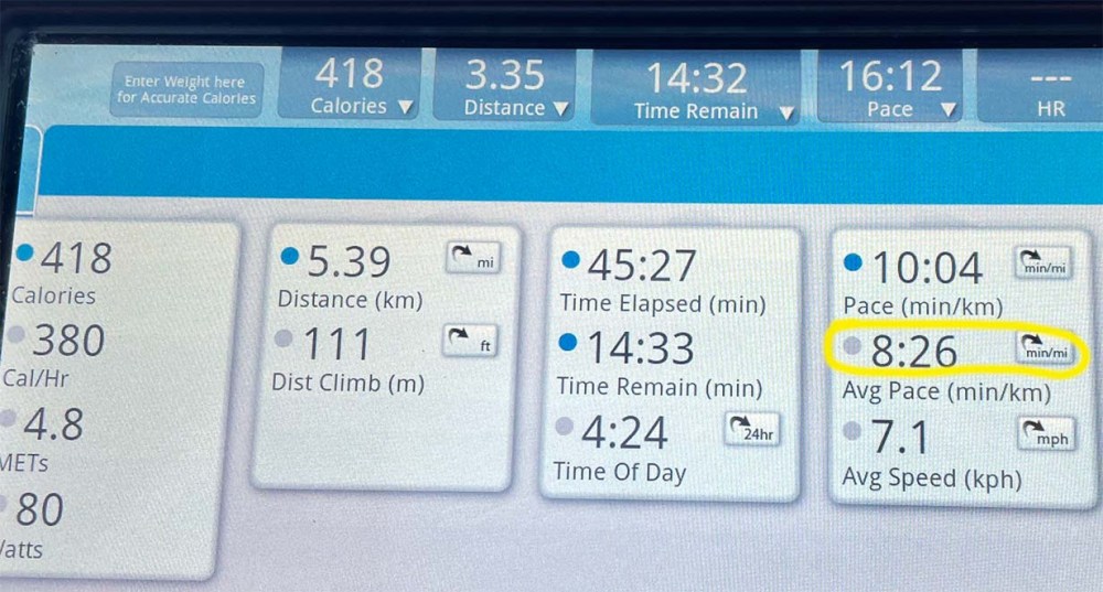
結果、ちょっと早くなった。 It made the result a little faster.
トレッドミルのペースもマイルからキロに変えたので、よくわかる。5倍すれば所要時間も簡単にわかってしまう。I changed the treadmill display from mile to km, so it’s so much easier to know the 5K time. I only need to multiply the pace 5 times.
約 4km 、1時間ちょいで終了した短い早朝ハイキングでした。手袋をしても指が凍りつきそうな寒さでした。 It was a short early morning hike that took only a little over one hour for 2.5 miles. It was so cold that my fingers could freeze even with gloves.
視界が開けると空に向かって口を開けているスコリア丘が見えました。At a viewpoint, we could see a black Cinder Cone opening its mouth towards the sky.
黒いスコリア丘が右に見えます。The black cinder cone is on the right side.
動物たちの足跡が凍りついた地面についていました。これはシカのヒズメでしょう。Because the ground was still frozen, we could see animal foot prints here and there. This must be deer’s hooves.