Tag Archives: Green River

ホースシューベンド Horseshoe Bend


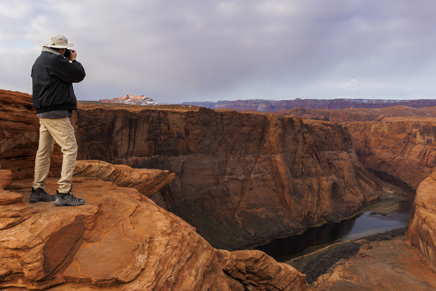
ペイジから少し南下した所に、コロラド川の馬蹄形をした場所が見下ろせる展望所があります。 The viewpoint of the Colorado river’s Horseshoe Bend was about 5 minutes south of Page.

24mmレンズで撮りました。16mmがあったらもっと余裕を持って撮れたことでしょう。 I used a 24mm lens. If I had 16mm, it would be a little easier to capture it.

流石に有名な観光スポットなので、寒い中でも10-20人ぐらいの観光客がきていました。全員がいなくなったと思ったら、なんと、T-レックスが写真家の指示に従って、ポーズをとっていました。 It’s a well known tourist spot. Even though it was a cold day, I saw 10-20 people walking on the path to the viewpoint. I wanted to take pictures after all the people left, so I waited a little. Then I found a T-Rex posing at the edge of a rock following a photographer’s request.

もちろん、着ぐるみを着ているだけですが、面白い発想です。 Of course, it was only a person wearing a T-Rex suit. But I thought the idea was interesting.

バンちゃんも色々な角度から撮っていました。 Banchan was also taking pictures from many different angles.

私は、高所は苦手なので、崖の淵に寝そべって撮りました。(写真はばんちゃん提供) I did, too, but lying down on the ground at the edge of the cliff because I am afraid of the height. (Below photo was taken by Banchan.)

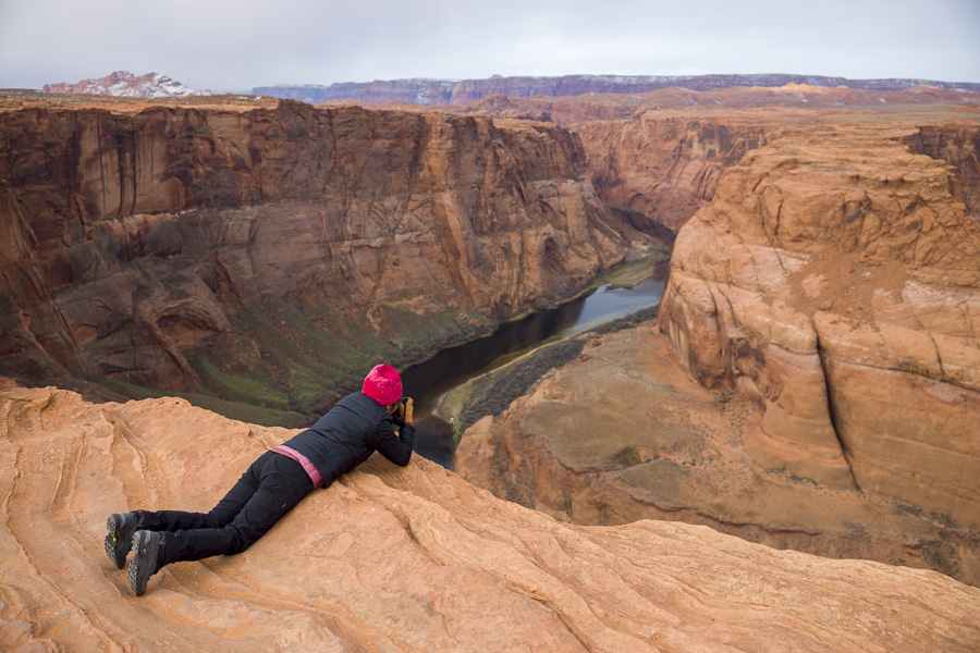
小雨が降る曇り日でしたが、朝日が雲間から顔を出し、岩壁の上部に光を刺してきました。川面に反射して、綺麗でした。 It was a cloudy day with light sprinkles, but the morning light came down through the tiny break of the clouds, and lit the top of the rocks. It reflected very well on the surface of the water.

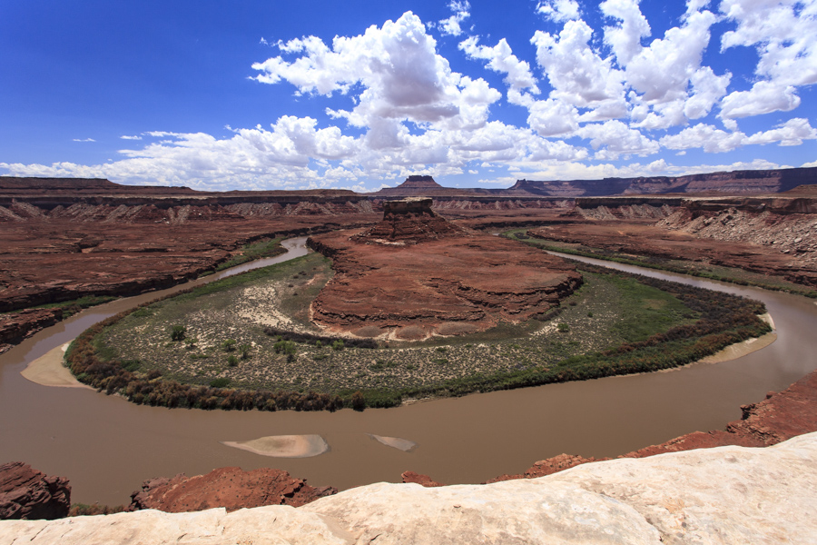
ところで、私たちは、10年前、キャニオンランド国立公園のホワイトリム巡りをしました。ここはコロラド川とグリーン川が南端で合流する場所です。7月の暑さが厳しい時、4日間かけてオフロードの道を走りました。グリーン川サイドにある馬蹄形のある場所に歩いていきましたが、そんな季節に訪れるの狂気の沙汰なので、当然、私たち以外、誰もいませんでした。 By the way, we visited White-rim road in Canyonlands national park 10 years ago. The south end was the place where the Colorado river and the Green river meet. We spent 4 days off-road to go around the White rim. It was mid July, the ridiculously hot season, but we walked to the edge of Green river’s horseshoe bend. We were the only people crazy enough to be there and didn’t see anyone else, needless to say.

こちらは16mmレンズでも収まりきらない程大きなものでした。 I used a 16mm lens for the picture below, but still couldn’t completely capture it.

化石の丘 – Fossil Butte


ワイオミング、コロラド、ユタ州をまたいで流れるグリーンリバー川は、力強く流れる水流で岩を削り、太古の様子を教えてくれる地層を露出してくれました。そして、露出された地層はグリーンリバー層と名付けられています。- The Green River runs through Wyoming, Colorado, and Utah, and exposed antient strata by sculpting surrounding rocks. The strata is named the Green River Formation.

グリーンリバー層が後ろに見えます。その上層部が Fossil Butte メンバー – The background is Green River formation, and the top portion is the Fossil Butte member.

中でも、私たちの訪れたFossil Butte (化石の丘)国定公園は Fossil Butte メンバーという特別な層です。ここでは特に魚の化石が採集され、その保存状態が良いことで有名です。 – Fossil Butte National Monument, which we visited, is known for many well preserved fish fossils.

レンジャーが化石採掘の丘をバックグラウンドに、魚の化石を見せながら歴史を説明してくれています。 – The park ranger explained the history of Fossil Butte with a fish fossils in his hand and the quarry on the background.

なぜ魚か?その答えを自分なりに理解するために時間がかかりました。なぜなら、私の理解の出来事と年代が重なっていたからです。- Why Fish? I wanted to digest the facts, and understand the reasons based on the facts. Therefore it took me longer than usual to write this post. I gathered the following facts.

  • 北アメリカ大陸プレートがほぼ現在の形になったのが約 4 – 2 千万年。- 40 – 20 million years ago, the North American plate took on its current shape.
  • 白亜紀海路(西武内陸海路)が存在したのは 6.6 – 2.3 千万年前。- 66 – 23 million years ago, Cretaceous seaway (Western Interior Seaway) existed.
  • 約 5.2 千万年前、 Fossil Butte のある一帯には巨大な湖が存在していた。そこは白亜紀海路の海路でもあった。- 52 million years ago, there is an ancient large lake existed around there. But, at the same time, Cretaceous seaway was running here as well.

これはどういうことでしょうか? – Does it make sense?

説明は簡単です。「全ては魔法のように一瞬に起こったわけではなく、徐々に変化していった。」- The answer is rather simple. “Nothing happens all at once like magic. Instead it changed gradually over a long span of time.”

北米プレートがほぼ現在の形になった頃、なんと日本海ができています。 – The Sea of Japan formed around the time of North American plate became about the current shape.

私流の理解:プレートの移動とロッキー山脈の隆起により、徐々に白亜紀海路の水が引いていき、そこに湖を作り出していった。始新世に存在した巨大な湖は、変遷過程にあったものである。アルカリ性濃度が高かったため、後に石灰岩となり、その薄い膜と他のシルト層が古生物を保存しつつ交互に堆積していった。その後、始新世の終わりには湖はなくなっていったが、グリーンリバーが岩を削り取り、その時代を蘇らせてくれた。- My understandings: The water of the Cretaceous Seaway gradually ebbed while the Rocky Mountains rose gradually, and it resulted in forming large lakes here and there. The large lakes during the Eocene were more alkaline, contains more minerals, allowing the formation of limestone layers. The limestone and silt layers contain ancient fish accumulated at the bottom of the lake. After the Eocene, the lake disappeared. Later, the Green River sculpted the rocks and revealed the bottom of the lake.

これで頭の中がようやくスッキリしました。- Phew. It’s much clearer now.

発掘された化石は、その後、研究室に送り込まれます。そこで顕微鏡を通して丁寧に時間をかけて化石の周りの石灰岩を取り除きます。この緻密な作業は、神経が磨り減りそうですが、結構面白そうです。化石に触らず、エアブラシを吹き付けて取り除きますが、勿論、空気噴射だけでは取り除けないので、ある物質の微粒が含まれています。その物質が、化石の周りの石灰岩を削り取ってくれるわけですね。そして、その注目の物質とは、化石より強度が弱く、しかも石灰岩より強度が強い物質、苦灰岩、別名ドロマイトです!6月17日のブログに書いた、例の鉱物です。デスバレー国立公園近くにある、ドロマイト採掘場のあの白い光景が浮かんできます。- Fossils from the quarry go to the lab. Specialists then remove limestone from the fossil carefully through a microscope. It’s hard work that requires full attention to detail, but quite interesting. By spraying a jet of air, limestone is ablated a little at a time. The jet of air alone doesn’t do so much. So micro beads of a substance is included in the jet of air. The bead material has to be harder than limestone yet less hard than the fossil. The substance that fits the qualification is Dolomite. I wrote about the Dolomite quarry on June 17th blog.

そんな風にして蘇った化石は、古生物学者に多くのことを語りかけてくれています。- After such a long process, many fossils have been revealed which tell the ancient stories to paleontologists.

ところで、バンちゃんはここで魚の化石を買ってきました。彼の化石コレクションに加わりました。この魚は彼に何を語りかけてくれるのでしょうか。- By the way, Banchan bought a fish fossil from here. It’s added to his fossil collection. I wonder what kind of stories this fossil fish is telling him now.

Priscacara serrata という魚の化石 – Fish fossil “Priscacara serrata“.

ミサゴとの出会い – Meeting Osprey


ワイオミング州の南端とユタ州の最北端に位置るすフレイミングゴージ貯水池は、グリーンリバー川に作られています。私たちの旅のハイライトのは、そこでボートをチャーターして探索する予定でした。が、なんとどこもかしこも予約済みで、2-3日後まで空きがないとのこと。ウェブサイトには先着順と書いてあったのに!みんな泣きそう。- Flaming Gorge Reservoir is in the southwest corner of Wyoming and the northernmost part of Utah along the Green River. One of our planned highlights was to rent a boat and to cruise around the reservoir for the day. But it was fully booked, not only for the day, but for next 2-3 days! The website said it’s first-come first-served!!! I almost cried.

それでも諦めきれず、1%のチャンスの想いを込めて釣り専用のボート屋さんに留守電を残しました。思いを込めればなんとかなるものです。なんと夕暮れ時の3時間に予約を入れることができました。- But we didn’t give up. We took a slim chance and left a message at a fishing boat service. Believe it or not, it worked. We arranged for a three-hour boat ride in the late afternoon towards sunset.

フレイミングゴージ(燃える渓谷)の名前の由来は、朝日を受けて燃える湖畔の岩の色です。さぞかし綺麗なことでしょう。でも、夕暮れ時だって負けてない。なぜなら、ミサゴに出会えたからです。- The gorge was named “Flaming Gorge” because the cliff faces on the sides of the reservoir glow as red as flame when they are lit by the morning sunlight. I am sure it’s a gorgeous sight. But still, I think the sunset tour was also as great because we could meet Osprey.

ミサゴは魚が主食です。だから魚が獲れる水辺に住んでいます。そして、魚をしっかりと獲るために足の指が独特に発達し、第1趾はぐるりと反転させ流ことができるそうです。私の親指は90度ぐらいしか動かないんですが、それが180度動くんですね。- Osprey eat fish only. Therefore, they live near water where they can catch fish. To catch fish well, they evolved their outer toe to be reversible. Think about our thumbs, which moves only about 90 degrees for humans, but Osprey’s outer toe moves 180 degrees. Wow!

こちらは貯水池に架かるカートクリーク橋。- This is Cart Creek bridge over Flaming Gorge Reservoir.

その上をよく見ると、いた!ミサゴの子供達が巣の上でお母さんの帰りを待っています。ミサゴの巣は結構大きいので、見つけやすいようです。- If you look at the top of the bridge carefully, you can find a nest. Yes, two baby Osprey are in the nest waiting for their mother’s return. It’s said that their nest is quite large compared to other birds, so it’s easier to find them.

この貯水池では大きなマスが釣れるので、魚釣りとしても有名なようです。どうか2匹ともここで獲れた美味しいマスをたくさん食べて元気に巣立っていって欲しいです。- The reservoir is famous for Trout fishing as well. I hope those chicks eat as much Trout as they can and fledge soon so they can fly into the sky.